


<< Our Photo Pages >> Benthall Round Cairn - Cairn in England in Northumberland
Submitted by Anne T on Tuesday, 22 May 2018 Page Views: 1814
Neolithic and Bronze AgeSite Name: Benthall Round Cairn Alternative Name: Benthall CistsCountry: England County: Northumberland Type: Cairn
Nearest Town: Seahouses Nearest Village: Beadnell
Map Ref: NU2371528908
Latitude: 55.553296N Longitude: 1.625648W
Condition:
| 5 | Perfect |
| 4 | Almost Perfect |
| 3 | Reasonable but with some damage |
| 2 | Ruined but still recognisable as an ancient site |
| 1 | Pretty much destroyed, possibly visible as crop marks |
| 0 | No data. |
| -1 | Completely destroyed |
| 5 | Superb |
| 4 | Good |
| 3 | Ordinary |
| 2 | Not Good |
| 1 | Awful |
| 0 | No data. |
| 5 | Can be driven to, probably with disabled access |
| 4 | Short walk on a footpath |
| 3 | Requiring a bit more of a walk |
| 2 | A long walk |
| 1 | In the middle of nowhere, a nightmare to find |
| 0 | No data. |
| 5 | co-ordinates taken by GPS or official recorded co-ordinates |
| 4 | co-ordinates scaled from a detailed map |
| 3 | co-ordinates scaled from a bad map |
| 2 | co-ordinates of the nearest village |
| 1 | co-ordinates of the nearest town |
| 0 | no data |
Internal Links:
External Links:
")
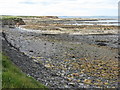
This Bronze Age round cairn is recorded as both Pastscape Monument No. 8211 and Historic England List ID 1008430. It is sited on the edge of a cliff, to the north of Beadnell harbour (and lime kilns), just inside a private garden and next to the footpath along the shoreline.
Visible remains comprise a cist which sits on the edge of an amorphous mound of boulders. The mound is roughly circular, measuring 15m in diameter, standing to a height of approx. 0.4m. Today, several self-seeded bushes grow out of the middle of the cist. A second cist, now no longer visible, used to lie 3.5m to the south of the first.
Both cists were discovered and partially excavated in 1934. The Historic England entry tells us: "the first ... is built of large sandstone slabs orientated WNW by ESE and measures 0.9m by 0.6m and is 0.5m deep. It contained the bones of a prehistoric burial. The second cist measured 0.8m by 0.6m and was 0.6m deep. The removal of a covering slab of sandstone revealed the remains of a second prehistoric burial along with a decorated Bronze Age pottery vessel; the pot is now in the Museum of Antiquities in Newcastle."
You may be viewing yesterday's version of this page. To see the most up to date information please register for a free account.
")
")
Do not use the above information on other web sites or publications without permission of the contributor.
Nearby Images from Geograph Britain and Ireland:

©2015(licence)

©2022(licence)

©2017(licence)

©2017(licence)
©2017(licence)
The above images may not be of the site on this page, they are loaded from Geograph.
Please Submit an Image of this site or go out and take one for us!
Click here to see more info for this site
Nearby sites
Key: Red: member's photo, Blue: 3rd party photo, Yellow: other image, Green: no photo - please go there and take one, Grey: site destroyed
Download sites to:
KML (Google Earth)
GPX (GPS waypoints)
CSV (Garmin/Navman)
CSV (Excel)
To unlock full downloads you need to sign up as a Contributory Member. Otherwise downloads are limited to 50 sites.
Turn off the page maps and other distractions
Nearby sites listing. In the following links * = Image available
319m SE 129° St Ebba's Chapel* Ancient Cross (NU2396428707)
1.2km NW 325° Beadnell Caravan Park Rock Art (NU2300029900)
2.5km SW 236° Long Nanny* Standing Stone (Menhir) (NU21632748)
3.4km SW 226° Tughall Chapel* Ancient Cross (NU2132026540)
3.8km NW 326° North Sunderland Cists* Cist (NU21603202)
3.8km NW 315° North Sunderland (Seahouses) Rock Art (NU2100031600)
7.1km WSW 242° St Maurice's Well (Ellingham)* Holy Well or Sacred Spring (NU17452553)
7.3km SSE 164° Dunstanburgh Castle* Promontory Fort / Cliff Castle (NU2571821930)
7.3km NNW 345° St. Cuthbert's Well (Farne Islands)* Holy Well or Sacred Spring (NU21783599)
7.5km WSW 246° Ellingham a & d Rock Art (NU1691025790)
7.5km WSW 246° Ellingham b & c Rock Art (NU1686025750)
7.6km NW 319° Bamburgh Barrow 2* Round Barrow(s) (NU18633464)
7.7km NW 317° Bamburgh Barrow 1* Round Barrow(s) (NU1841634486)
7.7km W 277° Bradford Kaims Ancient Mine, Quarry or other Industry (NU16022980)
8.1km NW 316° Leper's Well (Bamburgh)* Holy Well or Sacred Spring (NU18053475)
8.1km NW 319° Bamburgh Castle* Sculptured Stone (NU1837335053)
8.3km NW 317° St Aidan's Well (Bamburgh)* Holy Well or Sacred Spring (NU1803234914)
8.4km NW 316° St Aidan's Church (Bamburgh)* Early Christian Sculptured Stone (NU1784334964)
8.5km W 280° St Hilda's Church (Lucker)* Ancient Cross (NU15303033)
9.8km WNW 301° Spindlestone Hill Fort* Hillfort (NU152339)
10.4km W 263° Isabella's Mount Camp Hillfort (NU13372757)
10.6km WSW 249° Wandylaw G Rock Art (NU1380125116)
10.6km WSW 249° Wandylaw B Rock Art (NU1379525109)
10.6km WSW 249° Wandylaw D Rock Art (NU1379325112)
10.6km WSW 249° Wandylaw E* Rock Art (NU1379425109)
View more nearby sites and additional images


 We would like to know more about this location. Please feel free to add a brief description and any relevant information in your own language.
 Wir möchten mehr über diese Stätte erfahren. Bitte zögern Sie nicht, eine kurze Beschreibung und relevante Informationen in Deutsch hinzuzufügen.
 Nous aimerions en savoir encore un peu sur les lieux. S'il vous plaît n'hesitez pas à ajouter une courte description et tous les renseignements pertinents dans votre propre langue.
 Quisieramos informarnos un poco más de las lugares. No dude en añadir una breve descripción y otros datos relevantes en su propio idioma.