<< Our Photo Pages >> Sewingshields Crags - Stone Row / Alignment in England in Northumberland
Submitted by Andy B on Tuesday, 24 March 2015 Page Views: 2599
Neolithic and Bronze AgeSite Name: Sewingshields CragsCountry: England
NOTE: This site is 1.295 km away from the location you searched for.
County: Northumberland Type: Stone Row / Alignment
Map Ref: NY8042570857
Latitude: 55.031847N Longitude: 2.307778W
Condition:
| 5 | Perfect |
| 4 | Almost Perfect |
| 3 | Reasonable but with some damage |
| 2 | Ruined but still recognisable as an ancient site |
| 1 | Pretty much destroyed, possibly visible as crop marks |
| 0 | No data. |
| -1 | Completely destroyed |
| 5 | Superb |
| 4 | Good |
| 3 | Ordinary |
| 2 | Not Good |
| 1 | Awful |
| 0 | No data. |
| 5 | Can be driven to, probably with disabled access |
| 4 | Short walk on a footpath |
| 3 | Requiring a bit more of a walk |
| 2 | A long walk |
| 1 | In the middle of nowhere, a nightmare to find |
| 0 | No data. |
| 5 | co-ordinates taken by GPS or official recorded co-ordinates |
| 4 | co-ordinates scaled from a detailed map |
| 3 | co-ordinates scaled from a bad map |
| 2 | co-ordinates of the nearest village |
| 1 | co-ordinates of the nearest town |
| 0 | no data |
Internal Links:
External Links:
I have visited· I would like to visit
Anne T visited on 8th May 2015 - their rating: Cond: 3 Amb: 4 Access: 3 Sewingshields Crags Possible Stone Row, now known to be a boundary feature: I'm putting this on for completeness, as Andy B has added this as a site in it's own right; for my originalvisit report with more details, see Simonburn (Davy's Lee) Stone Circle visit report, 20th July 2014.
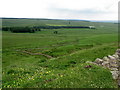
Having spotted a group of features on the map that looked interesting: Davy's Lee Settlement, Davy's Lee Stone Circle and various tumuli, we decided to take advantage of the sunshine and walk to this area. The previous weekend, we'd visited Standingstone Rigg, near Great Lonbrough Farm. If we had continued south along the footpath for a couple of kilometres from Standingstone Rigg, we would have reached Davy’s Lee from the north. Instead, we took the opposite approach, from the south, from the old military road (B6318). My husband parked the car by the Old Repeater Station (parking on the Old Military Road being sparse and difficult, with soft verges, lay-by's virtually non-existent and fast-flying cars driving up and down) having dropped me off at the farmhouse 100 yards west from this road junction, on the opposite side of the road, by the footpath up to Sewingshields and Sewingshields Crags. We’ve done this walk before, to see the Roman fishing loughs, but with this walk, we needed to follow the path nortwards past the farmhouses, round the back of Sewingshields Crags to the bottom of the hill, then turn off a track to the left hand side (approx. Grid reference: NY 80653 70820). The track disappears for a while, so we headed left up a bank with what looked like quarried stone at the top, running in a double row running approximately east to west (approx. Grid ref: NY 80393 70793).
Note: at the time of writing, I am going along to this area next week to help survey a group of stack-stands and/or sheilings (12th to 15th) so will have another look at this feature then.
")
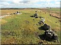
The possible stone row contains 28 visible stones and extends 34 metres from NY8044770864 to NY80425 70857.
Source: Landscape Survey North of Sewingshields Crags, 18th - 22nd March 2014 Initial Summary by the Tynedale Archaeology group
[March 2015 Update: Phil Bowyer writes: When our group did a subsequent Level 3 survey with a professional archaeologist the interpretation of the feature was revised to a boundary feature (possibly prehistoric but certainly old) rather than a stone row.]
Some other findings in the report: Immediately south of the ridge Tynedale Archaeology group recorded two north-south alignments of large stones running up to the ridge. One of the stone alignments continued north of the ridge.
"Just south of the summit of Queen’s Crags, in the vicinity of HER12409 Enclosed Romano-British
Settlement we discovered low stony linear features that may be the remains of associated field boundaries on both east-west and north-south alignments."
"Adjacent to the external round house recorded under HER12409 we discovered an earth fast cup-marked boulder decorated with a crescent of 5 single cups. This stone lies some 60 metres east of a large cup-marked boulder which we discovered in 2012. No rock art has previously been recorded in the vicinity of Queen’s Crags."
You may be viewing yesterday's version of this page. To see the most up to date information please register for a free account.
")
")
Do not use the above information on other web sites or publications without permission of the contributor.
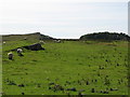
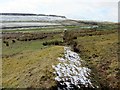
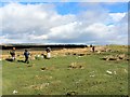
Nearby Images from Geograph Britain and Ireland:
©2014(licence)
©2007(licence)
©2014(licence)
©2014(licence)
©2007(licence)
The above images may not be of the site on this page, they are loaded from Geograph.
Please Submit an Image of this site or go out and take one for us!
Click here to see more info for this site
Nearby sites
Key: Red: member's photo, Blue: 3rd party photo, Yellow: other image, Green: no photo - please go there and take one, Grey: site destroyed
Download sites to:
KML (Google Earth)
GPX (GPS waypoints)
CSV (Garmin/Navman)
CSV (Excel)
To unlock full downloads you need to sign up as a Contributory Member. Otherwise downloads are limited to 50 sites.
Turn off the page maps and other distractions
Nearby sites listing. In the following links * = Image available
400m NNW 328° Simonburn* Stone Circle (NY8021571198)
455m NW 319° Kings Crags Burial Mounds Not Known (by us) (NY8013071204)
483m WNW 303° King Wanless Green (cist) 1* Rock Art (NY8002071123)
496m NNE 13° Davy's Lee Enclosure* Misc. Earthwork (NY80547134)
525m NNE 28° Davy's Lee 1* Rock Art (NY8067171321)
605m WNW 288° Kings Crags Cairn* Cairn (NY79857105)
717m WNW 292° King's Crag 1 Rock Art (NY7976071130)
815m W 266° King's Crags Cairns* Round Cairn (NY79617080)
836m WSW 238° Queen's Crags Cup Marked Boulders* Rock Art (NY79717042)
1.4km NW 310° Crow Crags Cairnfield* Cairn (NY79397174)
1.4km NNW 327° Crow Crags Round Cairn* Round Cairn (NY79687200)
1.5km NNW 341° Crow Crags Settlement* Ancient Village or Settlement (NY79967224)
2.5km SW 215° Housesteads Roman Fort* Stone Fort or Dun (NY78986880)
2.5km WSW 250° Greenlee Lough B* Rock Art (NY7806069988)
2.7km NNE 27° Standingstone Rigg* Stone Row / Alignment (NY8169073272)
2.7km SSW 202° Housesteads Tumulus* Artificial Mound (NY7938268330)
2.7km SE 126° West Howden Hill* Ancient Village or Settlement (NY82666925)
2.9km WSW 248° Ridley Common* Stone Circle (NY77756977)
2.9km SW 221° Hadrian's Wall - Milecastle 37* Stone Fort or Dun (NY78506869)
2.9km SSW 201° Housesteads Mound* Misc. Earthwork (NY79386815)
2.9km ESE 113° Howden Hill Cist* Cist (NY8310469692)
2.9km ESE 113° Howden Hill 2* Rock Art (NY8313769688)
2.9km ESE 113° Howden Hill 1* Rock Art (NY8313769687)
2.9km WSW 249° Ridley Common Enclosure* Ancient Village or Settlement (NY77676979)
3.0km ESE 111° Howden Hill Western Cairn* Cairn (NY8322469751)
View more nearby sites and additional images


 We would like to know more about this location. Please feel free to add a brief description and any relevant information in your own language.
 Wir möchten mehr über diese Stätte erfahren. Bitte zögern Sie nicht, eine kurze Beschreibung und relevante Informationen in Deutsch hinzuzufügen.
 Nous aimerions en savoir encore un peu sur les lieux. S'il vous plaît n'hesitez pas à ajouter une courte description et tous les renseignements pertinents dans votre propre langue.
 Quisieramos informarnos un poco más de las lugares. No dude en añadir una breve descripción y otros datos relevantes en su propio idioma.