


<< Text Pages >> Bradley Hall Ice House Barrow - Round Barrow(s) in England in Tyne and Wear
Submitted by durhamnature on Friday, 26 October 2012 Page Views: 3388
Neolithic and Bronze AgeSite Name: Bradley Hall Ice House BarrowCountry: England
NOTE: This site is 1.395 km away from the location you searched for.
County: Tyne and Wear Type: Round Barrow(s)
Nearest Town: Gateshead Nearest Village: Crawcrook
Map Ref: NZ12236333
Latitude: 54.964451N Longitude: 1.810518W
Condition:
| 5 | Perfect |
| 4 | Almost Perfect |
| 3 | Reasonable but with some damage |
| 2 | Ruined but still recognisable as an ancient site |
| 1 | Pretty much destroyed, possibly visible as crop marks |
| 0 | No data. |
| -1 | Completely destroyed |
| 5 | Superb |
| 4 | Good |
| 3 | Ordinary |
| 2 | Not Good |
| 1 | Awful |
| 0 | No data. |
| 5 | Can be driven to, probably with disabled access |
| 4 | Short walk on a footpath |
| 3 | Requiring a bit more of a walk |
| 2 | A long walk |
| 1 | In the middle of nowhere, a nightmare to find |
| 0 | No data. |
| 5 | co-ordinates taken by GPS or official recorded co-ordinates |
| 4 | co-ordinates scaled from a detailed map |
| 3 | co-ordinates scaled from a bad map |
| 2 | co-ordinates of the nearest village |
| 1 | co-ordinates of the nearest town |
| 0 | no data |
Internal Links:
External Links:
A bronze age round barrow was opened at Bradley Hall sometime before 1787 and reported in that year. It was found to contain "a square cavity, composed of stones set on edge, which enclosed the remains and ashes of the interred". Later reports describe a skeleton found within the cist.
The burial site has been modified to make an ice house in the late 18th century.
There is no public access to this site.
Tyne and Wear HER Number 514
You may be viewing yesterday's version of this page. To see the most up to date information please register for a free account.
Do not use the above information on other web sites or publications without permission of the contributor.
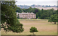
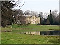
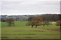
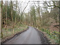
Nearby Images from Geograph Britain and Ireland:
©2013(licence)
©2016(licence)

©2016(licence)
©2010(licence)
©2016(licence)
The above images may not be of the site on this page, they are loaded from Geograph.
Please Submit an Image of this site or go out and take one for us!
Click here to see more info for this site
Nearby sites
Key: Red: member's photo, Blue: 3rd party photo, Yellow: other image, Green: no photo - please go there and take one, Grey: site destroyed
Download sites to:
KML (Google Earth)
GPX (GPS waypoints)
CSV (Garmin/Navman)
CSV (Excel)
To unlock full downloads you need to sign up as a Contributory Member. Otherwise downloads are limited to 50 sites.
Turn off the page maps and other distractions
Nearby sites listing. In the following links * = Image available
339m ESE 118° Bradley Hall Dene Barrow Round Barrow(s) (NZ12536317)
1.4km SE 144° White Well, Greenside* Holy Well or Sacred Spring (NZ13036222)
1.5km NNE 32° Simmery Hill Cist, Clara Vale* Cist (NZ13026462)
2.1km SSW 203° North View enclosure* Ancient Village or Settlement (NZ114614)
2.3km E 86° Ryton 2 Rock Art (NZ1450063500)
2.4km NE 55° Ryton 3 Rock Art (NZ1420064700)
2.5km E 86° The Ryton Stone Rock Art (NZ1475063500)
2.7km ENE 72° Ryton 1 Rock Art (NZ1480064170)
3.0km W 272° Prudhoe Castle* Rock Art (NZ09186342)
3.1km ESE 121° Holy Well, Greenside* Holy Well or Sacred Spring (NZ14936170)
3.2km N 0° Houghton Camp, Heddon on the Hill* Ancient Village or Settlement (NZ12246657)
3.3km ENE 63° Ryton Motte or Tumulus* Artificial Mound (NZ15176483)
3.7km W 276° Ovingham Cross* Ancient Cross (NZ08506370)
3.7km NNE 18° St Andrew's Church (Heddon on the Wall)* Ancient Cross (NZ1338666892)
3.8km NW 312° Croft's Well (Horsley)* Holy Well or Sacred Spring (NZ0939965821)
3.9km NNE 21° Hadrian's Wall (Heddon on the Wall)* Misc. Earthwork (NZ13616693)
4.2km NW 315° Horsley Hill Homestead* Ancient Village or Settlement (NZ09266624)
4.2km NE 38° Throckley Bank Portable Rock Art (NZ1482066670)
4.2km NE 38° Throckley Bank Top Rock Art (NZ1482866677)
4.4km S 174° Ceoppa's Barrow* Round Barrow(s) (NZ1270258908)
4.6km E 84° Stella enclosure Ancient Village or Settlement (NZ168638)
4.8km WNW 286° Eddybroth Well (Whittle Dene)* Holy Well or Sacred Spring (NZ0760464659)
5.3km W 276° St Andrew's Well (Ovington)* Holy Well or Sacred Spring (NZ0697563896)
5.3km WNW 287° Hunters Hill (Ovington) Rock Art (NZ0711064900)
5.4km E 89° Summerhill Cists* Cist (NZ176634)
View more nearby sites and additional images


 We would like to know more about this location. Please feel free to add a brief description and any relevant information in your own language.
 Wir möchten mehr über diese Stätte erfahren. Bitte zögern Sie nicht, eine kurze Beschreibung und relevante Informationen in Deutsch hinzuzufügen.
 Nous aimerions en savoir encore un peu sur les lieux. S'il vous plaît n'hesitez pas à ajouter une courte description et tous les renseignements pertinents dans votre propre langue.
 Quisieramos informarnos un poco más de las lugares. No dude en añadir una breve descripción y otros datos relevantes en su propio idioma.