


<< Our Photo Pages >> Long Scar Pike - Cairn in England in Cumbria
Submitted by BlueZMonkey on Thursday, 22 August 2019 Page Views: 1179
Neolithic and Bronze AgeSite Name: Long Scar PikeCountry: England County: Cumbria Type: Cairn
Nearest Village: Crosby Ravensworth
Map Ref: NY5933810862
Latitude: 54.491453N Longitude: 2.629238W
Condition:
| 5 | Perfect |
| 4 | Almost Perfect |
| 3 | Reasonable but with some damage |
| 2 | Ruined but still recognisable as an ancient site |
| 1 | Pretty much destroyed, possibly visible as crop marks |
| 0 | No data. |
| -1 | Completely destroyed |
| 5 | Superb |
| 4 | Good |
| 3 | Ordinary |
| 2 | Not Good |
| 1 | Awful |
| 0 | No data. |
| 5 | Can be driven to, probably with disabled access |
| 4 | Short walk on a footpath |
| 3 | Requiring a bit more of a walk |
| 2 | A long walk |
| 1 | In the middle of nowhere, a nightmare to find |
| 0 | No data. |
| 5 | co-ordinates taken by GPS or official recorded co-ordinates |
| 4 | co-ordinates scaled from a detailed map |
| 3 | co-ordinates scaled from a bad map |
| 2 | co-ordinates of the nearest village |
| 1 | co-ordinates of the nearest town |
| 0 | no data |
Internal Links:
External Links:
")
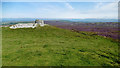
Much of the surface of the monument is composed of small pieces of limestone but beneath this layer are larger blocks of the same material. There is an irregularly shaped hollow in the centre of the mound.
The surface of the cairn has been disturbed by the construction of a early 20thC cairn in the middle of the monument.
You may be viewing yesterday's version of this page. To see the most up to date information please register for a free account.
Do not use the above information on other web sites or publications without permission of the contributor.
Nearby Images from Geograph Britain and Ireland:

©2016(licence)

©2008(licence)
©2020(licence)
©2020(licence)

©2017(licence)
The above images may not be of the site on this page, they are loaded from Geograph.
Please Submit an Image of this site or go out and take one for us!
Click here to see more info for this site
Nearby sites
Key: Red: member's photo, Blue: 3rd party photo, Yellow: other image, Green: no photo - please go there and take one, Grey: site destroyed
Download sites to:
KML (Google Earth)
GPX (GPS waypoints)
CSV (Garmin/Navman)
CSV (Excel)
To unlock full downloads you need to sign up as a Contributory Member. Otherwise downloads are limited to 50 sites.
Turn off the page maps and other distractions
Nearby sites listing. In the following links * = Image available
1.1km SSW 211° The Galloway Stone* Natural Stone / Erratic / Other Natural Feature (NY58780994)
1.4km NE 50° Wicker Street* Cairn (NY60411173)
1.6km ENE 61° White Hag* Stone Circle (NY60721160)
1.8km E 88° Hazel Moor Enclosure* Ancient Village or Settlement (NY611109)
1.8km ENE 66° White Hag Round cairn* Round Cairn (NY61011158)
1.9km E 91° Kings Well spring* Holy Well or Sacred Spring (NY612108)
1.9km N 6° Seal Howe* Cairn (NY59541272)
1.9km N 8° Seal Howe Iron Age/Romano British field system* Misc. Earthwork (NY5961612783)
2.0km N 10° Seal Howe Cairn 2* Round Cairn (NY5969912781)
2.1km N 356° Oddendale* Stone Circle (NY59201291)
2.1km SW 232° Shap Wells Iron Age/Romano British Settlement Ancient Village or Settlement (NY5767309593)
2.1km NNW 330° St Anne's Well (Shap)* Holy Well or Sacred Spring (NY5829412700)
2.3km NNE 23° Seal Howe Cairn 3* Round Cairn (NY6025312925)
2.3km N 356° Oddendale stone alignment* Stone Row / Alignment (NY5919113205)
2.5km N 359° Kalmott cairn circle* Ring Cairn (NY59301333)
2.5km ENE 62° Cow Green Long Barrow* Long Barrow (NY61541199)
2.6km NE 42° Ewe Locks* Ancient Village or Settlement (NY6112512794)
2.9km N 353° Hardendale Timber Circle (NY590137)
3.1km NNE 32° Ewe Close* Ancient Village or Settlement (NY61021348)
3.2km E 96° Howe Robin Ancient Village or Settlement (NY625105)
3.2km ENE 63° Burwens Ancient Village or Settlement (NY622123)
3.5km NW 313° Kemp Howe* Stone Circle (NY56801330)
3.6km E 96° Penhurrock* Multiple Stone Rows / Avenue (NY62881043)
3.9km W 277° Thorny Bank* Cairn (NY555114)
3.9km N 4° Iron Hill South* Stone Circle (NY59641476)
View more nearby sites and additional images


 We would like to know more about this location. Please feel free to add a brief description and any relevant information in your own language.
 Wir möchten mehr über diese Stätte erfahren. Bitte zögern Sie nicht, eine kurze Beschreibung und relevante Informationen in Deutsch hinzuzufügen.
 Nous aimerions en savoir encore un peu sur les lieux. S'il vous plaît n'hesitez pas à ajouter une courte description et tous les renseignements pertinents dans votre propre langue.
 Quisieramos informarnos un poco más de las lugares. No dude en añadir una breve descripción y otros datos relevantes en su propio idioma.