


<< Our Photo Pages >> Gray Bull - Natural Stone / Erratic / Other Natural Feature in England in Cumbria
Submitted by MonumentMan on Thursday, 05 December 2019 Page Views: 1294
Natural PlacesSite Name: Gray BullCountry: England
NOTE: This site is 0.518 km away from the location you searched for.
County: Cumbria Type: Natural Stone / Erratic / Other Natural Feature
Nearest Town: Kendal Nearest Village: Shap
Map Ref: NY5396209201
Latitude: 54.476066N Longitude: 2.711965W
Condition:
| 5 | Perfect |
| 4 | Almost Perfect |
| 3 | Reasonable but with some damage |
| 2 | Ruined but still recognisable as an ancient site |
| 1 | Pretty much destroyed, possibly visible as crop marks |
| 0 | No data. |
| -1 | Completely destroyed |
| 5 | Superb |
| 4 | Good |
| 3 | Ordinary |
| 2 | Not Good |
| 1 | Awful |
| 0 | No data. |
| 5 | Can be driven to, probably with disabled access |
| 4 | Short walk on a footpath |
| 3 | Requiring a bit more of a walk |
| 2 | A long walk |
| 1 | In the middle of nowhere, a nightmare to find |
| 0 | No data. |
| 5 | co-ordinates taken by GPS or official recorded co-ordinates |
| 4 | co-ordinates scaled from a detailed map |
| 3 | co-ordinates scaled from a bad map |
| 2 | co-ordinates of the nearest village |
| 1 | co-ordinates of the nearest town |
| 0 | no data |
Be the first person to rate this site - see the 'Contribute!' box in the right hand menu.
Internal Links:
External Links:
")
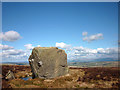
On approach it is visible from 3/4 kilometre away as a large angular block on the horizon, almost being mistaken for a small house.
Gray Bull is a glacial erratic of Shap Pink Granite, weathered, fractured and covered in turf and lichens, attesting to its considerable age. The name of the erratic may originate from the fact it looks strikingly similar to a large bull in profile, complete with head and eyes. It is massive at >2.5m high and >3.5m long and 3m wide.
It sits alongside a smaller boulder and a shallow pond.
On inspection of the surface features - it appeared there might be an intentional Stone Art 'cup' mark located left and beneath the eye socket, possibly carved also. The cup was circular and smooth compared to the rest of the erratic.
You may be viewing yesterday's version of this page. To see the most up to date information please register for a free account.
")
")
")
")
Do not use the above information on other web sites or publications without permission of the contributor.
Nearby Images from Geograph Britain and Ireland:
©2012(licence)

©2006(licence)

©2008(licence)

©2006(licence)

©2006(licence)
The above images may not be of the site on this page, they are loaded from Geograph.
Please Submit an Image of this site or go out and take one for us!
Click here to see more info for this site
Nearby sites
Key: Red: member's photo, Blue: 3rd party photo, Yellow: other image, Green: no photo - please go there and take one, Grey: site destroyed
Download sites to:
KML (Google Earth)
GPX (GPS waypoints)
CSV (Garmin/Navman)
CSV (Excel)
To unlock full downloads you need to sign up as a Contributory Member. Otherwise downloads are limited to 50 sites.
Turn off the page maps and other distractions
Nearby sites listing. In the following links * = Image available
863m ESE 106° To Stone or to'ther* Natural Stone / Erratic / Other Natural Feature (NY5479208955)
2.7km NE 34° Thorny Bank* Cairn (NY555114)
3.4km SE 134° Clovenstone Hill* Natural Stone / Erratic / Other Natural Feature (NY5637706859)
3.7km E 83° Shap Wells Iron Age/Romano British Settlement Ancient Village or Settlement (NY5767309593)
4.3km N 353° White Raise Round Cairn A* Round Cairn (NY5347313431)
4.3km N 352° White Raise Round Cairn B* Round Cairn (NY5342913450)
4.6km N 354° Blaze Hill Round Cairn* Round Cairn (NY5355613795)
4.9km E 81° The Galloway Stone* Natural Stone / Erratic / Other Natural Feature (NY58780994)
5.0km NE 34° Kemp Howe* Stone Circle (NY56801330)
5.3km NNE 30° Shap Avenue* Multiple Stone Rows / Avenue (NY567138)
5.6km NE 50° St Anne's Well (Shap)* Holy Well or Sacred Spring (NY5829412700)
5.6km ENE 72° Long Scar Pike* Cairn (NY5933810862)
5.7km N 5° Stone Howe Cairn (NY545149)
6.0km NNE 22° The Giant's Foot (Cumbria)* Standing Stone (Menhir) (NY5630014781)
6.2km NNE 18° Goggleby Stone* Standing Stone (Menhir) (NY5592215093)
6.3km NNE 14° Keld Lane Stones* Standing Stone (Menhir) (NY5554615286)
6.3km NNE 17° Aspers Field* Standing Stone (Menhir) (NY5584115208)
6.4km NE 54° Oddendale* Stone Circle (NY59201291)
6.5km NNE 14° Skellaw Hill Tumulus* Round Barrow(s) (NY5565015470)
6.6km NE 52° Oddendale stone alignment* Stone Row / Alignment (NY5919113205)
6.6km ENE 57° Seal Howe* Cairn (NY59541272)
6.7km N 10° Thunder Stone (Shap)* Natural Stone / Erratic / Other Natural Feature (NY55151575)
6.7km ENE 57° Seal Howe Iron Age/Romano British field system* Misc. Earthwork (NY5961612783)
6.7km NE 52° Kalmott cairn circle* Ring Cairn (NY59301333)
6.7km NE 48° Hardendale Timber Circle (NY590137)
View more nearby sites and additional images


 We would like to know more about this location. Please feel free to add a brief description and any relevant information in your own language.
 Wir möchten mehr über diese Stätte erfahren. Bitte zögern Sie nicht, eine kurze Beschreibung und relevante Informationen in Deutsch hinzuzufügen.
 Nous aimerions en savoir encore un peu sur les lieux. S'il vous plaît n'hesitez pas à ajouter une courte description et tous les renseignements pertinents dans votre propre langue.
 Quisieramos informarnos un poco más de las lugares. No dude en añadir una breve descripción y otros datos relevantes en su propio idioma.