


<< Our Photo Pages >> Hutton Roof Crag perched Limestone Boulder - Natural Stone / Erratic / Other Natural Feature in England in Cumbria
Submitted by MonumentMan on Monday, 25 November 2019 Page Views: 2471
Natural PlacesSite Name: Hutton Roof Crag perched Limestone BoulderCountry: England County: Cumbria Type: Natural Stone / Erratic / Other Natural Feature
Nearest Town: Kirkby Lonsdale Nearest Village: Hutton Roof
Map Ref: SD5686878268
Latitude: 54.198341N Longitude: 2.662636W
Condition:
| 5 | Perfect |
| 4 | Almost Perfect |
| 3 | Reasonable but with some damage |
| 2 | Ruined but still recognisable as an ancient site |
| 1 | Pretty much destroyed, possibly visible as crop marks |
| 0 | No data. |
| -1 | Completely destroyed |
| 5 | Superb |
| 4 | Good |
| 3 | Ordinary |
| 2 | Not Good |
| 1 | Awful |
| 0 | No data. |
| 5 | Can be driven to, probably with disabled access |
| 4 | Short walk on a footpath |
| 3 | Requiring a bit more of a walk |
| 2 | A long walk |
| 1 | In the middle of nowhere, a nightmare to find |
| 0 | No data. |
| 5 | co-ordinates taken by GPS or official recorded co-ordinates |
| 4 | co-ordinates scaled from a detailed map |
| 3 | co-ordinates scaled from a bad map |
| 2 | co-ordinates of the nearest village |
| 1 | co-ordinates of the nearest town |
| 0 | no data |
Internal Links:
External Links:
I have visited· I would like to visit
lboutside visited - their rating: Amb: 5
")
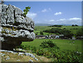
A.W. Wainwright in his 'Westmorland Heritage' documents it and says it is likely to be the largest in the county of its type.
The sheer size and precarious nature of this boulders perched position means the utmost care must be exercised when approaching the boulder.
DO NOT APPROACH IT FROM DOWNSLOPE or you may not survive if it rolled over you! Surely not many more years are left in the plinth beneath it and it is already leaning downslope.
You may be viewing yesterday's version of this page. To see the most up to date information please register for a free account.
")
")
")
Do not use the above information on other web sites or publications without permission of the contributor.
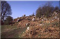
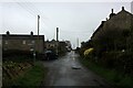
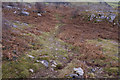
Nearby Images from Geograph Britain and Ireland:
©2016(licence)
©2022(licence)
©2010(licence)
©2008(licence)

©2011(licence)
The above images may not be of the site on this page, they are loaded from Geograph.
Please Submit an Image of this site or go out and take one for us!
Click here to see more info for this site
Nearby sites
Key: Red: member's photo, Blue: 3rd party photo, Yellow: other image, Green: no photo - please go there and take one, Grey: site destroyed
Download sites to:
KML (Google Earth)
GPX (GPS waypoints)
CSV (Garmin/Navman)
CSV (Excel)
To unlock full downloads you need to sign up as a Contributory Member. Otherwise downloads are limited to 50 sites.
Turn off the page maps and other distractions
Nearby sites listing. In the following links * = Image available
1.5km ENE 64° Gallowber Lane Romano-British Settlement/Enclosure* Ancient Village or Settlement (SD5823678908)
3.0km NW 304° Holme Park Fell 2* Rock Outcrop (SD5439879957)
3.3km NW 305° Holme Park Fell 1* Rock Outcrop (SD5419280141)
3.8km ESE 104° Sellet Bank Enclosure* Ancient Village or Settlement (SD60517733)
4.0km WSW 250° St James's Church (Burton-in-Kendal) Ancient Cross (SD5305076921)
6.3km SE 133° St John the Baptist (Tunstall)* Early Christian Sculptured Stone (SD6141473925)
6.3km WSW 241° Yealand ancient stone walls or rows 2 Misc. Earthwork (SD513753)
6.6km SW 236° Yealand ancient stone walls or rows 1 Misc. Earthwork (SD514746)
6.7km ENE 56° Howerigg* Ancient Village or Settlement (SD62488192)
7.0km SW 219° Manor Farm* Round Barrow(s) (SD52387285)
7.1km W 277° The Rent Stone* Natural Stone / Erratic / Other Natural Feature (SD498792)
7.2km ENE 76° Casterton* Stone Circle (SD63937999)
7.6km WNW 283° Bela Stone Row* Stone Row / Alignment (SD495801)
7.7km SSE 157° St Wilfrid (Melling)* Ancient Cross (SD5978571115)
7.8km WSW 239° Summerhouse Hill Cairn* Cairn (SD50147428)
7.9km WSW 240° Summerhouse Hill* Modern Stone Circle etc (SD50037437)
8.1km W 275° The Fairy Steps* Natural Stone / Erratic / Other Natural Feature (SD488790)
8.2km E 100° Leck Hall* Ancient Village or Settlement (SD64927677)
8.2km ENE 74° Brownthwaite Pike Round Cairn* Round Cairn (SD6477280479)
8.4km S 177° St John the Evangelist (Gressingham)* Ancient Cross (SD5725069915)
8.6km WNW 286° Haverbrack Fell Misc. Earthwork (SD486807)
8.7km SW 233° Warton Crag giant wall Misc. Earthwork (SD499731)
8.7km S 171° Castle Stede Hillfort (SD582697)
8.8km WSW 236° The Three brothers* Natural Stone / Erratic / Other Natural Feature (SD495735)
8.8km WNW 281° The Dog Hole Cave or Rock Shelter (SD482801)
View more nearby sites and additional images


 We would like to know more about this location. Please feel free to add a brief description and any relevant information in your own language.
 Wir möchten mehr über diese Stätte erfahren. Bitte zögern Sie nicht, eine kurze Beschreibung und relevante Informationen in Deutsch hinzuzufügen.
 Nous aimerions en savoir encore un peu sur les lieux. S'il vous plaît n'hesitez pas à ajouter une courte description et tous les renseignements pertinents dans votre propre langue.
 Quisieramos informarnos un poco más de las lugares. No dude en añadir una breve descripción y otros datos relevantes en su propio idioma.