<< Our Photo Pages >> Borecka Forest Alignment - Stone Row / Alignment in Poland in Warminsko-mazurskie
Submitted by AlexHunger on Monday, 15 December 2008 Page Views: 5188
Neolithic and Bronze AgeSite Name: Borecka Forest AlignmentCountry: Poland
NOTE: This site is 12.915 km away from the location you searched for.
Voivodeship: Warminsko-mazurskie Type: Stone Row / Alignment
Nearest Town: Lipowo Nearest Village: Borecka
Latitude: 54.089670N Longitude: 22.156480E
Condition:
| 5 | Perfect |
| 4 | Almost Perfect |
| 3 | Reasonable but with some damage |
| 2 | Ruined but still recognisable as an ancient site |
| 1 | Pretty much destroyed, possibly visible as crop marks |
| 0 | No data. |
| -1 | Completely destroyed |
| 5 | Superb |
| 4 | Good |
| 3 | Ordinary |
| 2 | Not Good |
| 1 | Awful |
| 0 | No data. |
| 5 | Can be driven to, probably with disabled access |
| 4 | Short walk on a footpath |
| 3 | Requiring a bit more of a walk |
| 2 | A long walk |
| 1 | In the middle of nowhere, a nightmare to find |
| 0 | No data. |
| 5 | co-ordinates taken by GPS or official recorded co-ordinates |
| 4 | co-ordinates scaled from a detailed map |
| 3 | co-ordinates scaled from a bad map |
| 2 | co-ordinates of the nearest village |
| 1 | co-ordinates of the nearest town |
| 0 | no data |
Internal Links:
External Links:
")
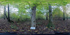
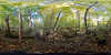
Alignment in Poland with possible Cup Hole.
You may be viewing yesterday's version of this page. To see the most up to date information please register for a free account.
")
Do not use the above information on other web sites or publications without permission of the contributor.
Nearby Images from Flickr

The above images may not be of the site on this page, but were taken nearby. They are loaded from Flickr so please click on them for image credits.
Click here to see more info for this site
Nearby sites
Click here to view sites on an interactive map of the areaKey: Red: member's photo, Blue: 3rd party photo, Yellow: other image, Green: no photo - please go there and take one, Grey: site destroyed
Download sites to:
KML (Google Earth)
GPX (GPS waypoints)
CSV (Garmin/Navman)
CSV (Excel)
To unlock full downloads you need to sign up as a Contributory Member. Otherwise downloads are limited to 50 sites.
Turn off the page maps and other distractions
Nearby sites listing. In the following links * = Image available
667m NW 319° Borki Cup-Marked Stone* Rock Art
2.1km NNW 330° Borki Stone Cirlce (2)* Stone Circle
2.5km NW 322° Borki Stone Circle (1)* Stone Circle
10.0km ESE 102° Kurhan Dybowo Round Barrow(s)
30.3km ENE 58° Grodzisko Gulberek* Hillfort
39.4km S 171° Grodzisko Bajtkowo Hillfort
47.8km WNW 300° Grodzisko Bajory Wielkie Hillfort
50.1km ENE 71° Grodzisko Szurpiły* Hillfort
50.9km E 80° Kurhany Prudziszki (1) Barrow Cemetery
52.2km E 79° Kurhany Prudziszki (2) Barrow Cemetery
53.2km ENE 75° Kurhan Wołownia Round Barrow(s)
54.0km E 83° Grodzisko Osinki Hillfort
55.3km NE 40° Vištyčio akmuo* Natural Stone / Erratic / Other Natural Feature
60.0km W 273° Kurhan Tołkiny Round Barrow(s)
79.4km E 92° Grodzisko Posejnele Hillfort
80.8km NE 41° Vilkaviškio krašto akmuo* Marker Stone
81.7km W 270° Bisztynek - Diabelski Kamień Natural Stone / Erratic / Other Natural Feature
87.9km NNE 31° Lithuanian Millenium Stone* Modern Stone Circle etc
92.8km W 280° Grodzisko Ardapy Promontory Fort / Cliff Castle
95.7km ENE 60° Padovinio piliakalnis* Artificial Mound
96.2km WNW 287° Grodzisko Bezledy Hillfort
99.7km ENE 63° Varnupių akmuo* Natural Stone / Erratic / Other Natural Feature
99.9km ENE 63° Varnupių piliakalnis* Artificial Mound
101.2km ENE 68° Bambininkų piliakalnis* Artificial Mound
103.1km W 269° Grodzisko Jarandowo Hillfort
View more nearby sites and additional images


 We would like to know more about this location. Please feel free to add a brief description and any relevant information in your own language.
 Wir möchten mehr über diese Stätte erfahren. Bitte zögern Sie nicht, eine kurze Beschreibung und relevante Informationen in Deutsch hinzuzufügen.
 Nous aimerions en savoir encore un peu sur les lieux. S'il vous plaît n'hesitez pas à ajouter une courte description et tous les renseignements pertinents dans votre propre langue.
 Quisieramos informarnos un poco más de las lugares. No dude en añadir una breve descripción y otros datos relevantes en su propio idioma.