


<< Other Photo Pages >> Norththorpe Henge - Henge in England in Yorkshire (East)
Submitted by Bladup on Friday, 05 December 2025 Page Views: 2102
Neolithic and Bronze AgeSite Name: Norththorpe HengeCountry: England
NOTE: This site is 2.293 km away from the location you searched for.
County: Yorkshire (East) Type: Henge
Nearest Town: Kingston upon Hull Nearest Village: Hornsea
Map Ref: TA19804890
Latitude: 53.922389N Longitude: 0.177213W
Condition:
| 5 | Perfect |
| 4 | Almost Perfect |
| 3 | Reasonable but with some damage |
| 2 | Ruined but still recognisable as an ancient site |
| 1 | Pretty much destroyed, possibly visible as crop marks |
| 0 | No data. |
| -1 | Completely destroyed |
| 5 | Superb |
| 4 | Good |
| 3 | Ordinary |
| 2 | Not Good |
| 1 | Awful |
| 0 | No data. |
| 5 | Can be driven to, probably with disabled access |
| 4 | Short walk on a footpath |
| 3 | Requiring a bit more of a walk |
| 2 | A long walk |
| 1 | In the middle of nowhere, a nightmare to find |
| 0 | No data. |
| 5 | co-ordinates taken by GPS or official recorded co-ordinates |
| 4 | co-ordinates scaled from a detailed map |
| 3 | co-ordinates scaled from a bad map |
| 2 | co-ordinates of the nearest village |
| 1 | co-ordinates of the nearest town |
| 0 | no data |
Internal Links:
External Links:
")
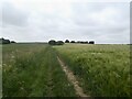
The principal feature of the East Field crop mark site is interpreted as a henge because the cropmarks are consistent with other known henges in terms of features, scale and particularly its setting within the landscape. Its position, on slightly elevated ground, yet not on the highest land within the immediate area, is very typical for a henge. In the Neolithic, the lower lying ground to the north, south and east of the henge is likely to have been open water, before subsequent silting and drainage in more recent centuries for agricultural improvement. The association with open water is also a typical association for henges.
The henge is thought to have been reused in the Bronze Age as a ringwork because of the way that the surrounding field system clearly respects and directly relates to it. The form of this field system is not Neolithic in character, but is consistent with being part of a more extensive Bronze Age co-axial field system. In form and scale, the cropmark interpreted as a henge is also consistent with those interpreted as Bronze Age ringworks, however its position in the landscape, being low lying, is not typical. This strongly indicates that the site was not a purpose built ringwork, but was opportunistically adapted from a pre-existing monument in the landscape.
The main element is a roughly circular cropmark of a substantial ditch around 6-8m wide enclosing an area about 50m in diameter. There is a marked break in this ditch to the ESE of the centre, forming an entrance to the enclosure. The terminals of the ditch either side of the entrance are emphasised, the ditch widening to form inward pointing horns, with the entrance passage being about 10m wide, narrowing slightly internally. Immediately outside of the main ditch, clearly respecting the entrance, there is a parallel, narrower cropmark interpreted as a beam slot designed to support the inner face of the henge's encircling bank. A further, intermittent cropmark is interpreted as either an outlying, encircling ditch or the beam slot which retained the outer face of the bank. If it is the latter, the bank would have been about 15m wide. Within the interior of the henge there is a roughly circular crop mark around 15m in diameter, also with an entrance to the SSE. This is interpreted as a high-status domestic round house related to the reuse of the henge as a Bronze Age ringwork, however it may be the remains of a Neolithic structure: an inner ritual enclosure or building forming part of the henge or potentially an earlier phase of the ritual site, predating the construction of the henge's bank and ditch.
Further cropmarks within East Field indicate that there is a co-axial field system which extends beyond the scheduled area. This field system is defined by crop marks of boundary ditches which extend WNW to ESE and NNE to SSW. The henge lies to the centre of one field which is approximately square, being around 120m across. The northern boundary appears to curve around to accommodate the outer ditch or beam-slot of the henge, whilst in the eastern boundary there appears to be a break in the ditch directly in line with the henge's single entrance. On either side of the northern boundary of the field to the east, there are cropmarks of a series of smaller rectangular ditched enclosures ranging between 10m to 40m across, probably representing paddocks, garden or other enclosures related to the reuse of the henge as a Bronze Age ringwork.
You may be viewing yesterday's version of this page. To see the most up to date information please register for a free account.
")
Do not use the above information on other web sites or publications without permission of the contributor.
Nearby Images from Geograph Britain and Ireland:
©2021(licence)

©2017(licence)
©2017(licence)

©2025(licence)

©2024(licence)
The above images may not be of the site on this page, they are loaded from Geograph.
Please Submit an Image of this site or go out and take one for us!
Click here to see more info for this site
Nearby sites
Key: Red: member's photo, Blue: 3rd party photo, Yellow: other image, Green: no photo - please go there and take one, Grey: site destroyed
Download sites to:
KML (Google Earth)
GPX (GPS waypoints)
CSV (Garmin/Navman)
CSV (Excel)
To unlock full downloads you need to sign up as a Contributory Member. Otherwise downloads are limited to 50 sites.
Turn off the page maps and other distractions
Nearby sites listing. In the following links * = Image available
7.2km NNW 331° Skipsea mound* Artificial Mound (TA1609455094)
10.7km NNW 339° All Saints (Barmston)* Sculptured Stone (TA156588)
11.7km WNW 294° St Elgin's Church* Ancient Cross (TA090534)
16.4km NW 323° St John's Well (Harpham)* Holy Well or Sacred Spring (TA095617)
17.6km NW 318° Fox Hill Tumulus* Round Barrow(s) (TA07606167)
18.5km NW 306° Southburn Archaeological Museum* Museum (TA0453959360)
18.5km WNW 303° Nafferton Slack (Driffield) Standing Stone (Menhir) (TA040587)
18.6km NW 313° Ruston Beacon (Ruston Parva) Cairn (TA05846128)
18.7km WSW 240° Beverley Minster Early Christian Sculptured Stone (TA03773925)
19.5km NNW 331° Rudston A Cursus* Cursus (TA099657)
19.6km NNW 331° Rudston Cult Centre* Ancient Village or Settlement (TA099658)
19.6km NNW 330° Rudston Beacon Round Barrow* Round Barrow(s) (TA0945365617)
19.8km W 272° Cleves Top (High Bradley) Rock Art (SE99934916)
19.8km NNW 334° Southside Mount* Round Barrow(s)
20.0km WNW 292° Kelleythorpe Barrow* Round Barrow(s) (TA0106755981)
20.2km NNW 340° Caythorpe Misc. Earthwork (TA125678)
20.9km N 6° Gell Spring* Holy Well or Sacred Spring (TA213698)
21.1km NW 316° Gallows Hill Barrow Round Barrow(s) (TA04776379)
21.2km NNW 338° Greenland Fort Hillfort (TA115684)
21.3km NNW 332° Rudston B Cursus Cursus (TA094675)
21.3km NNW 332° Rudston Cursus Group Cursus (TA092674)
21.3km NNW 334° Rudston Monolith* Standing Stone (Menhir) (TA0980367743)
21.4km NNW 335° Rudston C Cursus Cursus (TA102680)
21.4km NNW 333° Rudston D Cursus Cursus (TA097678)
21.4km NNW 329° Rudston B Cursus Cursus (TA081669)
View more nearby sites and additional images


 We would like to know more about this location. Please feel free to add a brief description and any relevant information in your own language.
 Wir möchten mehr über diese Stätte erfahren. Bitte zögern Sie nicht, eine kurze Beschreibung und relevante Informationen in Deutsch hinzuzufügen.
 Nous aimerions en savoir encore un peu sur les lieux. S'il vous plaît n'hesitez pas à ajouter une courte description et tous les renseignements pertinents dans votre propre langue.
 Quisieramos informarnos un poco más de las lugares. No dude en añadir una breve descripción y otros datos relevantes en su propio idioma.