


<< Text Pages >> Easington Beach - Henge in England in Yorkshire (East)
Submitted by Andy B on Tuesday, 26 June 2007 Page Views: 11630
Neolithic and Bronze AgeSite Name: Easington BeachCountry: England
NOTE: This site is 3.698 km away from the location you searched for.
County: Yorkshire (East) Type: Henge
Nearest Village: Easington
Map Ref: TA408187
Latitude: 53.645864N Longitude: 0.128564E
Condition:
| 5 | Perfect |
| 4 | Almost Perfect |
| 3 | Reasonable but with some damage |
| 2 | Ruined but still recognisable as an ancient site |
| 1 | Pretty much destroyed, possibly visible as crop marks |
| 0 | No data. |
| -1 | Completely destroyed |
| 5 | Superb |
| 4 | Good |
| 3 | Ordinary |
| 2 | Not Good |
| 1 | Awful |
| 0 | No data. |
| 5 | Can be driven to, probably with disabled access |
| 4 | Short walk on a footpath |
| 3 | Requiring a bit more of a walk |
| 2 | A long walk |
| 1 | In the middle of nowhere, a nightmare to find |
| 0 | No data. |
| 5 | co-ordinates taken by GPS or official recorded co-ordinates |
| 4 | co-ordinates scaled from a detailed map |
| 3 | co-ordinates scaled from a bad map |
| 2 | co-ordinates of the nearest village |
| 1 | co-ordinates of the nearest town |
| 0 | no data |
Internal Links:
External Links:
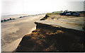
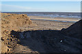
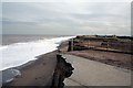
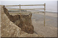
Possible hengi-form enclosure at Easington Beach, Holderness, East Yorkshire. The circular site identified as a possible henge monument lies within the parish of Easington, on the Holderness peninsula leading to Spurn Point. This area, which is susceptible to coastal erosion, is well known for its prehistoric sites of late Neolithic and Bronze Age date.
Previous archaeological work in the area includes the excavation of a Bronze Age barrow, with evidence of Neolithic occupation beneath the barrow. Other barrows have been identified from aerial photographs. Additionally large scale fieldwalking has been carried out in the area as part of the Humber Wetlands Survey (Head et al. 1995). Remains of a Bronze Age plank boat has also been recorded from the beach (Van de Noort et al. in press). More recently, a barrow was identified and excavated on the beach to the north of the henge, from which a centrally positioned inhumation burial, a hearth and late Bronze Age pottery was recorded.
More details in the report at English Heritage.
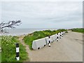
IMPORTANT NOTE: Grid Reference given is for Easington Beach Car Park
You may be viewing yesterday's version of this page. To see the most up to date information please register for a free account.
Do not use the above information on other web sites or publications without permission of the contributor.
Nearby Images from Geograph Britain and Ireland:
©2006(licence)
©2014(licence)
©2015(licence)
©2009(licence)
©2009(licence)
The above images may not be of the site on this page, they are loaded from Geograph.
Please Submit an Image of this site or go out and take one for us!
Click here to see more info for this site
Nearby sites
Key: Red: member's photo, Blue: 3rd party photo, Yellow: other image, Green: no photo - please go there and take one, Grey: site destroyed
Download sites to:
KML (Google Earth)
GPX (GPS waypoints)
CSV (Garmin/Navman)
CSV (Excel)
To unlock full downloads you need to sign up as a Contributory Member. Otherwise downloads are limited to 50 sites.
Turn off the page maps and other distractions
Nearby sites listing. In the following links * = Image available
1.5km SSE 149° Firtholme (Easington) Cairn (TA41601748)
15.1km SW 227° Beacon Hill Barrow (Cleethorpes)* Round Barrow(s) (TA2994408098)
18.7km WSW 240° Toot Hill Round Barrow* Round Barrow(s) (TA24800888)
20.7km SSW 211° Tetney Log Coffin Burial* Round Barrow(s) (TA3064300616)
21.0km WSW 248° Toot Hill Bowl Barrow Round Barrow(s) (TA21601011)
22.7km WSW 248° Ragged Spring (Healing) Holy Well or Sacred Spring (TA199096)
28.0km SW 233° Ash Holt Long Barrow* Long Barrow (TA1898001112)
29.1km WSW 252° Brocklesby Park (Great Limber) Cairn (TA1332708902)
30.1km SW 223° Ash Hill Long Barrow* Long Barrow (TF20889612)
30.3km SW 221° Hoe Hill Long Barrow* Long Barrow (TF215953)
32.2km WNW 290° Hull and East Riding Museum* Museum (TA101286)
32.3km WSW 243° Fonaby Stone* Standing Stones (TA123033)
32.9km SSW 196° Julian Bower Turf Maze (Louth) Maze or Labyrinth (TF32938677)
33.3km W 266° Howe Hill (Lincolnshire) Round Barrow(s) (TA07631510)
33.3km W 260° Yarborough Camp Hillfort (TA081120)
33.8km WSW 241° Holy Well (Caistor) Holy Well or Sacred Spring (TA1172501229)
33.9km WSW 241° Syfer Spring Holy Well or Sacred Spring (TA117012)
34.0km SW 225° Lud well (Stainton-Le-Vale)* Holy Well or Sacred Spring (TF17629376)
34.0km WSW 250° Holy Wells (Barnetby le Wold) Holy Well or Sacred Spring (TA091061)
35.3km SW 233° Hills Brough* Long Barrow (TF1337396415)
35.3km SW 223° Bully Hill (Tealby)* Round Barrow(s) (TF17279227)
36.2km SSW 211° Grims Mound* Round Barrow(s) (TF23258693)
36.7km NNW 327° Norththorpe Henge* Henge (TA19804890)
36.8km SSW 194° Bully Hills* Barrow Cemetery (TF33128272)
37.6km SW 227° Walesby All Saints church carvings* Sculptured Stone (TF1382892388)
View more nearby sites and additional images

")
 We would like to know more about this location. Please feel free to add a brief description and any relevant information in your own language.
 Wir möchten mehr über diese Stätte erfahren. Bitte zögern Sie nicht, eine kurze Beschreibung und relevante Informationen in Deutsch hinzuzufügen.
 Nous aimerions en savoir encore un peu sur les lieux. S'il vous plaît n'hesitez pas à ajouter une courte description et tous les renseignements pertinents dans votre propre langue.
 Quisieramos informarnos un poco más de las lugares. No dude en añadir una breve descripción y otros datos relevantes en su propio idioma.