<< Text Pages >> Grodzisko Gawłowice - Hillfort in Poland in Kujawsko-pomorskie
Submitted by SolarMegalith on Tuesday, 28 September 2010 Page Views: 2094
Iron Age and Later PrehistorySite Name: Grodzisko GawłowiceCountry: Poland
NOTE: This site is 5.357 km away from the location you searched for.
Voivodeship: Kujawsko-pomorskie Type: Hillfort
Nearest Town: Radzyń Chełmiński Nearest Village: Gawłowice
Latitude: 53.362988N Longitude: 18.886177E
Condition:
| 5 | Perfect |
| 4 | Almost Perfect |
| 3 | Reasonable but with some damage |
| 2 | Ruined but still recognisable as an ancient site |
| 1 | Pretty much destroyed, possibly visible as crop marks |
| 0 | No data. |
| -1 | Completely destroyed |
| 5 | Superb |
| 4 | Good |
| 3 | Ordinary |
| 2 | Not Good |
| 1 | Awful |
| 0 | No data. |
| 5 | Can be driven to, probably with disabled access |
| 4 | Short walk on a footpath |
| 3 | Requiring a bit more of a walk |
| 2 | A long walk |
| 1 | In the middle of nowhere, a nightmare to find |
| 0 | No data. |
| 5 | co-ordinates taken by GPS or official recorded co-ordinates |
| 4 | co-ordinates scaled from a detailed map |
| 3 | co-ordinates scaled from a bad map |
| 2 | co-ordinates of the nearest village |
| 1 | co-ordinates of the nearest town |
| 0 | no data |
Internal Links:
External Links:
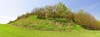
Hillfort in Kujawsko-pomorskie
The hillfort near Gawłowice is circular in shape, it covers the area of 2500 square meters. It is naturally protected from the North by the river and 13m high slope, while from the other sides there is a rampart which survived till nowdays in a good condition.
You may be viewing yesterday's version of this page. To see the most up to date information please register for a free account.
Do not use the above information on other web sites or publications without permission of the contributor.
Nearby Images from Flickr
The above images may not be of the site on this page, but were taken nearby. They are loaded from Flickr so please click on them for image credits.
Click here to see more info for this site
Nearby sites
Click here to view sites on an interactive map of the areaKey: Red: member's photo, Blue: 3rd party photo, Yellow: other image, Green: no photo - please go there and take one, Grey: site destroyed
Download sites to:
KML (Google Earth)
GPX (GPS waypoints)
CSV (Garmin/Navman)
CSV (Excel)
To unlock full downloads you need to sign up as a Contributory Member. Otherwise downloads are limited to 50 sites.
Turn off the page maps and other distractions
Nearby sites listing. In the following links * = Image available
12.7km NNE 27° Grodzisko Gruta Hillfort
17.5km E 81° Grodzisko Jabłonowo Pomorskie* Hillfort
17.7km E 85° Grodzisko Jaguszewice* Hillfort
18.5km WSW 237° Grodzisko Lipienek Hillfort
21.7km E 96° Grodzisko Lembarg* Hillfort
26.3km WSW 249° Grodzisko Storlus Hillfort
26.7km NNE 18° Grodzisko Szembruk Promontory Fort / Cliff Castle
26.8km WSW 245° Grodzisko Żygląd* Hillfort
27.5km S 177° Grodzisko Chełmonie Hillfort
27.7km S 191° Grodzisko Gronowo Hillfort
34.4km WSW 254° Grodzisko Płutowo Hillfort
38.4km NNE 23° Grodzisko Klasztorek Promontory Fort / Cliff Castle
38.6km E 99° Grodzisko Bachotek Hillfort
42.6km NE 53° Grodzisko Laseczno Hillfort
42.9km ENE 56° Grodzisko Stróżkowa Góra - Gulb Hillfort
44.2km N 4° Grodzisko Baldram Hillfort
45.1km E 88° Grodzisko Nielbark Hillfort
46.0km E 85° Grodzisko Kurzętnik* Hillfort
49.2km NE 37° Grodzisko Susz* Hillfort
55.3km ENE 73° Grodzisko Sampława* Hillfort
55.9km N 351° Brody Pomorskie Neolithic Settlement Ancient Village or Settlement
63.4km SSE 151° Grodzisko Skępe Hillfort
64.6km E 91° Grodzisko Stary Szaniec - Tarczyny Promontory Fort / Cliff Castle
64.9km NNE 31° Grodzisko Stary Dzierzgoń* Hillfort
65.3km NNW 349° Pelplin - Diabielski Kamień Natural Stone / Erratic / Other Natural Feature
View more nearby sites and additional images


 We would like to know more about this location. Please feel free to add a brief description and any relevant information in your own language.
 Wir möchten mehr über diese Stätte erfahren. Bitte zögern Sie nicht, eine kurze Beschreibung und relevante Informationen in Deutsch hinzuzufügen.
 Nous aimerions en savoir encore un peu sur les lieux. S'il vous plaît n'hesitez pas à ajouter une courte description et tous les renseignements pertinents dans votre propre langue.
 Quisieramos informarnos un poco más de las lugares. No dude en añadir una breve descripción y otros datos relevantes en su propio idioma.