<< Text Pages >> Heronbridge Roman Strip Settlement - Ancient Village or Settlement in England in Cheshire
Submitted by VirtHist on Thursday, 19 July 2007 Page Views: 11069
Multi-periodSite Name: Heronbridge Roman Strip SettlementCountry: England
NOTE: This site is 1.185 km away from the location you searched for.
County: Cheshire Type: Ancient Village or Settlement
Nearest Town: Chester Nearest Village: Eaton
Map Ref: SJ410639
Latitude: 53.168929N Longitude: 2.884037W
Condition:
| 5 | Perfect |
| 4 | Almost Perfect |
| 3 | Reasonable but with some damage |
| 2 | Ruined but still recognisable as an ancient site |
| 1 | Pretty much destroyed, possibly visible as crop marks |
| 0 | No data. |
| -1 | Completely destroyed |
| 5 | Superb |
| 4 | Good |
| 3 | Ordinary |
| 2 | Not Good |
| 1 | Awful |
| 0 | No data. |
| 5 | Can be driven to, probably with disabled access |
| 4 | Short walk on a footpath |
| 3 | Requiring a bit more of a walk |
| 2 | A long walk |
| 1 | In the middle of nowhere, a nightmare to find |
| 0 | No data. |
| 5 | co-ordinates taken by GPS or official recorded co-ordinates |
| 4 | co-ordinates scaled from a detailed map |
| 3 | co-ordinates scaled from a bad map |
| 2 | co-ordinates of the nearest village |
| 1 | co-ordinates of the nearest town |
| 0 | no data |
Internal Links:
External Links:
Ancient Village or Settlement in Cheshire.
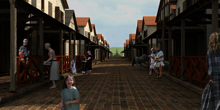
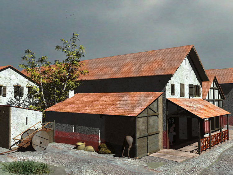
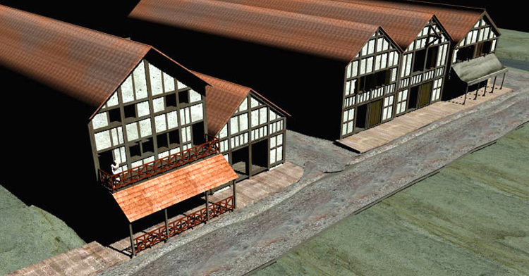
Heronbridge is the site of a Roman strip settlement that once laid just to the south of Chester on Watling Street.
The following text is from the Chester Archaeological Society...
The Roman and later site at Heronbridge stands on the west bank of the River Dee two kilometres south of Chester city centre. Rich in archaeological remians of many periods, the site potentially has much to contribute to our understanding of the early phases of Chester's historical development and also has an importance of regional, national and even international dimensions.
The site was discovered by a member of the Chester Archaeological Society in 1929 and excavations carried out by the Society over the following two years revealed the existence of a previously unknown Roman settlement, straddling the road which ran south from the legionary fortress at Chester towards Whitchurch.
Further work in later years demonstrated that the settlement was very extensive, containing numerous stone buildings, including some with hypocausts, as well as at least one shrine or temple. Recent geophysical surveying has shown it to be nearly a kilometre in length.
Founded in the late first century, the site was continuously occupied until at least AD 350. The pattern of two major civil settlements beside a legionary fortress (the other being the one immediately outside the defences at Chester) is one that is repeated in many other provinces, although the precise reasons for this are a matter for speculation. Unlike other settlements of this type, Heronbridge is free of modern settlement and has the potential, through further investigation, to make a substantial contribution towards our understanding of this phenomenon. Only a small percentage of the settlement has been explored and there is still much to learn.
Heronbridge may also be important for the early post-Roman period. The most obvious feature of the site today is a grass-grown mound which encloses a crescent-shaped area of some fourteen acres between the Roman road and the river. Excavation has shown this to be defensive earthwork, possibly retained by a drystone revetment at the front, accompanied by a deep ditch. Apart from the fact that it overlies ruined buildings of the Roman settlement, its date is uncertain. However, the discovery beneath the earthwork of some twenty or more human burials - all apparently battle casulaties - has given rise to the suggestion that it was an encampment constructed by King Aethelfrith of Northumbria following his victory over the forces of Gwynedd and Powys at the Battle of Chester c AD 613. The eccles element in the name of the neighbouring village of Eccleston is considered to denote the presence of an early (sub-Roman) Christian community while the circular shape of the churchyard here is also thought to indicate an early foundation.
You may be viewing yesterday's version of this page. To see the most up to date information please register for a free account.


Do not use the above information on other web sites or publications without permission of the contributor.
Nearby Images from Geograph Britain and Ireland:

©2016(licence)

©2013(licence)

©2016(licence)

©2016(licence)

©2022(licence)
The above images may not be of the site on this page, they are loaded from Geograph.
Please Submit an Image of this site or go out and take one for us!
Click here to see more info for this site
Nearby sites
Key: Red: member's photo, Blue: 3rd party photo, Yellow: other image, Green: no photo - please go there and take one, Grey: site destroyed
Download sites to:
KML (Google Earth)
GPX (GPS waypoints)
CSV (Garmin/Navman)
CSV (Excel)
To unlock full downloads you need to sign up as a Contributory Member. Otherwise downloads are limited to 50 sites.
Turn off the page maps and other distractions
Nearby sites listing. In the following links * = Image available
1.7km NNW 348° Chester Minerva shrine* Ancient Temple (SJ40676561)
2.1km NNW 336° Roodee Cross, Chester Race Course* Ancient Cross (SJ4017065847)
2.1km NNW 345° Grosvenor Museum* Museum (SJ40466595)
2.2km N 354° Roman Garden & Hypocaust (Chester)* Ancient Village or Settlement (SJ40786607)
2.2km N 357° St John the Baptist Church, Chester* Ancient Cross (SJ40916613)
2.3km N 355° Roman Amphitheatre (Chester)* Ancient Temple (SJ40836616)
2.3km N 6° Billy Hobby's Well* Holy Well or Sacred Spring (SJ4127766202)
2.5km NNW 348° Dewa Roman Experience* Museum (SJ405663)
5.5km S 186° Poulton Timber Circle* Ancient Village or Settlement (SJ4033558472)
7.4km SW 214° St Peter's Well (Denbighshire) Holy Well or Sacred Spring (SJ36735784)
7.8km NE 36° St Plegmund's Well* Holy Well or Sacred Spring (SJ457701)
7.8km S 179° Knowl Plantation Barrow Cemetery (SJ410561)
8.1km S 179° Churton* Long Barrow (SJ411558)
8.7km E 89° Brookhouse Farm Ancient Village or Settlement (SJ497639)
10.7km NW 311° Modern Stones at Deeside Industrial Area* Modern Stone Circle etc (SJ330711)
10.7km SE 143° St Winefride's (Clutton)* Holy Well or Sacred Spring (SJ47395524)
10.9km SW 215° The Atropos Altar Stone* Sculptured Stone (SJ34645497)
11.1km NNE 16° St Mary (Thornton Le Moors)* Ancient Cross (SJ44157455)
11.4km WSW 240° Hope Church Early Medieval Stones* Ancient Cross (SJ310584)
11.5km SSE 152° Carden Park* Cave or Rock Shelter (SJ463537)
11.6km SW 235° Caer Estyn* Hillfort (SJ314574)
11.7km SSE 152° Carden Park Barrow Round Barrow(s) (SJ46365352)
12.0km WSW 244° Park in the Past* Museum (SJ301588)
12.6km SSW 203° Borras Quarry Neolithic Village Ancient Village or Settlement (SJ35855243)
12.6km ENE 73° Kelsborrow Castle* Hillfort (SJ5315567509)
View more nearby sites and additional images


 We would like to know more about this location. Please feel free to add a brief description and any relevant information in your own language.
 Wir möchten mehr über diese Stätte erfahren. Bitte zögern Sie nicht, eine kurze Beschreibung und relevante Informationen in Deutsch hinzuzufügen.
 Nous aimerions en savoir encore un peu sur les lieux. S'il vous plaît n'hesitez pas à ajouter une courte description et tous les renseignements pertinents dans votre propre langue.
 Quisieramos informarnos un poco más de las lugares. No dude en añadir una breve descripción y otros datos relevantes en su propio idioma.