<< Our Photo Pages >> Grafheuvel Heerde (45435) - Round Barrow(s) in Netherlands in Gelderland
Submitted by XIII on Thursday, 06 August 2015 Page Views: 936
Neolithic and Bronze AgeSite Name: Grafheuvel Heerde (45435)Country: Netherlands
NOTE: This site is 6.387 km away from the location you searched for.
Province: Gelderland Type: Round Barrow(s)
Nearest Town: Heerde
Latitude: 52.390996N Longitude: 5.998310E
Condition:
| 5 | Perfect |
| 4 | Almost Perfect |
| 3 | Reasonable but with some damage |
| 2 | Ruined but still recognisable as an ancient site |
| 1 | Pretty much destroyed, possibly visible as crop marks |
| 0 | No data. |
| -1 | Completely destroyed |
| 5 | Superb |
| 4 | Good |
| 3 | Ordinary |
| 2 | Not Good |
| 1 | Awful |
| 0 | No data. |
| 5 | Can be driven to, probably with disabled access |
| 4 | Short walk on a footpath |
| 3 | Requiring a bit more of a walk |
| 2 | A long walk |
| 1 | In the middle of nowhere, a nightmare to find |
| 0 | No data. |
| 5 | co-ordinates taken by GPS or official recorded co-ordinates |
| 4 | co-ordinates scaled from a detailed map |
| 3 | co-ordinates scaled from a bad map |
| 2 | co-ordinates of the nearest village |
| 1 | co-ordinates of the nearest town |
| 0 | no data |
Be the first person to rate this site - see the 'Contribute!' box in the right hand menu.
Internal Links:
External Links:
I have visited· I would like to visit
XIII visited on 29th Jun 2022 - their rating: Cond: 3 Amb: 4 Access: 4 Site is completely overgrown and needs attention
 (PID:244208)")
Rijksmonument (national monument) number: 45435
You may be viewing yesterday's version of this page. To see the most up to date information please register for a free account.
 (PID:244207)")
Do not use the above information on other web sites or publications without permission of the contributor.
Nearby Images from Flickr
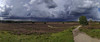
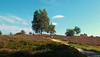
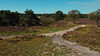
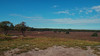
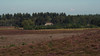
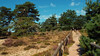
The above images may not be of the site on this page, but were taken nearby. They are loaded from Flickr so please click on them for image credits.
Click here to see more info for this site
Nearby sites
Click here to view sites on an interactive map of the areaKey: Red: member's photo, Blue: 3rd party photo, Yellow: other image, Green: no photo - please go there and take one, Grey: site destroyed
Download sites to:
KML (Google Earth)
GPX (GPS waypoints)
CSV (Garmin/Navman)
CSV (Excel)
To unlock full downloads you need to sign up as a Contributory Member. Otherwise downloads are limited to 50 sites.
Turn off the page maps and other distractions
Nearby sites listing. In the following links * = Image available
2.7km S 191° Grafheuvel Epe (45352) Round Barrow(s)
4.3km SW 227° Grafheuvel Epe (45337)* Round Barrow(s)
4.7km SW 230° Grafheuvel Epe (45336) Round Barrow(s)
5.2km SW 219° Grafheuvel Tongeren (45341) Round Barrow(s)
5.8km WSW 236° Grafheuvels Tongeren (45349)* Round Barrow(s)
6.5km WSW 236° Grafheuvel Tongeren (45350)* Round Barrow(s)
7.9km SSW 201° Grafheuvel Schaveren (45364) Round Barrow(s)
7.9km SSW 208° Grafheuvel Schaveren (45366) Round Barrow(s)
8.2km SSW 203° Grafheuvel Schaveren (45365) Round Barrow(s)
10.2km SW 226° Grafheuvel Gortel (45356) Round Barrow(s)
10.4km SSW 206° Grafheuvels Gortel (45360) Round Barrow(s)
12.0km SSW 210° Grafheuvel Niersen (45359) Round Barrow(s)
12.1km SW 233° Grafheuvel Vierhouten (45502) Round Barrow(s)
12.4km SW 231° Grafheuvel Vierhouten (45820) Round Barrow(s)
12.7km WNW 284° Zwerfsteen Doornspijk Natural Stone / Erratic / Other Natural Feature
12.8km SSW 210° Grafheuvels Niersen (45361) Round Barrow(s)
13.2km SW 215° Grafheuvel Niersen (45353) Round Barrow(s)
13.7km SW 223° Grafheuvel Gortel (45363) Round Barrow(s)
14.2km WSW 242° Grafheuvel Vierhouten (45816) Round Barrow(s)
14.5km SW 233° Grafheuvel Vierhouten (45501) Round Barrow(s)
15.5km WSW 249° Grafheuvels Nunspeet (45813) Round Barrow(s)
16.2km SSW 198° Grafheuvel Apeldoorn (45194) Round Barrow(s)
16.2km SSW 198° Grafheuvel Wiesel (45196) Round Barrow(s)
16.3km SSW 197° Grafheuvel Wiesel (45183) Round Barrow(s)
16.4km SW 232° Grafheuvels Elspeet (45818) Round Barrow(s)
View more nearby sites and additional images


 We would like to know more about this location. Please feel free to add a brief description and any relevant information in your own language.
 Wir möchten mehr über diese Stätte erfahren. Bitte zögern Sie nicht, eine kurze Beschreibung und relevante Informationen in Deutsch hinzuzufügen.
 Nous aimerions en savoir encore un peu sur les lieux. S'il vous plaît n'hesitez pas à ajouter une courte description et tous les renseignements pertinents dans votre propre langue.
 Quisieramos informarnos un poco más de las lugares. No dude en añadir una breve descripción y otros datos relevantes en su propio idioma.