 with our Megalithic Portal iPhone app")

, Aubrey Burl")
<< Our Photo Pages Pen-Twyn - Hillfort in Wales in Monmouthshire (Sir Fynwy)
Submitted by Marko on Tuesday, 16 June 2026 Page Views: 5389
Iron Age and Later PrehistorySite Name: Pen-TwynCountry: Wales County: Monmouthshire (Sir Fynwy) Type: Hillfort
Nearest Town: Abergavenny Nearest Village: Crucorney Fawr
Map Ref: SO3210023000 Landranger Map Number: 161
Latitude: 51.901387N Longitude: 2.98829W
Condition:
| 5 | Perfect |
| 4 | Almost Perfect |
| 3 | Reasonable but with some damage |
| 2 | Ruined but still recognisable as an ancient site |
| 1 | Pretty much destroyed, possibly visible as crop marks |
| 0 | No data. |
| -1 | Completely destroyed |
| 5 | Superb |
| 4 | Good |
| 3 | Ordinary |
| 2 | Not Good |
| 1 | Awful |
| 0 | No data. |
| 5 | Can be driven to, probably with disabled access |
| 4 | Short walk on a footpath |
| 3 | Requiring a bit more of a walk |
| 2 | A long walk |
| 1 | In the middle of nowhere, a nightmare to find |
| 0 | No data. |
| 5 | co-ordinates taken by GPS or official recorded co-ordinates |
| 4 | co-ordinates scaled from a detailed map |
| 3 | co-ordinates scaled from a bad map |
| 2 | co-ordinates of the nearest village |
| 1 | co-ordinates of the nearest town |
| 0 | no data |
Internal Links:
External Links:
I have visited· I would like to visit
Alastairha visited on 12th Jun 2026 - their rating: Amb: 4 Access: 3
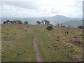
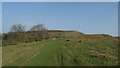
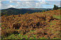
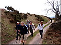
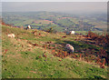
Marko visited (still working on) on 16th Aug 2015 - their rating: Cond: 4 Amb: 4 Access: 3 Half a hill fort is better than none! I intended to visit this site whilst on holiday nearby.Was out on another walk and saw the hillfort,but as i wasn't expecting to visit as soon i hadn't got my notes with me. - Fatal,as i thought that what was actualy a central bank was the South East limit of the fort.Only realised later that i'd missed the chance to see about half of the defences.
However,the half of the hillfort i did see was worth the climb up from Oldcastle.The North West rampart was under bracken but was still impressive (as was the central bank).A modern track runs right alongside the South Western rampart.The North Eastern side is defended by the natural steep slope of Hatterall Hill.
Average ratings for this site from all visit loggers: Ambience: 4 Access: 3
")
Page originally by Vicky.
You may be viewing yesterday's version of this page. To see the most up to date information please register for a free account.
")
Do not use the above information on other web sites or publications without permission of the contributor.
Nearby Images from Geograph Britain and Ireland:
©2013(licence)
©2018(licence)
©2010(licence)
©2015(licence)
©2011(licence)
The above images may not be of the site on this page, they are loaded from Geograph.
Please Submit an Image of this site or go out and take one for us!
Click here to see more info for this site
Nearby sites
Key: Red: member's photo, Blue: 3rd party photo, Yellow: other image, Green: no photo - please go there and take one, Grey: site destroyed
Download sites to:
KML (Google Earth)
GPX (GPS waypoints)
CSV (Garmin/Navman)
CSV (Excel)
To unlock full downloads you need to sign up as a Contributory Member. Otherwise downloads are limited to 50 sites.
Turn off the page maps and other distractions
Nearby sites listing. In the following links * = Image available
2.2km W 280° St Martin's Church (Cwmyoy)* Ancient Cross (SO29902340)
2.9km WSW 248° Twyn-y-Gaer (Monmouthshire) Hillfort (SO2938721948)
4.2km W 262° Partrishow Churchyard Cross* Ancient Cross (SO2788822434)
4.3km W 262° Ffynnon Ishow* Holy Well or Sacred Spring (SO2784322428)
4.4km N 7° St. Clodock's Well* Holy Well or Sacred Spring (SO32692738)
4.5km N 6° Clodock Inscribed Stone* Carving (SO32642751)
4.6km WNW 295° Llanthony Barrow Cemetery (SO2825)
4.7km WNW 301° Garn Wen (Monmouthshire)* Stone Circle (SO28072545)
4.7km SW 220° Blaenawey Well (Bettws)* Holy Well or Sacred Spring (SO290194)
4.8km SSE 167° Ysgyryd Fawr* Hillfort (SO33111827)
5.5km S 186° Trillech Stone Row / Alignment (SO314175)
6.1km W 273° Disgwylfa, Cairn I* Cairn (SO2597023440)
6.1km NNW 338° Wiral Cairn* Cairn (SO2985028710)
6.7km S 187° St Teilo's Church (Llantilio Pertholey)* Ancient Cross (SO31141633)
7.0km NNW 336° Crucorney Fawr 2 Round Cairn (SO293294)
7.1km ESE 106° Grosmont Fawr Hillfort (SO389210)
7.1km SSW 200° Twyn yr Allt* Ancient Village or Settlement (SO296163)
7.2km SE 143° St Gwytherine's Grave Stone* Early Christian Sculptured Stone (SO364172)
7.5km NNW 335° Crucorney Fawr 1 Round Cairn (SO290298)
7.5km SE 142° Llanvetherine Holy Well* Holy Well or Sacred Spring (SO36671704)
7.7km WNW 288° Nant Yr Ychen Round Cairn* Cairn (SO2476025470)
8.4km E 80° Grosmont Churchyard Cross* Ancient Cross (SO40462432)
8.5km NNW 347° Llanveyno Crosses* Ancient Cross (SO3031131361)
9.0km SSW 192° Abergavenny Priory Cross* Ancient Cross (SO3009514184)
9.3km SSW 192° Abergavenny Museum* Museum (SO2995913943)
View more nearby sites and additional images


 We would like to know more about this location. Please feel free to add a brief description and any relevant information in your own language.
 Wir möchten mehr über diese Stätte erfahren. Bitte zögern Sie nicht, eine kurze Beschreibung und relevante Informationen in Deutsch hinzuzufügen.
 Nous aimerions en savoir encore un peu sur les lieux. S'il vous plaît n'hesitez pas à ajouter une courte description et tous les renseignements pertinents dans votre propre langue.
 Quisieramos informarnos un poco más de las lugares. No dude en añadir una breve descripción y otros datos relevantes en su propio idioma.