


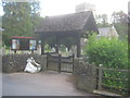
<< Our Photo Pages >> St Teilo's Church (Llantilio Pertholey) - Ancient Cross in Wales in Monmouthshire (Sir Fynwy)
Submitted by Anne T on Saturday, 02 February 2019 Page Views: 1391
Early MedievalSite Name: St Teilo's Church (Llantilio Pertholey)Country: Wales
NOTE: This site is 0.563 km away from the location you searched for.
County: Monmouthshire (Sir Fynwy) Type: Ancient Cross
Nearest Town: Abergavenny Nearest Village: Llantilio Pertholey
Map Ref: SO31141633
Latitude: 51.841309N Longitude: 3.000908W
Condition:
| 5 | Perfect |
| 4 | Almost Perfect |
| 3 | Reasonable but with some damage |
| 2 | Ruined but still recognisable as an ancient site |
| 1 | Pretty much destroyed, possibly visible as crop marks |
| 0 | No data. |
| -1 | Completely destroyed |
| 5 | Superb |
| 4 | Good |
| 3 | Ordinary |
| 2 | Not Good |
| 1 | Awful |
| 0 | No data. |
| 5 | Can be driven to, probably with disabled access |
| 4 | Short walk on a footpath |
| 3 | Requiring a bit more of a walk |
| 2 | A long walk |
| 1 | In the middle of nowhere, a nightmare to find |
| 0 | No data. |
| 5 | co-ordinates taken by GPS or official recorded co-ordinates |
| 4 | co-ordinates scaled from a detailed map |
| 3 | co-ordinates scaled from a bad map |
| 2 | co-ordinates of the nearest village |
| 1 | co-ordinates of the nearest town |
| 0 | no data |
Be the first person to rate this site - see the 'Contribute!' box in the right hand menu.
Internal Links:
External Links:
I have visited· I would like to visit
geoffstickland has visited here
 (PID:197785)")
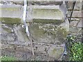
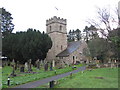
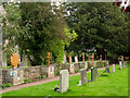
The Journal of Antiquities includes an entry for St Teilo’s Church, Llantilio Pertholey, Monmouthshire (Sir Fynwy). Whilst the church itself is largely 13th century, its crude altar (which used to be a stile!) has two consecration crosses. The Journal gives us background information about the church, adding that there may have been a place of worship as far back as the 8th century. It is known that a holy man named Bevan was a follower of St Teilo (Theliau) who died at Llandeilo-Fawr in Carmarthenshire in 560AD. Bevan is known to have been buried at this site.
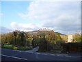
The church is recorded as Coflein NPRN 307314 which gives architectural details for the church, including wallpaintings. The Journal adds the church sits in the shadow of Skirrid Fawr, which is considered by the locals to be a holy mountain, gives us a walkthrough of some of the other features of the church, and lists reference sources for more information.
Note: Have you visited this site? Do you have any photographs or information to add?
You may be viewing yesterday's version of this page. To see the most up to date information please register for a free account.
Do not use the above information on other web sites or publications without permission of the contributor.
Nearby Images from Geograph Britain and Ireland:
©2022(licence)
©2017(licence)
©2016(licence)
©2015(licence)
©2015(licence)
The above images may not be of the site on this page, they are loaded from Geograph.
Please Submit an Image of this site or go out and take one for us!
Click here to see more info for this site
Nearby sites
Key: Red: member's photo, Blue: 3rd party photo, Yellow: other image, Green: no photo - please go there and take one, Grey: site destroyed
Download sites to:
KML (Google Earth)
GPX (GPS waypoints)
CSV (Garmin/Navman)
CSV (Excel)
To unlock full downloads you need to sign up as a Contributory Member. Otherwise downloads are limited to 50 sites.
Turn off the page maps and other distractions
Nearby sites listing. In the following links * = Image available
1.2km NNE 12° Trillech Stone Row / Alignment (SO314175)
1.5km W 268° Twyn yr Allt* Ancient Village or Settlement (SO296163)
2.4km SSW 205° Abergavenny Priory Cross* Ancient Cross (SO3009514184)
2.6km SSW 199° Priory Well (Abergavenny)* Holy Well or Sacred Spring (SO30231387)
2.7km SSW 205° Abergavenny Museum* Museum (SO2995913943)
2.8km NE 45° Ysgyryd Fawr* Hillfort (SO33111827)
3.5km SW 222° Llanfoist Standing Stone* Standing Stone (Menhir) (SO28781379)
3.7km NW 324° Blaenawey Well (Bettws)* Holy Well or Sacred Spring (SO290194)
5.3km E 80° St Gwytherine's Grave Stone* Early Christian Sculptured Stone (SO364172)
5.6km E 82° Llanvetherine Holy Well* Holy Well or Sacred Spring (SO36671704)
5.9km NNW 342° Twyn-y-Gaer (Monmouthshire) Hillfort (SO2938721948)
6.0km ESE 111° St Mable's Churchyard Cross, Llanvapley* Ancient Cross (SO3668114076)
6.1km SW 222° Blorenge Cairn* Round Cairn (SO26991186)
6.7km N 7° Pen-Twyn* Hillfort (SO3210023000)
6.9km NNW 331° Partrishow Churchyard Cross* Ancient Cross (SO2788822434)
6.9km NNW 331° Ffynnon Ishow* Holy Well or Sacred Spring (SO2784322428)
7.1km WSW 245° Bedd y Gwr Hir* Standing Stone (Menhir) (SO246134)
7.2km N 349° St Martin's Church (Cwmyoy)* Ancient Cross (SO29902340)
7.2km SW 225° Blorenge West Flank - Y Blorens* Not Known (by us) (SO260113)
7.3km W 281° Golden Grove* Standing Stone (Menhir) (SO2396217829)
7.5km SSW 212° Carn y Defaid (N)* Cairn (SO27081004)
7.6km SSW 212° Carn y Defaid (S)* Cairn (SO27040997)
7.6km S 178° Ffynnon Gofer (Llanover)* Holy Well or Sacred Spring (SO313087)
7.8km WNW 288° Coed Ynys Faen* Standing Stones (SO237188)
7.9km W 273° Cwrt-y-Gollen* Standing Stone (Menhir) (SO2324116860)
View more nearby sites and additional images


 We would like to know more about this location. Please feel free to add a brief description and any relevant information in your own language.
 Wir möchten mehr über diese Stätte erfahren. Bitte zögern Sie nicht, eine kurze Beschreibung und relevante Informationen in Deutsch hinzuzufügen.
 Nous aimerions en savoir encore un peu sur les lieux. S'il vous plaît n'hesitez pas à ajouter une courte description et tous les renseignements pertinents dans votre propre langue.
 Quisieramos informarnos un poco más de las lugares. No dude en añadir una breve descripción y otros datos relevantes en su propio idioma.