<< Our Photo Pages >> Stansted Airport Stone - Natural Stone / Erratic / Other Natural Feature in England in Essex

Submitted by Thorgrim on Monday, 24 September 2018  Page Views: 7592

Natural PlacesSite Name: Stansted Airport Stone Alternative Name: Takely stone
Country: England
NOTE: This site is 5.958 km away from the location you searched for.

County: Essex Type: Natural Stone / Erratic / Other Natural Feature
Nearest Town: Bishops Stortford  Nearest Village: Takeley
Map Ref: TL561212
Latitude: 51.867540N  Longitude: 0.265817E
Condition:
5Perfect
4Almost Perfect
3Reasonable but with some damage
2Ruined but still recognisable as an ancient site
1Pretty much destroyed, possibly visible as crop marks
0No data.
-1Completely destroyed
5 Ambience:
5Superb
4Good
3Ordinary
2Not Good
1Awful
0No data.
3 Access:
5Can be driven to, probably with disabled access
4Short walk on a footpath
3Requiring a bit more of a walk
2A long walk
1In the middle of nowhere, a nightmare to find
0No data.
5 Accuracy:
5co-ordinates taken by GPS or official recorded co-ordinates
4co-ordinates scaled from a detailed map
3co-ordinates scaled from a bad map
2co-ordinates of the nearest village
1co-ordinates of the nearest town
0no data
4

Internal Links:
External Links:

Stansted Airport Stone
Stansted Airport Stone submitted by Thorgrim : The stone excavated from a Bronze Age site at Stansted Airport, now lies on the green at the cross roads in nearby Takely. (Vote or comment on this photo)
This sarsen stone was discovered in 2000 by archaeologists in a pit which was part of a complex of Bronze Age dwellings at Stansted Airport. It had clearly been placed in this pit by Bronze Age people, some 3,500 years ago, although for what purpose has yet to be established. It's now positioned besides the village sign at the main crossroads in the village of Takely. This stone was likely to have had some significance to the people who buried it - could it have been a standing stone?

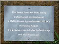
Sarsen is only found as an uncommon glacial erratic in Essex. However, the sharp edges and polished surfaces seems to indicate human intervention and dressing. It seems inconceivable that such a regular "square" stone could become that shape from the action of ice and after being dragged along in a glacier.
You may be viewing yesterday's version of this page. To see the most up to date information please register for a free account.


Stansted Airport Stone
Stansted Airport Stone submitted by Thorgrim : This sarsen seems very square cut to be a natural glacial erratic (2 comments - Vote or comment on this photo)

Stansted Airport Stone
Stansted Airport Stone submitted by Thorgrim : Attractive small plate gives relevant information. (Vote or comment on this photo)

Stansted Airport Stone
Stansted Airport Stone submitted by Thorgrim : Highly polished smooth surface with banding in the rock. Can this be natural? Surely not. (Vote or comment on this photo)

Do not use the above information on other web sites or publications without permission of the contributor.

Nearby Images from Geograph Britain and Ireland:
TL5621 : Plaque on erratic at Takeley by Thomas Nugent
by Thomas Nugent
©2007(licence)
TL5621 : Takeley protest banner by Thomas Nugent
by Thomas Nugent
©2008(licence)
TL5621 : Lights on Dunmow Road, Takeley by David Howard
by David Howard
©2012(licence)
TL5621 : Takeley protest banner by Thomas Nugent
by Thomas Nugent
©2010(licence)
TL5621 : Crossroads in Takeley by Trevor Harris
by Trevor Harris
©2022(licence)

The above images may not be of the site on this page, they are loaded from Geograph.
Please Submit an Image of this site or go out and take one for us!


Click here to see more info for this site

Nearby sites

Click here to view sites on an interactive OS map

Key: Red: member's photo, Blue: 3rd party photo, Yellow: other image, Green: no photo - please go there and take one, Grey: site destroyed

Download sites to:
KML (Google Earth)
GPX (GPS waypoints)
CSV (Garmin/Navman)
CSV (Excel)

To unlock full downloads you need to sign up as a Contributory Member. Otherwise downloads are limited to 50 sites.


Turn off the page maps and other distractions

Nearby sites listing. In the following links * = Image available
 2.4km WSW 237° Hatfield Forest Puddingstones* Natural Stone / Erratic / Other Natural Feature (TL541198)
 3.0km WSW 256° Hatfield Forest* Ancient Village or Settlement (TL532204)
 5.6km WNW 288° Birchanger* Early Christian Sculptured Stone (TL507228)
 6.4km NE 38° Tilty Puddingstone* Natural Stone / Erratic / Other Natural Feature (TL599264)
 7.0km NNW 330° Ugley Green Puddingstone* Natural Stone / Erratic / Other Natural Feature (TL5242327126)
 7.1km W 272° Glasscock Stone* Natural Stone / Erratic / Other Natural Feature (TL4894821169)
 7.6km WSW 245° Wallbury Camp* Hillfort (TL493178)
 11.4km NNW 347° Widdington Puddingstone* Natural Stone / Erratic / Other Natural Feature (TL532322)
 11.5km S 173° Beauchamp Roding Puddingstone* Marker Stone (TL578098)
 11.7km E 101° Felsted Misc. Earthwork (TL677193)
 12.1km N 357° Debden Pudding Stone* Natural Stone / Erratic / Other Natural Feature (TL550333)
 12.7km WNW 293° Patmore Heath* Marker Stone (TL44262581)
 12.9km NNW 344° Newport Puddingstone* Natural Stone / Erratic / Other Natural Feature (TL521335)
 12.9km SSW 197° High Laver Puddingstone* Natural Stone / Erratic / Other Natural Feature (TL527087)
 13.0km SW 221° Harlow Barrow* Round Barrow(s) (TL478112)
 13.0km SW 221° Matching Cursus Cursus (TL47791113)
 13.0km SW 222° Harlow Cursus Cursus (TL477112)
 13.2km NNW 340° Wicken Bonhunt Puddingstone* Natural Stone / Erratic / Other Natural Feature (TL511334)
 13.8km SSW 202° Magdalen Laver Puddingstone* Marker Stone (TL513083)
 13.9km W 273° Caley Wood Misc. Earthwork (TL422215)
 14.0km NW 322° Clavering Castle* Misc. Earthwork (TL471319)
 14.3km NNW 345° Leper Stone* Standing Stone (Menhir) (TL520349)
 15.0km SE 142° Roxwell Puddingstone Marker Stone (TL657097)
 15.3km NNW 332° Arkesden Puddingstones* Natural Stone / Erratic / Other Natural Feature (TL485345)
 15.7km SSE 163° Watling Street* Ancient Trackway (TL611063)
View more nearby sites and additional images

<< Holy Trinity (Old Bewick)

Carn Llundain (South) >>

Please add your thoughts on this site

Explore Green Men

Explore Green Men

Sponsors

Auto-Translation (Google)

Translate from English into:

"Stansted Airport Stone" | Login/Create an Account | 3 News and Comments
  
Go back to top of page    Comments are owned by the poster. We aren't responsible for their content.
Re: Stansted Airport Stone by Anonymous on Friday, 28 September 2018
Caesar’s Camp
The Caesar’s Camp building at Heathrow, Middlesex, ‘A Celtic temple’, was excavated in the mid nineteen-forties at the future site of London airport. Characterised by its rectangular form, the timber post building is considered representative of the newly arrived European Celtic tribal traditions. The presumed basis of design incorporates a 3:4:5 sided triangle that defined the central inner area of the building. The surrounding outer area could have served as an audience observation zone.
HEATHROW TEMPLE, c.500 BC

Antiquarian Dr William Stukeley visited the Middlesex site on April 18th 1723. His sketch of that date showed earthworks with an exterior ditch and rectangular mound within. The central area was shown to be essentially flat. The site was known as “Caesars Camp on Hounfow heath”
In advance of the construction of London Heathrow airport in the late nineteen-forties, an archaeological excavation team found traces of an Iron Age building of considerable size. Almost rectangular in plan, about 20 metres by 18 metres, the Iron Age structure had originally been built with inner and outer walls of timber posts. An entrance faced eastwards. It can be reasonably be assumed the structure was roofed with straw thatch, the apex supported by the six innermost large diameter posts and the outer perimeter by fifty or more slender wall posts. The timber postholes varied in size, those within the inner courtyard posts being quite large, perhaps a metre diameter. The outer wall postholes indicated posts perhaps half a metre diameter. Scattered additional postholes within and without the principal walls may have been supplementary posts to support a roof or perhaps extra features such as an entrance portico, or ornamental arches.


The building is presumed to have been a Celtic temple, the rectangular inner sanctum defined and surrounded by six large diameter posts, an inner area for ceremonial purposes of about twelve square metres. Still under the same roof but between the inner and outer walls, the surrounding perimeter space would have been large enough to accommodate up to fifty witnesses to any ceremonies, maybe standing room only, but witnesses nonetheless. Alternatively, the inner space could have been the tribal chief’s area for the privileged few, carousing, eating and drinking. The surrounding space would have allowed less important people to join the feasting and merriment but at a respectful distance from the nobility.
The elements of the original geometric design and its dimensions have been reconstructed as defined straight lines. Note these have been drawn to touch the posts, not through the centre of each principal post as practised today. The numerical lengths are quoted in faethms. Inner space post positions appear to have been defined by a 3, 4, 5 faethm right-angled triangle.

My jpeg illustration is not accepted by your pane, nevertheless try Google in hope of a view.
Wonder whether the Stansted site and Caesar's camp constructs have anything in common? Sincerely, Neil L. Thomas
[ Reply to This ]

Sarsen stones in Essex by Andy B on Monday, 24 September 2018
(User Info | Send a Message)
GeoEssex Factsheet No 1 Compiled by Gerald Lucy

Sarsen stones
By the roadside in many parts of north and central Essex are very large sandstone boulders. Although difficult to move they have usually been placed here by farmers over the years, having been found in the fields and regarded as an inconvenience and liable to break agricultural machinery. These boulders are known as sarsen stones or sarsens. The word sarsen originates in Wiltshire, where these stones also occur, and may be derived from the word ‘saracen’, which means stranger. They must have been regarded as a strange sight in the landscape, especially on the grassy chalk downs where their pale colour would have made them conspicuous. An old name for sarsen stones is ‘greywethers’, so-called because of their resemblance, from a distance, to a flock of sheep

Uses of Sarsens in Essex
Sarsens have been employed as way markers for centuries but they have had other uses. In Dedham churchyard there is an inscribed sarsen grave stone which dates back to 1690. Many north Essex churches have sarsens in their foundations but the most remarkable site is at Alphamstone where at least 11 large sarsens in and around the churchyard provide strong evidence that the church may have been built on a pagan site, possibly a stone circle.
http://www.megalithic.co.uk/article.php?sid=10813 - also in the Old Stones guide

Adjacent to the crossroads at Takeley is a sarsen with a very unusual history. This stone was discovered in 2000 by archaeologists in a pit which was part of a complex of Bronze Age dwellings at Stansted Airport. It had clearly been placed in this pit by Bronze Age Man, some 3,500 years ago, although for what purpose has yet to be established.

More about sarsens in Essex
http://www.geoessex.org.uk/files/geoessex_factsheet_1_-_sarsen_stones.pdf
[ Reply to This ]

Re: Stansted Airport Stone by Chalkblue on Saturday, 16 August 2008
(User Info | Send a Message)
My family used to farm land which is now under Stansted Airport. The old farm house is still standing on the edge of the airport and some years ago, when I visited it, the present tenants told me they were mystified by occasional visitors asking directions to "the pagan stone". My mother, who died last year at 97 years old, remembered a stone which she and other children used to play on. She said they called it "Queen (somebody's) gravestone" Could this have been the Stansted Airport Stone, now relocated to the crossroads at Takeley?

Does anybody know whether there is a record of the exact original location of this stone?

I very much regret that I cannot remember the name of the "Queen" my mother mentioned.
[ Reply to This ]

Your Name: Anonymous [ Register Now ]
Subject:


Add your comment or contribution to this page. Spam or offensive posts are deleted immediately, don't even bother

<<< What is five plus one as a number? (Please type the answer to this question in the little box on the left)
You can also embed videos and other things. For Youtube please copy and paste the 'embed code'.
For Google Street View please include Street View in the text.
Create a web link like this: <a href="https://www.megalithic.co.uk">This is a link</a>  

Allowed HTML is:
<p> <b> <i> <a> <img> <em> <br> <strong> <blockquote> <tt> <li> <ol> <ul> <object> <param> <embed> <iframe>

We would like to know more about this location. Please feel free to add a brief description and any relevant information in your own language.
Wir möchten mehr über diese Stätte erfahren. Bitte zögern Sie nicht, eine kurze Beschreibung und relevante Informationen in Deutsch hinzuzufügen.
Nous aimerions en savoir encore un peu sur les lieux. S'il vous plaît n'hesitez pas à ajouter une courte description et tous les renseignements pertinents dans votre propre langue.
Quisieramos informarnos un poco más de las lugares. No dude en añadir una breve descripción y otros datos relevantes en su propio idioma.