<< Our Photo Pages >> Abergavenny Priory Cross - Ancient Cross in Wales in Monmouthshire
Submitted by dooclay on Monday, 29 July 2024 Page Views: 273
Early Medieval (Dark Age)Site Name: Abergavenny Priory CrossCountry: Wales
NOTE: This site is 0.54 km away from the location you searched for.
County: Monmouthshire Type: Ancient Cross
Nearest Town: Abergavenny
Map Ref: SO3009514184
Latitude: 51.821887N Longitude: 3.015639W
Condition:
| 5 | Perfect |
| 4 | Almost Perfect |
| 3 | Reasonable but with some damage |
| 2 | Ruined but still recognisable as an ancient site |
| 1 | Pretty much destroyed, possibly visible as crop marks |
| 0 | No data. |
| -1 | Completely destroyed |
| 5 | Superb |
| 4 | Good |
| 3 | Ordinary |
| 2 | Not Good |
| 1 | Awful |
| 0 | No data. |
| 5 | Can be driven to, probably with disabled access |
| 4 | Short walk on a footpath |
| 3 | Requiring a bit more of a walk |
| 2 | A long walk |
| 1 | In the middle of nowhere, a nightmare to find |
| 0 | No data. |
| 5 | co-ordinates taken by GPS or official recorded co-ordinates |
| 4 | co-ordinates scaled from a detailed map |
| 3 | co-ordinates scaled from a bad map |
| 2 | co-ordinates of the nearest village |
| 1 | co-ordinates of the nearest town |
| 0 | no data |
Internal Links:
External Links:
")
Nothing is mentioned of this site on Coflein, possibly as only the base remains?
You may be viewing yesterday's version of this page. To see the most up to date information please register for a free account.
Do not use the above information on other web sites or publications without permission of the contributor.
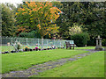
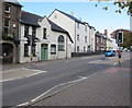
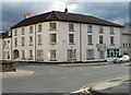
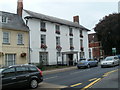
Nearby Images from Geograph Britain and Ireland:
©2016(licence)
©2018(licence)

©2010(licence)
©2010(licence)
©2011(licence)
The above images may not be of the site on this page, they are loaded from Geograph.
Please Submit an Image of this site or go out and take one for us!
Click here to see more info for this site
Nearby sites
Key: Red: member's photo, Blue: 3rd party photo, Yellow: other image, Green: no photo - please go there and take one, Grey: site destroyed
Download sites to:
KML (Google Earth)
GPX (GPS waypoints)
CSV (Garmin/Navman)
CSV (Excel)
To unlock full downloads you need to sign up as a Contributory Member. Otherwise downloads are limited to 50 sites.
Turn off the page maps and other distractions
Nearby sites listing. In the following links * = Image available
276m SSW 209° Abergavenny Museum* Museum (SO2995913943)
342m SSE 156° Priory Well (Abergavenny)* Holy Well or Sacred Spring (SO30231387)
1.4km WSW 252° Llanfoist Standing Stone* Standing Stone (Menhir) (SO28781379)
2.2km NNW 346° Twyn yr Allt* Ancient Village or Settlement (SO296163)
2.4km NNE 25° St Teilo's Church (Llantilio Pertholey)* Ancient Cross (SO31141633)
3.6km NNE 21° Trillech Stone Row / Alignment (SO314175)
3.9km SW 232° Blorenge Cairn* Round Cairn (SO26991186)
5.0km SW 234° Blorenge West Flank - Y Blorens* Not Known (by us) (SO260113)
5.1km NE 35° Ysgyryd Fawr* Hillfort (SO331183)
5.1km SW 215° Carn y Defaid (N)* Cairn (SO27081004)
5.2km SW 215° Carn y Defaid (S)* Cairn (SO27040997)
5.3km NNW 347° Blaenawey Well (Bettws)* Holy Well or Sacred Spring (SO290194)
5.5km W 261° Bedd y Gwr Hir* Standing Stone (Menhir) (SO246134)
5.6km SSE 167° Ffynnon Gofer (Llanover)* Holy Well or Sacred Spring (SO313087)
5.8km SSW 203° Carn-y-Big Fach Cist (SO27790885)
6.0km SW 215° Mynydd Garn Fawr* Ancient Trackway (SO2655609300)
6.1km WSW 253° Carreg Gywir* Stone Row / Alignment (SO242125)
6.4km SW 235° Careg Croes-Ifor Round Cairn (SO248106)
6.4km WSW 252° Gilwern Hill* Standing Stone (Menhir) (SO2395512301)
6.6km E 90° St Mable's Churchyard Cross, Llanvapley* Ancient Cross (SO3668114076)
6.9km WSW 245° Carreg Maen-Taro* Standing Stone (Menhir) (SO23831134)
7.0km ENE 64° St Gwytherine's Grave Stone* Early Christian Sculptured Stone (SO364172)
7.1km WNW 300° Golden Grove* Standing Stone (Menhir) (SO2396217829)
7.2km ENE 66° Llanvetherine Holy Well* Holy Well or Sacred Spring (SO36671704)
7.2km SSW 204° Capel Newydd* Carving (SO27020763)
View more nearby sites and additional images


 We would like to know more about this location. Please feel free to add a brief description and any relevant information in your own language.
 Wir möchten mehr über diese Stätte erfahren. Bitte zögern Sie nicht, eine kurze Beschreibung und relevante Informationen in Deutsch hinzuzufügen.
 Nous aimerions en savoir encore un peu sur les lieux. S'il vous plaît n'hesitez pas à ajouter une courte description et tous les renseignements pertinents dans votre propre langue.
 Quisieramos informarnos un poco más de las lugares. No dude en añadir una breve descripción y otros datos relevantes en su propio idioma.