<< Our Photo Pages >> Trellech Wayside Cross - Ancient Cross in Wales in Monmouthshire
Submitted by dooclay on Tuesday, 07 January 2025 Page Views: 222
Early Medieval (Dark Age)Site Name: Trellech Wayside CrossCountry: Wales County: Monmouthshire Type: Ancient Cross
Nearest Village: Trellech
Map Ref: SO4994004050
Latitude: 51.732914N Longitude: 2.726278W
Condition:
| 5 | Perfect |
| 4 | Almost Perfect |
| 3 | Reasonable but with some damage |
| 2 | Ruined but still recognisable as an ancient site |
| 1 | Pretty much destroyed, possibly visible as crop marks |
| 0 | No data. |
| -1 | Completely destroyed |
| 5 | Superb |
| 4 | Good |
| 3 | Ordinary |
| 2 | Not Good |
| 1 | Awful |
| 0 | No data. |
| 5 | Can be driven to, probably with disabled access |
| 4 | Short walk on a footpath |
| 3 | Requiring a bit more of a walk |
| 2 | A long walk |
| 1 | In the middle of nowhere, a nightmare to find |
| 0 | No data. |
| 5 | co-ordinates taken by GPS or official recorded co-ordinates |
| 4 | co-ordinates scaled from a detailed map |
| 3 | co-ordinates scaled from a bad map |
| 2 | co-ordinates of the nearest village |
| 1 | co-ordinates of the nearest town |
| 0 | no data |
Internal Links:
External Links:
")
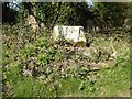
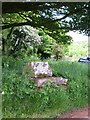
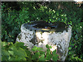
Source: Coflein, 'A cross-base of two steps, surmounted by a socket stone, remain of a wayside cross'.
You may be viewing yesterday's version of this page. To see the most up to date information please register for a free account.
")
Do not use the above information on other web sites or publications without permission of the contributor.
Nearby Images from Geograph Britain and Ireland:

©2024(licence)
©2017(licence)
©2010(licence)
©2009(licence)

©2015(licence)
The above images may not be of the site on this page, they are loaded from Geograph.
Please Submit an Image of this site or go out and take one for us!
Click here to see more info for this site
Nearby sites
Key: Red: member's photo, Blue: 3rd party photo, Yellow: other image, Green: no photo - please go there and take one, Grey: site destroyed
Download sites to:
KML (Google Earth)
GPX (GPS waypoints)
CSV (Garmin/Navman)
CSV (Excel)
To unlock full downloads you need to sign up as a Contributory Member. Otherwise downloads are limited to 50 sites.
Turn off the page maps and other distractions
Nearby sites listing. In the following links * = Image available
685m WSW 248° Gaer (Trellech)* Hillfort (SO493038)
1.1km N 359° Harolds Stones* Stone Row / Alignment (SO49930514)
1.1km NNE 18° Virtuous Well* Holy Well or Sacred Spring (SO50300509)
1.4km N 4° Trelleck Churchyard Cross* Ancient Cross (SO5004605466)
2.7km S 180° Trellech United Standing Stone (Menhir) (SO499013)
3.7km SSE 147° Tintern 2* Round Barrow(s) (SO5197000913)
3.7km SE 145° Tintern 1* Round Barrow(s) (SO5207200980)
3.8km SE 145° Lower Halewood Round Barrow(s) (SO521009)
5.3km ESE 120° Cup Stone on Mill Hill* Rock Art (SO545014)
5.6km SE 132° Offa's Dyke near Brockweir* Misc. Earthwork (SO541003)
5.8km E 85° St Bride's Well* Holy Well or Sacred Spring (SO5574404515)
5.8km NNE 16° Peny Garn Cross Base* Ancient Cross (SO5158909643)
5.8km SSE 149° Blackfield Wood* Hillfort (ST529990)
6.0km E 87° The Ancient Barrow Well, St. Briavel's* Holy Well or Sacred Spring (SO5593004337)
6.0km E 85° St Briavels Cross Slab* Early Christian Sculptured Stone (SO5592504540)
6.3km SSE 163° Gaer Hill Camp* Hillfort (ST517980)
6.4km N 353° Mitchel Troy Churchyard Cross* Ancient Cross (SO4923010370)
6.6km SW 229° Cwrt-Y-Gaer Misc. Earthwork (ST449998)
6.6km S 187° Chepstow Park Wood Cairn Cairn (ST491975)
6.8km W 263° Great House Camp* Hillfort (SO432033)
6.9km ENE 69° Stowe Enclosure* Misc. Earthwork (SO56430643)
6.9km NNW 348° Wonastow Churchyard Cross* Ancient Cross (SO4855410814)
7.0km NNE 18° Penallt Churchyard Cross* Ancient Cross (SO5220010720)
7.1km ESE 122° East Wood Ring Cairn* Ring Cairn (SO5594600157)
7.6km NW 326° Dingestow Churchyard Cross* Ancient Cross (SO4571010390)
View more nearby sites and additional images


 We would like to know more about this location. Please feel free to add a brief description and any relevant information in your own language.
 Wir möchten mehr über diese Stätte erfahren. Bitte zögern Sie nicht, eine kurze Beschreibung und relevante Informationen in Deutsch hinzuzufügen.
 Nous aimerions en savoir encore un peu sur les lieux. S'il vous plaît n'hesitez pas à ajouter une courte description et tous les renseignements pertinents dans votre propre langue.
 Quisieramos informarnos un poco más de las lugares. No dude en añadir una breve descripción y otros datos relevantes en su propio idioma.