 with our Megalithic Portal iPhone app")


<< Our Photo Pages >> Garn Lwyd - Ring Cairn in Wales in Mid Glamorgan
Submitted by sem on Sunday, 04 June 2017 Page Views: 2984
Neolithic and Bronze AgeSite Name: Garn LwydCountry: Wales
NOTE: This site is 1.004 km away from the location you searched for.
County: Mid Glamorgan Type: Ring Cairn
Nearest Town: Bridgend Nearest Village: Ogmore Vale
Map Ref: SS9199090146
Latitude: 51.599766N Longitude: 3.560855W
Condition:
| 5 | Perfect |
| 4 | Almost Perfect |
| 3 | Reasonable but with some damage |
| 2 | Ruined but still recognisable as an ancient site |
| 1 | Pretty much destroyed, possibly visible as crop marks |
| 0 | No data. |
| -1 | Completely destroyed |
| 5 | Superb |
| 4 | Good |
| 3 | Ordinary |
| 2 | Not Good |
| 1 | Awful |
| 0 | No data. |
| 5 | Can be driven to, probably with disabled access |
| 4 | Short walk on a footpath |
| 3 | Requiring a bit more of a walk |
| 2 | A long walk |
| 1 | In the middle of nowhere, a nightmare to find |
| 0 | No data. |
| 5 | co-ordinates taken by GPS or official recorded co-ordinates |
| 4 | co-ordinates scaled from a detailed map |
| 3 | co-ordinates scaled from a bad map |
| 2 | co-ordinates of the nearest village |
| 1 | co-ordinates of the nearest town |
| 0 | no data |
Internal Links:
External Links:
I have visited· I would like to visit
sem has visited here
")
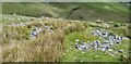
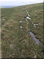
Described on Coflein (NPRN 307669) as a possible Ring Cairn "in an uncharacteristic on a steep NE-facing slope."
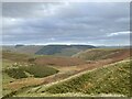
From it there is a good view of the valley floor, something quite rare in this locality.
You may be viewing yesterday's version of this page. To see the most up to date information please register for a free account.
")
")
")
")
Do not use the above information on other web sites or publications without permission of the contributor.
Nearby Images from Geograph Britain and Ireland:
©2017(licence)
©2017(licence)
©2020(licence)
©2012(licence)
©2017(licence)
The above images may not be of the site on this page, they are loaded from Geograph.
Please Submit an Image of this site or go out and take one for us!
Click here to see more info for this site
Nearby sites
Key: Red: member's photo, Blue: 3rd party photo, Yellow: other image, Green: no photo - please go there and take one, Grey: site destroyed
Download sites to:
KML (Google Earth)
GPX (GPS waypoints)
CSV (Garmin/Navman)
CSV (Excel)
To unlock full downloads you need to sign up as a Contributory Member. Otherwise downloads are limited to 50 sites.
Turn off the page maps and other distractions
Nearby sites listing. In the following links * = Image available
2.7km E 91° Bryn-Y-Cae Cairn (SS94689002)
2.8km NNE 27° Burry Holms Fort Hillfort (SS933926)
3.2km N 359° Carn-Y-Hyrddod* Cairn (SS91999339)
3.4km S 176° Bryn y Wrach Round Barrow(s) (SS9218086729)
3.4km S 176° Bryn-Y-Wrach* Round Cairn (SS92188672)
4.0km ENE 66° Garn Fach Cairn (SS957917)
4.1km N 349° The Werfa Round Barrow(s) (SS913942)
4.1km NE 50° Garn Fawr (Ogmore Valley)* Cairn (SS95229271)
4.2km E 96° Mynydd Maendy Cairn (SS96168964)
4.7km NE 35° Craig y Geifr Cairn (SS94809395)
4.8km NNE 24° Bwlch y Clawdd* Modern Stone Circle etc (SS94039450)
5.3km N 359° Crugyrafan* Round Barrow(s) (SS920954)
5.4km NNE 30° Bwlch y Clawdd Cairn Cairn (SS948948)
5.5km SE 141° Mynnydd y Gaer* Cairn (SS95378584)
5.7km E 89° Mynydd Maes-Teg Cairn (SS97699014)
6.8km NE 52° Mynydd Y Gelli* Stone Circle (SS975942)
6.8km E 80° Carn-Y-Celyn* Cairn (SS98779114)
6.9km S 178° Cefn Hirgoed Misc. Earthwork (SS92068324)
7.1km NNE 32° Treorchy Gorsedd Circle* Modern Stone Circle etc (SS9585596145)
7.1km N 351° Pebyll Cairn* Ring Cairn (SS9108097239)
7.4km NNW 348° Mynydd Blaengwynfi Cairn* Cairn (SS9060297368)
7.5km SE 133° Mynydd y Gaer* Hillfort (SS97358495)
7.7km S 173° Pant-Y-Pyllau Ancient Village or Settlement (SS92728243)
8.0km N 350° Bachgen Carreg* Cairn (SS9081298111)
8.2km S 174° Coity* Chambered Cairn (SS92698193)
View more nearby sites and additional images


 We would like to know more about this location. Please feel free to add a brief description and any relevant information in your own language.
 Wir möchten mehr über diese Stätte erfahren. Bitte zögern Sie nicht, eine kurze Beschreibung und relevante Informationen in Deutsch hinzuzufügen.
 Nous aimerions en savoir encore un peu sur les lieux. S'il vous plaît n'hesitez pas à ajouter une courte description et tous les renseignements pertinents dans votre propre langue.
 Quisieramos informarnos un poco más de las lugares. No dude en añadir una breve descripción y otros datos relevantes en su propio idioma.