


<< Text Pages >> The High Stone of Snaresbrook - Marker Stone in England in Greater London
Submitted by Andy B on Tuesday, 08 July 2025 Page Views: 4091
Multi-periodSite Name: The High Stone of Snaresbrook Alternative Name: The Leyton StoneCountry: England
NOTE: This site is 1.922 km away from the location you searched for.
County: Greater London Type: Marker Stone
Nearest Town: Leytonstone
Map Ref: TQ3991388103
Latitude: 51.574438N Longitude: 0.017599E
Condition:
| 5 | Perfect |
| 4 | Almost Perfect |
| 3 | Reasonable but with some damage |
| 2 | Ruined but still recognisable as an ancient site |
| 1 | Pretty much destroyed, possibly visible as crop marks |
| 0 | No data. |
| -1 | Completely destroyed |
| 5 | Superb |
| 4 | Good |
| 3 | Ordinary |
| 2 | Not Good |
| 1 | Awful |
| 0 | No data. |
| 5 | Can be driven to, probably with disabled access |
| 4 | Short walk on a footpath |
| 3 | Requiring a bit more of a walk |
| 2 | A long walk |
| 1 | In the middle of nowhere, a nightmare to find |
| 0 | No data. |
| 5 | co-ordinates taken by GPS or official recorded co-ordinates |
| 4 | co-ordinates scaled from a detailed map |
| 3 | co-ordinates scaled from a bad map |
| 2 | co-ordinates of the nearest village |
| 1 | co-ordinates of the nearest town |
| 0 | no data |
Internal Links:
External Links:
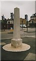
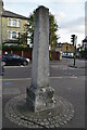
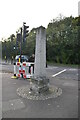
At the junction of Hollybush Hill and New Wanstead. A stone like this has been shown here on maps since at least 1774, but it was thought to be much older and may date back to the Roman period. It is probably the stone in the name of Leytonstone.
In 1370 the village was referred to as Leyton-atte-Stone. The upright stone has been replaced but the base is very old. In recent times the upper stone has served as a tall signpost or milestone and the now shows which road to follow when leaving London:
To Epping | To Ongar
XI Miles | XVI Miles
Through | Through
Woodford | Woodford Bridge
Loughton | Chigwell, Abridge
It is truer to say that this is what would be there if the black colouring had not dropped out from the letters.
Source: exploringeastlondon.co.uk/eel/Leytonstone/Leytonstone.htm
You may be viewing yesterday's version of this page. To see the most up to date information please register for a free account.
Do not use the above information on other web sites or publications without permission of the contributor.
Nearby Images from Geograph Britain and Ireland:
©2019(licence)
©2022(licence)
©2022(licence)
©2022(licence)
©2022(licence)
The above images may not be of the site on this page, they are loaded from Geograph.
Please Submit an Image of this site or go out and take one for us!
Click here to see more info for this site
Nearby sites
Key: Red: member's photo, Blue: 3rd party photo, Yellow: other image, Green: no photo - please go there and take one, Grey: site destroyed
Download sites to:
KML (Google Earth)
GPX (GPS waypoints)
CSV (Garmin/Navman)
CSV (Excel)
To unlock full downloads you need to sign up as a Contributory Member. Otherwise downloads are limited to 50 sites.
Turn off the page maps and other distractions
Nearby sites listing. In the following links * = Image available
838m N 350° The Birch Well Holy Well or Sacred Spring (TQ3974588924)
2.9km NNW 347° Gipsy Smith* Modern Stone Circle etc (TQ392909)
5.8km ESE 121° Holy well (Barking) Holy Well or Sacred Spring (TQ450853)
6.3km WNW 284° St. Eloy's Well* Holy Well or Sacred Spring (TQ338895)
7.0km NNW 348° Pole Hill* Modern Stone Circle etc (TQ383949)
7.3km E 80° St Chad's Well (Chadwell Heath)* Holy Well or Sacred Spring (TQ4706389580)
8.0km W 268° Finsbury Park earthworks* Artificial Mound (TQ3186087537)
8.2km ESE 102° Valence House* Museum (TQ4803386569)
9.6km NNE 13° Loughton Camp* Hillfort (TQ418975)
9.8km SW 222° St Olave's Well* Holy Well or Sacred Spring (TQ335807)
9.8km SW 226° Roman Basilica at 85 Gracechurch Street* Ancient Palace (TQ3303481051)
9.9km SW 223° All Hallows by the Tower* Museum (TQ3337380695)
10.2km SW 227° London Stone* Marker Stone (TQ3267680903)
10.2km SW 231° Museum of London* Museum (TQ321815)
10.2km SW 228° Mithras Temple (London)* Ancient Temple (TQ3252181031)
10.3km SW 234° Cow Cross (Finsbury) Ancient Cross (TQ31788181)
10.3km SW 230° Broken Cross (Westminster) Ancient Cross (TQ322812)
10.3km WSW 236° Clerk's Well (Farringdon Lane) Holy Well or Sacred Spring (TQ3145282134)
10.4km WSW 237° Skinner's Well (Finsbury) Holy Well or Sacred Spring (TQ313822)
10.4km N 8° High Beach* Artificial Mound (TQ410985)
10.8km NW 315° Bush Hill Hillfort (TQ321956)
10.8km WNW 284° St. Dunstan's Well Holy Well or Sacred Spring (TQ293905)
10.9km SW 232° Bridewell (Fleet Street) Holy Well or Sacred Spring (TQ315812)
11.0km WSW 241° Coram* Modern Stone Circle etc (TQ3044582417)
11.0km S 187° Greenwich Park Barrows* Barrow Cemetery (TQ3883677128)
View more nearby sites and additional images


 We would like to know more about this location. Please feel free to add a brief description and any relevant information in your own language.
 Wir möchten mehr über diese Stätte erfahren. Bitte zögern Sie nicht, eine kurze Beschreibung und relevante Informationen in Deutsch hinzuzufügen.
 Nous aimerions en savoir encore un peu sur les lieux. S'il vous plaît n'hesitez pas à ajouter une courte description et tous les renseignements pertinents dans votre propre langue.
 Quisieramos informarnos un poco más de las lugares. No dude en añadir una breve descripción y otros datos relevantes en su propio idioma.