


<< Our Photo Pages >> Gorsedd Stone Circle (Tredegar House) - Modern Stone Circle etc in Wales in Gwynedd
Submitted by DavidHoyle on Sunday, 22 December 2024 Page Views: 1238
Modern SitesSite Name: Gorsedd Stone Circle (Tredegar House)Country: Wales
NOTE: This site is 1.776 km away from the location you searched for.
County: Gwynedd Type: Modern Stone Circle etc
Nearest Town: Newport
Map Ref: ST2882885376
Latitude: 51.562752N Longitude: 3.028132W
Condition:
| 5 | Perfect |
| 4 | Almost Perfect |
| 3 | Reasonable but with some damage |
| 2 | Ruined but still recognisable as an ancient site |
| 1 | Pretty much destroyed, possibly visible as crop marks |
| 0 | No data. |
| -1 | Completely destroyed |
| 5 | Superb |
| 4 | Good |
| 3 | Ordinary |
| 2 | Not Good |
| 1 | Awful |
| 0 | No data. |
| 5 | Can be driven to, probably with disabled access |
| 4 | Short walk on a footpath |
| 3 | Requiring a bit more of a walk |
| 2 | A long walk |
| 1 | In the middle of nowhere, a nightmare to find |
| 0 | No data. |
| 5 | co-ordinates taken by GPS or official recorded co-ordinates |
| 4 | co-ordinates scaled from a detailed map |
| 3 | co-ordinates scaled from a bad map |
| 2 | co-ordinates of the nearest village |
| 1 | co-ordinates of the nearest town |
| 0 | no data |
Internal Links:
External Links:
I have visited· I would like to visit
hevveh has visited here
 (PID:283146)")
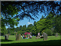
Gorsedd Stone Circles are constructed for the National Eisteddfod and form a key part of ceremonies held during the festival. The Stone Circle in the parkland was erected in 1987 to proclaim that the Eisteddfod was to be held at Tredegar House the following year. The 12 stones which form the circle represent the 12 old counties of Wales. The tallest stone is 1.5m high, and the central plinth (the Logan Stone) is used by the Archdruid to proclaim the festival. The circle is then used throughout the week for ceremonial dances and the inauguration of new members of the Druid Circle.
You may be viewing yesterday's version of this page. To see the most up to date information please register for a free account.
Do not use the above information on other web sites or publications without permission of the contributor.
Nearby Images from Geograph Britain and Ireland:
![ST2885 : St. Mellons Show 2010 [2] by Robin Drayton](https://s3.geograph.org.uk/geophotos/02/00/52/2005231_230fbbfc_120x120.jpg)
©2010(licence)
![ST2885 : St. Mellons Show 2010 [1] by Robin Drayton](https://s1.geograph.org.uk/geophotos/02/00/52/2005225_b4599524_120x120.jpg)
©2010(licence)

©2017(licence)
©2018(licence)
![ST2885 : St. Mellons Show 2010 [5] by Robin Drayton](https://s3.geograph.org.uk/geophotos/02/00/54/2005463_21745428_120x120.jpg)
©2010(licence)
The above images may not be of the site on this page, they are loaded from Geograph.
Please Submit an Image of this site or go out and take one for us!
Click here to see more info for this site
Nearby sites
Key: Red: member's photo, Blue: 3rd party photo, Yellow: other image, Green: no photo - please go there and take one, Grey: site destroyed
Download sites to:
KML (Google Earth)
GPX (GPS waypoints)
CSV (Garmin/Navman)
CSV (Excel)
To unlock full downloads you need to sign up as a Contributory Member. Otherwise downloads are limited to 50 sites.
Turn off the page maps and other distractions
Nearby sites listing. In the following links * = Image available
1.2km WSW 254° Gwern y Cleppa* Chambered Tomb (ST27648505)
1.4km N 6° Tredegar Hillfort* Hillfort (ST290868)
1.7km WNW 295° Coed Ffynnon-Oer Hillfort (ST273861)
2.6km NW 317° Bassaleg* Standing Stones (ST2709487274)
3.0km W 260° The Mount* Hillfort (ST259849)
3.1km WSW 258° Graig (Monmouthshire) Cairn (ST258848)
3.2km WNW 286° Croes-Carn-Einion Hillfort (ST258863)
3.3km WNW 299° Rhiwderin (Newport) Rock Art (ST260870)
3.4km NW 313° Rhiwderin Camp Hillfort (ST264877)
3.5km NE 43° Newport Museum and Art Gallery* Museum (ST31278791)
4.8km SE 124° Mesolithic Human Footprints at Uskmouth* Natural Stone / Erratic / Other Natural Feature (ST32808260)
5.1km WSW 247° Druidstone (Michaelstone)* Standing Stone (Menhir) (ST24138342)
5.3km NE 52° Maindee Camp Ancient Village or Settlement (ST3304588604)
5.3km NE 52° Maindy Hill Camp Misc. Earthwork (ST3304588604)
6.0km NW 305° Twyn Pant-Teg Round Barrow(s) (ST240889)
6.0km NW 304° Twyn Pant-Teg Cairn (ST239888)
6.1km NNW 328° Risca Round Cairn (ST257906)
6.4km NE 53° St Julian's Wood Hillfort (ST340892)
6.6km NNW 329° Rogerstone 1 Round Barrow(s) (ST255911)
6.6km NW 324° Rogerstone 2 Round Barrow(s) (ST250908)
6.9km NNE 30° Lodge Wood* Hillfort (ST323913)
7.0km NE 44° Caerleon Roman Amphitheatre* Ancient Temple (ST33839035)
7.3km NE 44° Caerleon Roman Fortress and Baths* Ancient Village or Settlement (ST33959058)
7.5km ESE 104° Goldcliff Earthwork Misc. Earthwork (ST361835)
7.6km NNW 329° Henllys Complex Barrow Cemetery (ST2592)
View more nearby sites and additional images


 We would like to know more about this location. Please feel free to add a brief description and any relevant information in your own language.
 Wir möchten mehr über diese Stätte erfahren. Bitte zögern Sie nicht, eine kurze Beschreibung und relevante Informationen in Deutsch hinzuzufügen.
 Nous aimerions en savoir encore un peu sur les lieux. S'il vous plaît n'hesitez pas à ajouter une courte description et tous les renseignements pertinents dans votre propre langue.
 Quisieramos informarnos un poco más de las lugares. No dude en añadir una breve descripción y otros datos relevantes en su propio idioma.