


<< Our Photo Pages >> St. Frideswide's Well - Holy Well or Sacred Spring in England in Berkshire
Submitted by Junreisha on Wednesday, 30 December 2020 Page Views: 3075
Springs and Holy WellsSite Name: St. Frideswide's WellCountry: England County: Berkshire Type: Holy Well or Sacred Spring
Nearest Village: Frilsham
Map Ref: SU54997326
Latitude: 51.455657N Longitude: 1.209958W
Condition:
| 5 | Perfect |
| 4 | Almost Perfect |
| 3 | Reasonable but with some damage |
| 2 | Ruined but still recognisable as an ancient site |
| 1 | Pretty much destroyed, possibly visible as crop marks |
| 0 | No data. |
| -1 | Completely destroyed |
| 5 | Superb |
| 4 | Good |
| 3 | Ordinary |
| 2 | Not Good |
| 1 | Awful |
| 0 | No data. |
| 5 | Can be driven to, probably with disabled access |
| 4 | Short walk on a footpath |
| 3 | Requiring a bit more of a walk |
| 2 | A long walk |
| 1 | In the middle of nowhere, a nightmare to find |
| 0 | No data. |
| 5 | co-ordinates taken by GPS or official recorded co-ordinates |
| 4 | co-ordinates scaled from a detailed map |
| 3 | co-ordinates scaled from a bad map |
| 2 | co-ordinates of the nearest village |
| 1 | co-ordinates of the nearest town |
| 0 | no data |
Internal Links:
External Links:
I have visited· I would like to visit
irodori-00 would like to visit
")
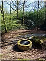
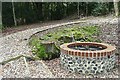
One of the local legends tells us that St Frideswide, fleeing from the attentions of a Mercian prince in the late 7th century came to Frilsham and concealed herself as a swineherd.
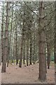
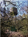
However, the reputed site of the well where she is said to have healed local people is at the top of the hill, on Frilsham common.
St. Frideswide may have hidden there for some time, sustained by a nearby well, which is preserved to this day in the wooded common.
It is even suggested that her pigsty is on the site of the current church near the River Pang and Frilsham Manor.
You may be viewing yesterday's version of this page. To see the most up to date information please register for a free account.
")
")
")
Do not use the above information on other web sites or publications without permission of the contributor.
Nearby Images from Geograph Britain and Ireland:
©2013(licence)
©2008(licence)
©2008(licence)
©2013(licence)
©2008(licence)
The above images may not be of the site on this page, they are loaded from Geograph.
Please Submit an Image of this site or go out and take one for us!
Click here to see more info for this site
Nearby sites
Key: Red: member's photo, Blue: 3rd party photo, Yellow: other image, Green: no photo - please go there and take one, Grey: site destroyed
Download sites to:
KML (Google Earth)
GPX (GPS waypoints)
CSV (Garmin/Navman)
CSV (Excel)
To unlock full downloads you need to sign up as a Contributory Member. Otherwise downloads are limited to 50 sites.
Turn off the page maps and other distractions
Nearby sites listing. In the following links * = Image available
3.9km WSW 256° Grimsbury Castle* Hillfort (SU512723)
4.4km SW 215° Ramsbury Corner* Hillfort (SU525696)
5.2km E 98° St. Andrew's Well* Holy Well or Sacred Spring (SU602726)
5.3km N 356° Grim's Ditch (Berkshire) Ancient Village or Settlement (SU546785)
5.5km NNW 328° Perborough Castle* Hillfort (SU520779)
5.8km SSW 208° Dunston Park Ancient Village or Settlement (SU523681)
5.9km WNW 289° Oareborough Hill* Hillfort (SU49407515)
7.8km ESE 120° Ufton Nervet Cursus Cursus (SU618695)
7.9km ESE 106° Englefield Cursus (SU626712)
8.1km ESE 121° Ufton Nervet Cursus Cursus (SU620691)
8.1km ESE 112° Englefield Cursus (SU626703)
8.2km W 266° Bussock Camp* Hillfort (SU468726)
8.4km NE 41° Goring Enclosure Causewayed Enclosure (SU604797)
8.6km NE 41° Goring Cursus Cursus (SU606798)
9.0km N 354° Lowbury Hill Camp Ancient Temple (SU5400082250)
9.9km SW 232° West Berkshire Museum Museum (SU472671)
10.0km NNE 18° Lingley Knob Round Barrow(s) (SU57978276)
10.0km NNE 18° Lingley Knoll Misc. Earthwork (SU58048274)
10.5km NNW 344° The Warrior Barrows* Round Barrow(s) (SU520833)
10.5km ENE 61° Bozedown Camp* Hillfort (SU6419578403)
10.6km SE 133° Raven Hill* Promontory Fort / Cliff Castle (SU62876615)
10.6km ESE 108° Burghfield Cursus Cursus (SU65137000)
10.6km W 281° Leckhampstead Bowl Barrow Round Barrow(s) (SU44507518)
10.7km NNW 337° Fox Barrow* Round Barrow(s) (SU50718308)
10.8km SE 128° Ufton Nervet Bell Barrow* Round Barrow(s) (SU6356266625)
View more nearby sites and additional images


 We would like to know more about this location. Please feel free to add a brief description and any relevant information in your own language.
 Wir möchten mehr über diese Stätte erfahren. Bitte zögern Sie nicht, eine kurze Beschreibung und relevante Informationen in Deutsch hinzuzufügen.
 Nous aimerions en savoir encore un peu sur les lieux. S'il vous plaît n'hesitez pas à ajouter une courte description et tous les renseignements pertinents dans votre propre langue.
 Quisieramos informarnos un poco más de las lugares. No dude en añadir una breve descripción y otros datos relevantes en su propio idioma.