<< Our Photo Pages >> Stonehenge miniature - Modern Stone Circle etc in Germany in Saxony
Submitted by Klingon on Sunday, 10 September 2006 Page Views: 9274
Modern SitesSite Name: Stonehenge miniatureCountry: Germany
NOTE: This site is 22.076 km away from the location you searched for.
Land: Saxony Type: Modern Stone Circle etc
Nearest Town: Lichtenstein
Latitude: 50.762408N Longitude: 12.641704E
Condition:
| 5 | Perfect |
| 4 | Almost Perfect |
| 3 | Reasonable but with some damage |
| 2 | Ruined but still recognisable as an ancient site |
| 1 | Pretty much destroyed, possibly visible as crop marks |
| 0 | No data. |
| -1 | Completely destroyed |
| 5 | Superb |
| 4 | Good |
| 3 | Ordinary |
| 2 | Not Good |
| 1 | Awful |
| 0 | No data. |
| 5 | Can be driven to, probably with disabled access |
| 4 | Short walk on a footpath |
| 3 | Requiring a bit more of a walk |
| 2 | A long walk |
| 1 | In the middle of nowhere, a nightmare to find |
| 0 | No data. |
| 5 | co-ordinates taken by GPS or official recorded co-ordinates |
| 4 | co-ordinates scaled from a detailed map |
| 3 | co-ordinates scaled from a bad map |
| 2 | co-ordinates of the nearest village |
| 1 | co-ordinates of the nearest town |
| 0 | no data |
Internal Links:
External Links:
I have visited· I would like to visit
Klingon has visited here
")
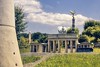
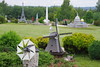
The Miniworld landscape park shows about 160 reproductions of famous buildings from all over the world like the Tower of London, the Eiffel tower, the Taj Mahal, many castles and an airport.
Also a miniature of the famous Stonehenge stone circle is displayed. More information about this copy here.
You may be viewing yesterday's version of this page. To see the most up to date information please register for a free account.
Do not use the above information on other web sites or publications without permission of the contributor.
Nearby Images from Flickr

The above images may not be of the site on this page, but were taken nearby. They are loaded from Flickr so please click on them for image credits.
Click here to see more info for this site
Nearby sites
Click here to view sites on an interactive map of the areaKey: Red: member's photo, Blue: 3rd party photo, Yellow: other image, Green: no photo - please go there and take one, Grey: site destroyed
Download sites to:
KML (Google Earth)
GPX (GPS waypoints)
CSV (Garmin/Navman)
CSV (Excel)
To unlock full downloads you need to sign up as a Contributory Member. Otherwise downloads are limited to 50 sites.
Turn off the page maps and other distractions
Nearby sites listing. In the following links * = Image available
23.0km SSW 209° Taufstein von Pechtelsgrün Rock Art
24.0km ESE 122° Greifensteine Natural Stone / Erratic / Other Natural Feature
37.3km W 273° Der Dachshügel Ancient Village or Settlement
37.4km NW 304° Pölzig* Barrow Cemetery
38.4km WNW 287° Collis Round Barrow(s)
39.9km W 278° Zedlitz Round Barrow(s)
40.2km WNW 282° Zoitzberg Causewayed Enclosure
40.6km WNW 297° Wüster Hain Dorna Artificial Mound
40.7km WNW 299° Söllmnitz-Cretzschwitz (1) Artificial Mound
40.8km WNW 300° Söllmnitz-Cretzschwitz (2) Barrow Cemetery
41.9km W 279° Vogelherd Round Barrow(s)
42.3km W 266° Steinsdorf Round Barrow(s)
42.4km WNW 285° Debschwitz Artificial Mound
42.5km WNW 287° Hainberg Artificial Mound
42.6km WNW 287° Untermhaus (2) Artificial Mound
42.7km WNW 288° Untermhaus (1) Causewayed Enclosure
43.1km WNW 294° Roschütz Artificial Mound
45.3km NNE 15° Erlln Round Barrow(s)
45.7km NNE 17° Maaschwitz Barrow Cemetery
45.9km NNE 16° Thümmlitzwald Hügelgräber Barrow Cemetery
46.3km WNW 291° Rubitz Barrow Cemetery
46.8km NNE 16° Thümmlitzwald Monolith I* Standing Stone (Menhir)
47.0km NNE 17° Lochstein Thümmlitzwald* Holed Stone
47.8km NNE 17° Thümmlitzwald Mühlstein* Natural Stone / Erratic / Other Natural Feature
47.8km NNE 17° Thümmlitzwald Menhir* Standing Stone (Menhir)
View more nearby sites and additional images


 We would like to know more about this location. Please feel free to add a brief description and any relevant information in your own language.
 Wir möchten mehr über diese Stätte erfahren. Bitte zögern Sie nicht, eine kurze Beschreibung und relevante Informationen in Deutsch hinzuzufügen.
 Nous aimerions en savoir encore un peu sur les lieux. S'il vous plaît n'hesitez pas à ajouter une courte description et tous les renseignements pertinents dans votre propre langue.
 Quisieramos informarnos un poco más de las lugares. No dude en añadir una breve descripción y otros datos relevantes en su propio idioma.