


<< Other Photo Pages >> Ranscombe Camp - Ancient Village or Settlement in England in East Sussex
Submitted by coldrum on Wednesday, 07 May 2008 Page Views: 6133
Multi-periodSite Name: Ranscombe Camp Alternative Name: Ranscombe HillCountry: England County: East Sussex Type: Ancient Village or Settlement
Nearest Town: Lewes
Map Ref: TQ438091
Latitude: 50.863532N Longitude: 0.041991E
Condition:
| 5 | Perfect |
| 4 | Almost Perfect |
| 3 | Reasonable but with some damage |
| 2 | Ruined but still recognisable as an ancient site |
| 1 | Pretty much destroyed, possibly visible as crop marks |
| 0 | No data. |
| -1 | Completely destroyed |
| 5 | Superb |
| 4 | Good |
| 3 | Ordinary |
| 2 | Not Good |
| 1 | Awful |
| 0 | No data. |
| 5 | Can be driven to, probably with disabled access |
| 4 | Short walk on a footpath |
| 3 | Requiring a bit more of a walk |
| 2 | A long walk |
| 1 | In the middle of nowhere, a nightmare to find |
| 0 | No data. |
| 5 | co-ordinates taken by GPS or official recorded co-ordinates |
| 4 | co-ordinates scaled from a detailed map |
| 3 | co-ordinates scaled from a bad map |
| 2 | co-ordinates of the nearest village |
| 1 | co-ordinates of the nearest town |
| 0 | no data |
Internal Links:
External Links:
")
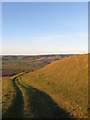
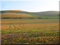
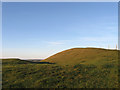
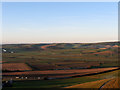
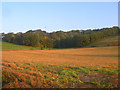
One of a pair of large ramparts running along the eastern edge of a spur to the west of Mount Caburn. They date back to the Bronze Age and in fact predate the works on Mount Caburn. The possibility is they were works to delineate a boundary though the spur was settled by the Romano-British in the 2nd century and may have been turned into protective earthworks then though there are no longer any signs of similar works on the side facing Lewes. The farm track follows the curve of the earthworks around the southern side too.
Text by Simon Carey
You may be viewing yesterday's version of this page. To see the most up to date information please register for a free account.
")
")
")
Do not use the above information on other web sites or publications without permission of the contributor.
Nearby Images from Geograph Britain and Ireland:
©2011(licence)
©2008(licence)
©2011(licence)
©2011(licence)
©2008(licence)
The above images may not be of the site on this page, they are loaded from Geograph.
Please Submit an Image of this site or go out and take one for us!
Click here to see more info for this site
Nearby sites
Key: Red: member's photo, Blue: 3rd party photo, Yellow: other image, Green: no photo - please go there and take one, Grey: site destroyed
Download sites to:
KML (Google Earth)
GPX (GPS waypoints)
CSV (Garmin/Navman)
CSV (Excel)
To unlock full downloads you need to sign up as a Contributory Member. Otherwise downloads are limited to 50 sites.
Turn off the page maps and other distractions
Nearby sites listing. In the following links * = Image available
707m N 10° Oxteddle Bottom Field System. Misc. Earthwork (TQ439098)
726m ESE 108° The Caburn* Hillfort (TQ445089)
1.0km N 356° The Bible Earthwork Misc. Earthwork (TQ437101)
1.4km NNE 26° Oxteddle Bottom Barrow Cemetery (TQ444104)
1.8km NNW 345° Cliffe Hill Tumuli Round Barrow(s) (TQ433108)
2.0km NNW 342° Malling Hill Long Barrow* Long Barrow (TQ4311810996)
2.2km NNW 332° Malling Hill Field System Misc. Earthwork (TQ427110)
3.9km SSE 168° Itford Hill Ancient Village or Settlement (TQ447053)
4.1km S 175° Pook's Dyke Misc. Earthwork (TQ44270507)
4.4km WSW 257° The Gurdy Stone* Modern Stone Circle etc (TQ3948408002)
4.7km NW 305° Offham Hill* Causewayed Enclosure (TQ399117)
4.7km SE 132° Firle Plantation Tumuli* Barrow Cemetery (TQ474060)
4.8km ESE 105° Adder Wells Cross Early Christian Sculptured Stone (TQ485080)
5.3km N 356° Bridge Farm Romano British settlement site* Ancient Village or Settlement (TQ433144)
5.4km SE 140° Lord’s Burghs Tumuli Barrow Cemetery (TQ474051)
5.6km SE 127° Firle Beacon Long Barrow* Long Barrow (TQ484058)
5.9km SE 126° Firle East Barrow* Round Barrow(s) (TQ4867305813)
5.9km SE 126° Firle Beacon Tumuli* Barrow Cemetery (TQ487058)
6.1km SE 125° Trilton Tumuli* Barrow Cemetery (TQ4885205728)
6.4km SE 127° Loose Plantation crossways group* Barrow Cemetery (TQ4903405436)
6.6km SE 128° Loose Plantation Tumuli* Barrow Cemetery (TQ491052)
6.7km SE 127° Bopeep West tumulus* Round Barrow(s) (TQ4926905232)
6.9km SE 135° Bostal Bottom Tumuli Barrow Cemetery (TQ488043)
7.2km SSW 212° Telscombe Cross Dyke Misc. Earthwork (TQ402029)
7.2km SE 142° Five Lord's Burgh Tumulus Round Barrow(s) (TQ484035)
View more nearby sites and additional images


 We would like to know more about this location. Please feel free to add a brief description and any relevant information in your own language.
 Wir möchten mehr über diese Stätte erfahren. Bitte zögern Sie nicht, eine kurze Beschreibung und relevante Informationen in Deutsch hinzuzufügen.
 Nous aimerions en savoir encore un peu sur les lieux. S'il vous plaît n'hesitez pas à ajouter une courte description et tous les renseignements pertinents dans votre propre langue.
 Quisieramos informarnos un poco más de las lugares. No dude en añadir una breve descripción y otros datos relevantes en su propio idioma.