

<< Our Photo Pages >> Paignton Church Cross - Ancient Cross in England in Devon
Submitted by Bladup on Wednesday, 10 June 2026 Page Views: 60
Early MedievalSite Name: Paignton Church CrossCountry: England County: Devon Type: Ancient Cross
Map Ref: SX8865060800
Latitude: 50.436456N Longitude: 3.569298W
Condition:
| 5 | Perfect |
| 4 | Almost Perfect |
| 3 | Reasonable but with some damage |
| 2 | Ruined but still recognisable as an ancient site |
| 1 | Pretty much destroyed, possibly visible as crop marks |
| 0 | No data. |
| -1 | Completely destroyed |
| 5 | Superb |
| 4 | Good |
| 3 | Ordinary |
| 2 | Not Good |
| 1 | Awful |
| 0 | No data. |
| 5 | Can be driven to, probably with disabled access |
| 4 | Short walk on a footpath |
| 3 | Requiring a bit more of a walk |
| 2 | A long walk |
| 1 | In the middle of nowhere, a nightmare to find |
| 0 | No data. |
| 5 | co-ordinates taken by GPS or official recorded co-ordinates |
| 4 | co-ordinates scaled from a detailed map |
| 3 | co-ordinates scaled from a bad map |
| 2 | co-ordinates of the nearest village |
| 1 | co-ordinates of the nearest town |
| 0 | no data |
Internal Links:
External Links:
")
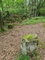
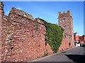
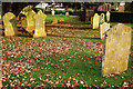
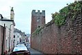
The Churchyard Cross to the south-east of the Parish Church of St John the Baptist has a medieval shaft and possibly base; The crosspiece is a late C19 or early C20 restoration. The cross is granite on a red breccia plinth. 3 breccia steps support a rectangular granite base with a moulded top. Slender, tapering, octagonal cross shaft, about 4m high, with decayed stops and a replaced granite crosspiece. There's also a foliated cross inside the church.
You may be viewing yesterday's version of this page. To see the most up to date information please register for a free account.
")
")
")
Do not use the above information on other web sites or publications without permission of the contributor.
Nearby Images from Geograph Britain and Ireland:
![SX8860 : Parish church [6] by Michael Dibb](https://s1.geograph.org.uk/geophotos/06/18/46/6184689_b894c1cd_120x120.jpg)
©2019(licence)
©2007(licence)
©2019(licence)
©2008(licence)
![SX8860 : Parish church [8] by Michael Dibb](https://s0.geograph.org.uk/geophotos/06/18/46/6184692_dd8a601e_120x120.jpg)
©2019(licence)
The above images may not be of the site on this page, they are loaded from Geograph.
Please Submit an Image of this site or go out and take one for us!
Click here to see more info for this site
Nearby sites
Key: Red: member's photo, Blue: 3rd party photo, Yellow: other image, Green: no photo - please go there and take one, Grey: site destroyed
Download sites to:
KML (Google Earth)
GPX (GPS waypoints)
CSV (Garmin/Navman)
CSV (Excel)
To unlock full downloads you need to sign up as a Contributory Member. Otherwise downloads are limited to 50 sites.
Turn off the page maps and other distractions
Nearby sites listing. In the following links * = Image available
3.5km SSE 168° Broadsands Chambered Tomb* Chambered Tomb (SX89315732)
3.6km NNE 33° Torre Abbey Cross Shaft* Ancient Cross (SX9070063790)
4.0km SW 214° Port Bridge Settlement* Ancient Village or Settlement (SX8636057550)
4.6km NE 51° Torquay Museum* Museum (SX9232863616)
5.9km NE 54° Kent's Cavern* Cave or Rock Shelter (SX93456418)
6.3km NE 34° Stonehenge at Babbacombe Model Village* Modern Stone Circle etc (SX923660)
6.4km NE 46° Walls Hill Field System* Ancient Village or Settlement (SX9338065140)
6.5km SE 128° Ash Hole Cavern* Cave or Rock Shelter (SX9370356680)
6.8km NW 324° Ipplepen Iron Age Settlement* Ancient Village or Settlement (SX848664)
7.2km S 177° Greenway Camp Hillfort (SX8885053630)
7.2km SE 125° Berry Head Promontory Fort* Promontory Fort / Cliff Castle (SX9450056500)
8.0km N 359° Doda Well* Holy Well or Sacred Spring (SX887688)
8.1km NNW 338° Ladywell (Abbotskerswell)* Holy Well or Sacred Spring (SX858684)
8.3km W 266° The Brutus Stone* Marker Stone (SX8035760411)
8.3km W 266° Totnes Museum* Museum (SX8030060419)
8.6km NNW 328° Dornafield Tumulus* Round Barrow(s) (SX842682)
8.7km W 266° Leech Wells* Holy Well or Sacred Spring (SX799603)
8.8km SSW 209° Capton Camp* Ancient Village or Settlement (SX842532)
9.1km N 357° Milber Down Camp* Hillfort (SX884699)
9.5km WNW 285° Staverton Enclosure Ancient Village or Settlement (SX795634)
9.6km NW 312° Tornewton Cave Cave or Rock Shelter (SX816674)
9.6km NW 311° Three Holes Cave Cave or Rock Shelter (SX815673)
9.7km NW 312° Brokern Cavern Cave or Rock Shelter (SX81596748)
10.3km WNW 283° Dartington North Wood Enclosures Ancient Village or Settlement (SX78636339)
10.4km NW 316° Denbury* Hillfort (SX816685)
View more nearby sites and additional images


 We would like to know more about this location. Please feel free to add a brief description and any relevant information in your own language.
 Wir möchten mehr über diese Stätte erfahren. Bitte zögern Sie nicht, eine kurze Beschreibung und relevante Informationen in Deutsch hinzuzufügen.
 Nous aimerions en savoir encore un peu sur les lieux. S'il vous plaît n'hesitez pas à ajouter une courte description et tous les renseignements pertinents dans votre propre langue.
 Quisieramos informarnos un poco más de las lugares. No dude en añadir una breve descripción y otros datos relevantes en su propio idioma.