<< Other Photo Pages Mistasiniy - Natural Stone / Erratic / Other Natural Feature in Canada
Submitted by TheDruid-3X3 on Friday, 27 June 2025 Page Views: 453
Natural PlacesSite Name: Mistasiniy Alternative Name: Buffalo Child StoneCountry: Canada
NOTE: This site is 216.512 km away from the location you searched for.
Type: Natural Stone / Erratic / Other Natural Feature
Nearest Town: Saskatoon Nearest Village: Mistusinne
Latitude: 51.057220N Longitude: 106.54097W
Condition:
| 5 | Perfect |
| 4 | Almost Perfect |
| 3 | Reasonable but with some damage |
| 2 | Ruined but still recognisable as an ancient site |
| 1 | Pretty much destroyed, possibly visible as crop marks |
| 0 | No data. |
| -1 | Completely destroyed |
| 5 | Superb |
| 4 | Good |
| 3 | Ordinary |
| 2 | Not Good |
| 1 | Awful |
| 0 | No data. |
| 5 | Can be driven to, probably with disabled access |
| 4 | Short walk on a footpath |
| 3 | Requiring a bit more of a walk |
| 2 | A long walk |
| 1 | In the middle of nowhere, a nightmare to find |
| 0 | No data. |
| 5 | co-ordinates taken by GPS or official recorded co-ordinates |
| 4 | co-ordinates scaled from a detailed map |
| 3 | co-ordinates scaled from a bad map |
| 2 | co-ordinates of the nearest village |
| 1 | co-ordinates of the nearest town |
| 0 | no data |
Internal Links:
External Links:

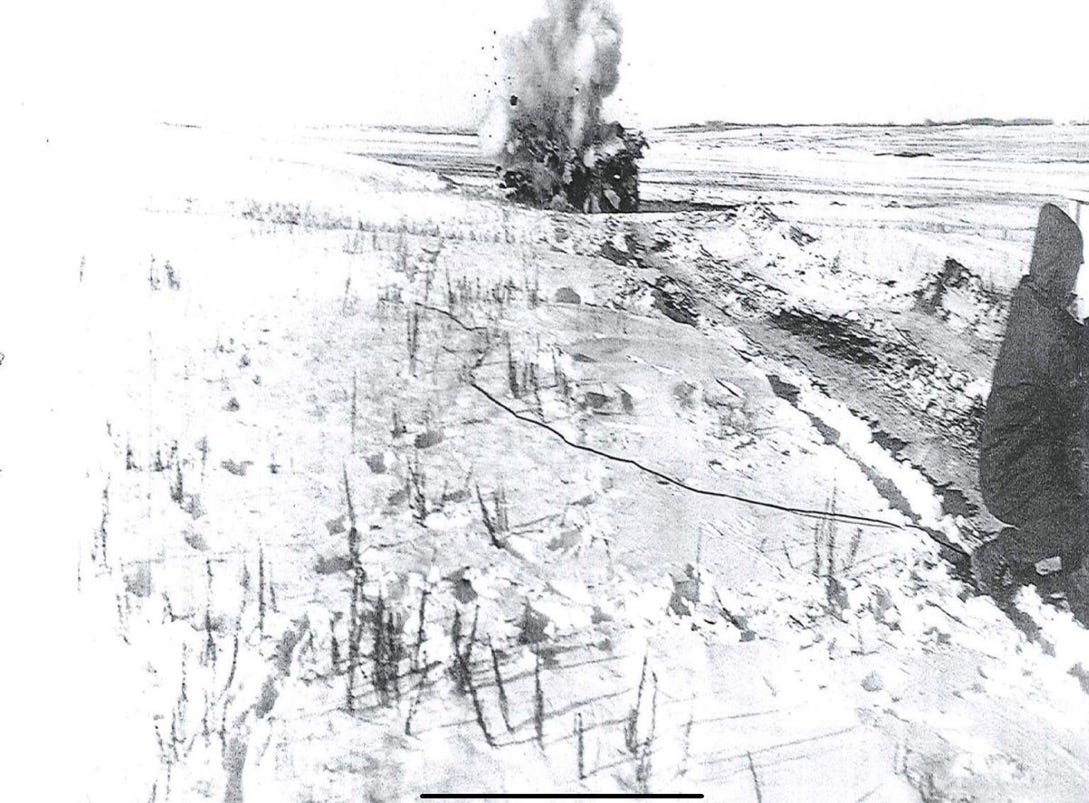
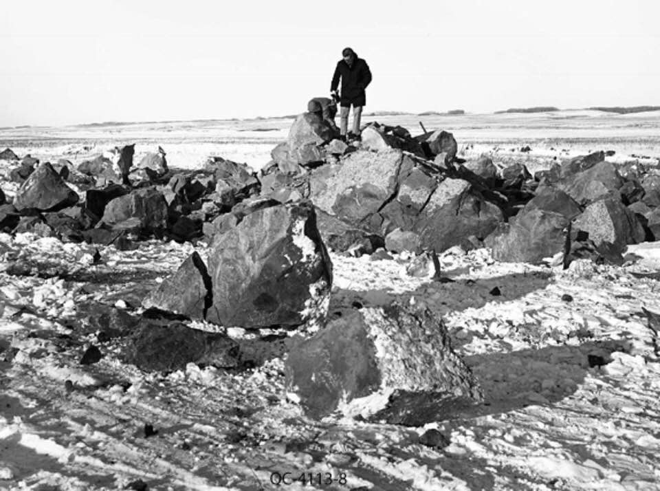
Fragments were later incorporated into a cairn at Elbow Harbour and a memorial to Chief Poundmaker on the Poundmaker Cree Nation reserve in the Cut Knife area. The remainder now lies submerged.
The name of the nearby town of Mistusinne is derived from the Cree word mistasiniy, meaning “big stone”. The stone was located on the floor of the Qu’Appelle Valley just east of the elbow of the South Saskatchewan River, 8 km southeast of the village of Elbow off Hwy 19, on the northeast shore of the Gordon McKenzie Arm of Lake Diefenbaker, Canada.
You may be viewing yesterday's version of this page. To see the most up to date information please register for a free account.


Do not use the above information on other web sites or publications without permission of the contributor.
Nearby Images from Flickr


The above images may not be of the site on this page, but were taken nearby. They are loaded from Flickr so please click on them for image credits.
Click here to see more info for this site
Nearby sites
Click here to view sites on an interactive map of the areaKey: Red: member's photo, Blue: 3rd party photo, Yellow: other image, Green: no photo - please go there and take one, Grey: site destroyed
Download sites to:
KML (Google Earth)
GPX (GPS waypoints)
CSV (Garmin/Navman)
CSV (Excel)
To unlock full downloads you need to sign up as a Contributory Member. Otherwise downloads are limited to 50 sites.
Turn off the page maps and other distractions
Nearby sites listing. In the following links * = Image available
6.2km NW 319° Mistaseni Cairn* Marker Stone
129.8km N 358° Wanuskewin Heritage Park* Museum
189.1km SSE 165° St.Victor Petroglyphs* Rock Art
246.0km SSE 148° Minton Deer Effigy* Rock Art
246.3km SSE 156° Blackfoot Buffalo Effigy* Rock Art
281.8km N 358° Park Valley Megalithic Stone Circle* Modern Stone Circle etc
302.5km WSW 241° Stampede Site* Ancient Mine, Quarry or other Industry
304.2km NNE 33° Nipawin Medicine Wheel Reconciliation Park* Ancient Village or Settlement
315.3km WSW 250° Saami Giant Teepee* Ancient Village or Settlement
399.2km WSW 254° Fincastle Grazing Reserve Bison Kill* Ancient Mine, Quarry or other Industry
415.6km W 265° Majorville Medicine Wheel* Round Cairn
423.5km WSW 241° Writing-on-Stone Provincial Park* Rock Art
450.6km W 259° Sundial Medicine Wheel* Ring Cairn
460.3km N 10° Lac La Ronge Rock Art Rock Art
475.6km NE 50° Kapakoskasewakak Lake stones Stone Row / Alignment
526.0km WSW 256° Head-Smashed-In Buffalo Jump* Ancient Mine, Quarry or other Industry
527.8km W 273° Ootssip'tomowa Look Out Hill* Hill Figure or Geoglyph
529.8km W 269° Big Rock (Alberta)* Rock Art
537.4km SW 224° First Peoples Buffalo Jump* Natural Stone / Erratic / Other Natural Feature
607.8km SSW 194° Pictograph Caves* Rock Art
615.5km SE 136° Double Ditch State Historic Site* Ancient Village or Settlement
639.3km SW 220° Megaliths Of Helena* Natural Stone / Erratic / Other Natural Feature
648.3km WSW 250° Crystal Lakes Golf Course Stonehenge* Modern Stone Circle etc
659.2km SSW 196° Valley of the Shields* Rock Art
688.6km SSW 193° Petroglyph Canyon (Cowley)* Rock Art
View more nearby sites and additional images


 We would like to know more about this location. Please feel free to add a brief description and any relevant information in your own language.
 Wir möchten mehr über diese Stätte erfahren. Bitte zögern Sie nicht, eine kurze Beschreibung und relevante Informationen in Deutsch hinzuzufügen.
 Nous aimerions en savoir encore un peu sur les lieux. S'il vous plaît n'hesitez pas à ajouter une courte description et tous les renseignements pertinents dans votre propre langue.
 Quisieramos informarnos un poco más de las lugares. No dude en añadir una breve descripción y otros datos relevantes en su propio idioma.