<< Our Photo Pages >> Kopiec Wandy - Artificial Mound in Poland in Malopolskie
Submitted by SolarMegalith on Sunday, 01 January 2012 Page Views: 3502
Multi-periodSite Name: Kopiec Wandy Alternative Name: Wanda's MoundCountry: Poland
NOTE: This site is 2.181 km away from the location you searched for.
Voivodeship: Malopolskie Type: Artificial Mound
Nearest Town: Krakow
Latitude: 50.070235N Longitude: 20.067911E
Condition:
| 5 | Perfect |
| 4 | Almost Perfect |
| 3 | Reasonable but with some damage |
| 2 | Ruined but still recognisable as an ancient site |
| 1 | Pretty much destroyed, possibly visible as crop marks |
| 0 | No data. |
| -1 | Completely destroyed |
| 5 | Superb |
| 4 | Good |
| 3 | Ordinary |
| 2 | Not Good |
| 1 | Awful |
| 0 | No data. |
| 5 | Can be driven to, probably with disabled access |
| 4 | Short walk on a footpath |
| 3 | Requiring a bit more of a walk |
| 2 | A long walk |
| 1 | In the middle of nowhere, a nightmare to find |
| 0 | No data. |
| 5 | co-ordinates taken by GPS or official recorded co-ordinates |
| 4 | co-ordinates scaled from a detailed map |
| 3 | co-ordinates scaled from a bad map |
| 2 | co-ordinates of the nearest village |
| 1 | co-ordinates of the nearest town |
| 0 | no data |
Internal Links:
External Links:
I have visited· I would like to visit
SolarMegalith visited on 31st Dec 2011 - their rating: Cond: 4 Amb: 3 Access: 5 The last archaeological monument which I have visited in 2011.
")
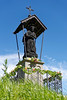
Kopiec Wandy („Wanda’s Mound”) is a late prehistoric artificial mound dated for 7th-8th century AD (Slavic tribal period). It is 14 m high and has 45-50 m in diameter. According to the legend it is a tomb of Wanda, the Slavic princess who committed suicide in waters of river Wisła. On top of the mound there is a stone monument with Wanda’s name. However, excavations of a similar mound in Kraków (Kopiec Krakusa) did not reveal any burials, just an Avarian metal artefact from 7th century AD.
In 1860 the mound has been surrounded with an Austrian earthen fort, which did not survive till nowadays.
Kopiec Wandy is well maintained and easily available – you can get there with lines 21 or 17 of tram in Kraków.
You may be viewing yesterday's version of this page. To see the most up to date information please register for a free account.
")
")
")
")
Do not use the above information on other web sites or publications without permission of the contributor.
Nearby Images from Flickr


The above images may not be of the site on this page, but were taken nearby. They are loaded from Flickr so please click on them for image credits.
Click here to see more info for this site
Nearby sites
Click here to view sites on an interactive map of the areaKey: Red: member's photo, Blue: 3rd party photo, Yellow: other image, Green: no photo - please go there and take one, Grey: site destroyed
Download sites to:
KML (Google Earth)
GPX (GPS waypoints)
CSV (Garmin/Navman)
CSV (Excel)
To unlock full downloads you need to sign up as a Contributory Member. Otherwise downloads are limited to 50 sites.
Turn off the page maps and other distractions
Nearby sites listing. In the following links * = Image available
8.6km WSW 245° Kopiec Krakusa* Artificial Mound
9.5km W 262° Archaeological Museum of Kraków* Museum
9.7km W 259° Kraków - Wawel* Ancient Village or Settlement
15.7km SSE 148° Kurhany Jawczyce Barrow Cemetery
17.3km SE 131° Kurhan Krakuszowice Round Barrow(s)
21.8km WNW 301° Jaskinia Mamutowa* Cave or Rock Shelter
21.9km WNW 302° Jaskinia Wierzchowska Górna* Cave or Rock Shelter
24.2km ESE 117° Grodzisko Łapczyca Hillfort
25.0km W 267° Grodzisko Mników Hillfort
25.8km WNW 296° Grodzisko Będkowice* Hillfort
26.7km WSW 251° Wołowice Flint Mine Ancient Mine, Quarry or other Industry
28.7km S 169° Grodzisko Poznachowice Górne* Hillfort
29.1km SSE 167° Grodzisko Klasztorzysko* Hillfort
31.2km NE 35° Kurhan Pałecznica Round Barrow(s)
32.4km WNW 285° Grodzisko Bartlowa Góra - Czatkowice Hillfort
36.5km NNE 31° Kurhan Szczotkowice Round Barrow(s)
38.0km SW 231° Grodzisko Bugaj* Hillfort
43.7km ESE 109° Grodzisko Jadowniki Podgórne* Hillfort
44.5km ENE 63° Kurhan Królewice* Round Barrow(s)
45.4km WNW 302° Grodzisko Stary Olkusz* Hillfort
46.7km NNW 333° Grodzisko Udórz Hillfort
46.9km WSW 239° Grodzisko Gorzeń Górny* Hillfort
47.7km SW 226° Grodzisko Zembrzyce* Promontory Fort / Cliff Castle
48.8km NW 324° Jaskinia Na Biśniku Cave or Rock Shelter
49.1km NE 54° Kurhany Kolosy* Round Barrow(s)
View more nearby sites and additional images


 We would like to know more about this location. Please feel free to add a brief description and any relevant information in your own language.
 Wir möchten mehr über diese Stätte erfahren. Bitte zögern Sie nicht, eine kurze Beschreibung und relevante Informationen in Deutsch hinzuzufügen.
 Nous aimerions en savoir encore un peu sur les lieux. S'il vous plaît n'hesitez pas à ajouter une courte description et tous les renseignements pertinents dans votre propre langue.
 Quisieramos informarnos un poco más de las lugares. No dude en añadir una breve descripción y otros datos relevantes en su propio idioma.