<< Our Photo Pages >> Gars-Thunau Hillfort - Hillfort in Austria
Submitted by klausschindl on Monday, 09 March 2009 Page Views: 7848
Iron Age and Later PrehistorySite Name: Gars-Thunau Hillfort Alternative Name: Thunau am KampCountry: Austria
NOTE: This site is 3.094 km away from the location you searched for.
Type: Hillfort
Nearest Town: Gars am Kamp
Latitude: 48.351990N Longitude: 15.385583E
Condition:
| 5 | Perfect |
| 4 | Almost Perfect |
| 3 | Reasonable but with some damage |
| 2 | Ruined but still recognisable as an ancient site |
| 1 | Pretty much destroyed, possibly visible as crop marks |
| 0 | No data. |
| -1 | Completely destroyed |
| 5 | Superb |
| 4 | Good |
| 3 | Ordinary |
| 2 | Not Good |
| 1 | Awful |
| 0 | No data. |
| 5 | Can be driven to, probably with disabled access |
| 4 | Short walk on a footpath |
| 3 | Requiring a bit more of a walk |
| 2 | A long walk |
| 1 | In the middle of nowhere, a nightmare to find |
| 0 | No data. |
| 5 | co-ordinates taken by GPS or official recorded co-ordinates |
| 4 | co-ordinates scaled from a detailed map |
| 3 | co-ordinates scaled from a bad map |
| 2 | co-ordinates of the nearest village |
| 1 | co-ordinates of the nearest town |
| 0 | no data |
Internal Links:
External Links:
")
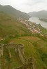
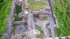
Hillfort in Lower Austria, close to Gars am Kamp.
Findings from late neolithic to early medieval times.
Biggest part of the still existing structures has been built in the early iron age. The Fort was important for merchants coming from all over central and eastern europe due to its ideal location. The city must have flourished until the slavs attacked and probably destroyed the fort.
Later an early christian slav church was erected at the cliffs of the end of the fort. It's foundations still remained until today. During excavations several in strange ways executed men and children have been found next to the church, usually the dead were buried at the nearby cemetary. The people might have been killed in a ritual.
The Fort is naturally protected from two sides.
The third side can be accessed through a steep path, where a gatehouse with tower hast been reconstructed. The foundations of the walls still existed and were built from expensive stone that had to be carried more than 100 km to the hillfort. This might show the wealth of this ancient settlement. The reconstrucion of the tower is incorrect, as stated by the local archaeologists.
The fourth side can be easily accessed and was heavily defended by very strong walls up to six meters high (2 meters and more can still be seen today) and more than 10 meters thick. The Frontside was a wood-stone-earth construcion that was burnt down during the erection to protect the wood from weathering and to harden it.
Altogether the site shows three gates.
Today the site is an important place for education of young archaeologists. Each year educational excavations take place in Thunau with mostly students from the Vienna Institute for Archaeology. To attract tourists several signposts with explanations have been erected.
Easy to find, easy to access, definitely worth a visit!
source a.o.: http://www.austriaca.at/?arp=0x0010f2a6
Maciej Karwowski, Thunau am Kamp – Eine befestigte Höhensiedlung (Grabung 1965–1990)
ISBN 978-3-7001-3603-3
You may be viewing yesterday's version of this page. To see the most up to date information please register for a free account.
")
Do not use the above information on other web sites or publications without permission of the contributor.
Nearby Images from Flickr


The above images may not be of the site on this page, but were taken nearby. They are loaded from Flickr so please click on them for image credits.
Click here to see more info for this site
Nearby sites
Click here to view sites on an interactive map of the areaKey: Red: member's photo, Blue: 3rd party photo, Yellow: other image, Green: no photo - please go there and take one, Grey: site destroyed
Download sites to:
KML (Google Earth)
GPX (GPS waypoints)
CSV (Garmin/Navman)
CSV (Excel)
To unlock full downloads you need to sign up as a Contributory Member. Otherwise downloads are limited to 50 sites.
Turn off the page maps and other distractions
Nearby sites listing. In the following links * = Image available
3.4km SSE 157° Venus of Willendorf* Ancient Village or Settlement
22.9km E 90° Urzeitmuseum* Museum
24.4km E 90° Gräberfeld Traisental* Barrow Cemetery
34.5km NW 316° Gross Gerungs Steinpyramide* Pyramid / Mastaba
38.2km NE 35° Mold and Rosenburg Ancient Settlements Ancient Village or Settlement
38.8km NW 315° Weltkugel* Natural Stone / Erratic / Other Natural Feature
40.7km NW 309° Summstein Thail* Modern Stone Circle etc
40.7km NW 309° Thail Opferstein* Natural Stone / Erratic / Other Natural Feature
41.2km NW 304° Wackelstein bei Harruck* Natural Stone / Erratic / Other Natural Feature
42.8km NW 324° Summstein Thaya* Modern Stone Circle etc
43.2km NW 312° Kierlingstein* Natural Stone / Erratic / Other Natural Feature
52.6km N 353° Grosse Basilica* Modern Stone Circle etc
53.1km NW 317° Steinernes Weib* Sculptured Stone
53.6km NNE 22° Summstein Geras* Modern Stone Circle etc
53.8km NE 40° Kalenderstein von Leodagger* Rock Art
54.6km NNW 342° Wolfsegg* Sculptured Stone
54.7km NNW 329° Cristophstein* Natural Stone / Erratic / Other Natural Feature
54.8km NNW 329° Wackelstein II Blockheide* Natural Stone / Erratic / Other Natural Feature
55.0km NNW 329° Schwedenkreuz* Ancient Cross
55.0km NNW 329° Teufelsbett Blockheide* Natural Stone / Erratic / Other Natural Feature
55.0km NNW 329° Teufelsbrotlaib* Natural Stone / Erratic / Other Natural Feature
55.0km NNW 329° Schuldstein* Natural Stone / Erratic / Other Natural Feature
55.1km NNW 330° Pilzstein* Natural Stone / Erratic / Other Natural Feature
55.2km NNW 330° Wackelstein III Blockheide* Natural Stone / Erratic / Other Natural Feature
55.6km NNW 329° Wackelstein I Blockheide* Natural Stone / Erratic / Other Natural Feature
View more nearby sites and additional images


 We would like to know more about this location. Please feel free to add a brief description and any relevant information in your own language.
 Wir möchten mehr über diese Stätte erfahren. Bitte zögern Sie nicht, eine kurze Beschreibung und relevante Informationen in Deutsch hinzuzufügen.
 Nous aimerions en savoir encore un peu sur les lieux. S'il vous plaît n'hesitez pas à ajouter une courte description et tous les renseignements pertinents dans votre propre langue.
 Quisieramos informarnos un poco más de las lugares. No dude en añadir una breve descripción y otros datos relevantes en su propio idioma.