<< Other Photo Pages >> Hat Rock (Kalapos-kő) - Rock Outcrop in Hungary
Submitted by Andy B on Thursday, 27 August 2020 Page Views: 984
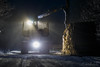
Natural PlacesSite Name: Hat Rock (Kalapos-kő)Country: Hungary
NOTE: This site is 7.436 km away from the location you searched for.
Type: Rock Outcrop
Nearest Town: Szombathely Nearest Village: Bozsok
Latitude: 47.332770N Longitude: 16.470140E
Condition:
| 5 | Perfect |
| 4 | Almost Perfect |
| 3 | Reasonable but with some damage |
| 2 | Ruined but still recognisable as an ancient site |
| 1 | Pretty much destroyed, possibly visible as crop marks |
| 0 | No data. |
| -1 | Completely destroyed |
| 5 | Superb |
| 4 | Good |
| 3 | Ordinary |
| 2 | Not Good |
| 1 | Awful |
| 0 | No data. |
| 5 | Can be driven to, probably with disabled access |
| 4 | Short walk on a footpath |
| 3 | Requiring a bit more of a walk |
| 2 | A long walk |
| 1 | In the middle of nowhere, a nightmare to find |
| 0 | No data. |
| 5 | co-ordinates taken by GPS or official recorded co-ordinates |
| 4 | co-ordinates scaled from a detailed map |
| 3 | co-ordinates scaled from a bad map |
| 2 | co-ordinates of the nearest village |
| 1 | co-ordinates of the nearest town |
| 0 | no data |
Internal Links:
External Links:
 (PID:215169)")
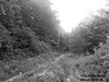
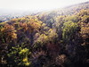
The Kőszeg Mountains form a ridge in a north to south direction. The tributaries of the Gyöngyös River created a system of valleys of west to east alignment. The interfluves between these valleys form secondary ridges with steep walls and locally even canyon-like morphology
The southern valley sides, built of greenschists and calcareous phyllite, show benches alternating with cliffs. On the interfluvial ridges spectacular rock formations are found, including the Kalapos-kő (Hat Rock, the name indicating its shape, widening upwards) on the high ridge stretching southwards from the Sötét Valley.
You may be viewing yesterday's version of this page. To see the most up to date information please register for a free account.
Do not use the above information on other web sites or publications without permission of the contributor.
Nearby Images from Flickr

The above images may not be of the site on this page, but were taken nearby. They are loaded from Flickr so please click on them for image credits.
Click here to see more info for this site
Nearby sites
Click here to view sites on an interactive map of the areaKey: Red: member's photo, Blue: 3rd party photo, Yellow: other image, Green: no photo - please go there and take one, Grey: site destroyed
Download sites to:
KML (Google Earth)
GPX (GPS waypoints)
CSV (Garmin/Navman)
CSV (Excel)
To unlock full downloads you need to sign up as a Contributory Member. Otherwise downloads are limited to 50 sites.
Turn off the page maps and other distractions
Nearby sites listing. In the following links * = Image available
34.6km NNW 347° Keltendorf Schwarzenbach Museum
34.9km NNW 347° Keltenwall Schwarzenbach Hillfort
38.9km W 271° Lochstein (Stambach) Holed Stone
39.9km W 280° Lochstein Kleinschlag Holed Stone
42.1km W 272° Pongratzen Menhir Standing Stone (Menhir)
52.5km WNW 282° Lochstein (Wenigzell) Holed Stone
64.0km N 11° Donnerskirchen Tumulus* Round Barrow(s)
82.1km NNW 338° Peilstein Berg Natural Stone / Erratic / Other Natural Feature
84.3km NNW 336° Hafnerberg Lochstein 1 Holed Stone
84.4km NNW 336° Hafnerberg Felsnadel Standing Stone (Menhir)
84.5km NNW 336° Hafnerberg Lochstein 2 Holed Stone
84.5km NNW 336° Hafnerberg Visurhügel 2 Round Barrow(s)
84.5km NNW 336° Hafnerberg Visurhügel 1 Round Barrow(s)
84.6km NNW 336° Fuxbauer Kalendarium Holed Stone
85.1km NNW 337° Hafnerberg Steinkreise Stone Circle
85.5km W 263° Repolusthöhle Cave or Rock Shelter
85.9km W 262° Römerweg Badl Ancient Trackway
95.1km NNE 32° Gerulata Ancient Village or Settlement
97.4km N 355° Naturhistorisches Museum Wien* Museum
102.4km N 357° Summstein Wasserpark* Modern Stone Circle etc
104.2km NNE 23° Villa Rustica Bratislava Dubravka Ancient Village or Settlement
106.5km SW 218° The Devil Stones (Maribor)* Natural Stone / Erratic / Other Natural Feature
114.1km N 2° Pillichsdorf Kalvarienberg Tumulus Round Barrow(s)
114.2km S 185° Varazdin Museum* Museum
114.4km NNE 23° Stupavsky hrad* Hillfort
View more nearby sites and additional images


 We would like to know more about this location. Please feel free to add a brief description and any relevant information in your own language.
 Wir möchten mehr über diese Stätte erfahren. Bitte zögern Sie nicht, eine kurze Beschreibung und relevante Informationen in Deutsch hinzuzufügen.
 Nous aimerions en savoir encore un peu sur les lieux. S'il vous plaît n'hesitez pas à ajouter une courte description et tous les renseignements pertinents dans votre propre langue.
 Quisieramos informarnos un poco más de las lugares. No dude en añadir una breve descripción y otros datos relevantes en su propio idioma.