<< Other Photo Pages >> Double Ditch State Historic Site - Ancient Village or Settlement in United States in The Plains
Submitted by partlow on Tuesday, 06 December 2016 Page Views: 20550
Multi-periodSite Name: Double Ditch State Historic Site Alternative Name: Fortified Mandan Village SiteCountry: United States
NOTE: This site is 17.351 km away from the location you searched for.
Region: The Plains Type: Ancient Village or Settlement
Nearest Town: Bismarck, N. Dakota
Latitude: 46.936170N Longitude: 100.90089W
Condition:
| 5 | Perfect |
| 4 | Almost Perfect |
| 3 | Reasonable but with some damage |
| 2 | Ruined but still recognisable as an ancient site |
| 1 | Pretty much destroyed, possibly visible as crop marks |
| 0 | No data. |
| -1 | Completely destroyed |
| 5 | Superb |
| 4 | Good |
| 3 | Ordinary |
| 2 | Not Good |
| 1 | Awful |
| 0 | No data. |
| 5 | Can be driven to, probably with disabled access |
| 4 | Short walk on a footpath |
| 3 | Requiring a bit more of a walk |
| 2 | A long walk |
| 1 | In the middle of nowhere, a nightmare to find |
| 0 | No data. |
| 5 | co-ordinates taken by GPS or official recorded co-ordinates |
| 4 | co-ordinates scaled from a detailed map |
| 3 | co-ordinates scaled from a bad map |
| 2 | co-ordinates of the nearest village |
| 1 | co-ordinates of the nearest town |
| 0 | no data |
Internal Links:
External Links:
")
Ken Kvamme, an associate professor of anthropology with the university has found the defensive system to have comprised of a rampart consisting of midden material, a palisade surrounding this, and two rings of double ditches around the palisade which is on the inside edge of the innermost ditch. The outermost ditch surrounded an area of approximately 7.5 hectares (18.75 acres); which according to Kvamme, posed an extreme engineering feat and exemplified a considerable state of fear for the village. Also bastions were found along the outer ditch and rectangular as well as circular lodges were found inside the ramparts.
The site was found to have been occupied from the early 1400s (based on the style of pottery sherds) into the 1700s and by the number of lodges, to have supported a population of approximately 3,000 people. There will be further dating by other techniques in the future. By standards of the region, so far, the site is found to be unusual due to the continuous occupation, tremendous size of site, and defensive works. Kvamme believes this site to be of World Heritage Site quality.
More at University of Arkansas news.
Official Web Site
Note: Work on North Dakota oil pipeline frozen following claims of damage to burial grounds sacred to The Standing Rock Sioux Tribe (not Double Ditch State Historic Site but within a few miles). Also news on repairs to flood damage to the state historic site, see the comments on our page
You may be viewing yesterday's version of this page. To see the most up to date information please register for a free account.
")
")
")
")
")
")
")
")
")
")
Do not use the above information on other web sites or publications without permission of the contributor.
Click here to see more info for this site
Nearby sites
Click here to view sites on an interactive map of the areaKey: Red: member's photo, Blue: 3rd party photo, Yellow: other image, Green: no photo - please go there and take one, Grey: site destroyed
Download sites to:
KML (Google Earth)
GPX (GPS waypoints)
CSV (Garmin/Navman)
CSV (Excel)
To unlock full downloads you need to sign up as a Contributory Member. Otherwise downloads are limited to 50 sites.
Turn off the page maps and other distractions
Nearby sites listing. In the following links * = Image available
231.6km E 88° Standing Rock State Historic Site* Artificial Mound
367.5km SW 225° Vore Buffalo Jump* Natural Stone / Erratic / Other Natural Feature
393.6km SW 230° Devil's Tower National Monument* Natural Stone / Erratic / Other Natural Feature
412.7km SW 227° Arch Creek Petroglyphs* Rock Art
419.9km SSE 147° Mitchell Site* Ancient Village or Settlement
430.3km E 84° Itasca Bison Kill* Natural Stone / Erratic / Other Natural Feature
432.6km E 83° Itasca Burial Mounds* Barrow Cemetery
477.5km ESE 118° Peterson Bison Kill Natural Stone / Erratic / Other Natural Feature
482.4km SE 131° Pipestone National Monument Ancient Mine, Quarry or other Industry
503.8km SSW 206° Hudson-Meng Bison Kill* Ancient Mine, Quarry or other Industry
512.4km SE 137° Blood Run Rock Art
515.1km SE 133° Blue Mounds Equinox Stone Alignment Stone Row / Alignment
525.3km NE 46° Bannock Point Petroforms* Stone Row / Alignment
542.7km ENE 67° Manitou Mounds* Barrow Cemetery
554.4km ESE 123° Jeffers Petroglyphs* Rock Art
555.1km SSW 197° Carhenge, Nebraska* Modern Stone Circle etc
565.8km ENE 69° Grand Mound* Artificial Mound
570.8km WSW 247° Falling Block* Natural Stone / Erratic / Other Natural Feature
575.4km ENE 69° McKinstry Mounds* Artificial Mound
577.0km ESE 103° Mahnomen Mounds Barrow Cemetery
584.8km SSW 212° Hell Gap* Ancient Village or Settlement
591.7km WSW 249° Bighorn Medicine Wheel* Stone Circle
593.1km W 260° Pictograph Caves* Rock Art
593.7km WSW 243° Medicine Lodge State Archeological Site* Rock Art
603.3km SW 223° Glenrock Buffalo Jump* Natural Stone / Erratic / Other Natural Feature
View more nearby sites and additional images


 We would like to know more about this location. Please feel free to add a brief description and any relevant information in your own language.
 Wir möchten mehr über diese Stätte erfahren. Bitte zögern Sie nicht, eine kurze Beschreibung und relevante Informationen in Deutsch hinzuzufügen.
 Nous aimerions en savoir encore un peu sur les lieux. S'il vous plaît n'hesitez pas à ajouter une courte description et tous les renseignements pertinents dans votre propre langue.
 Quisieramos informarnos un poco más de las lugares. No dude en añadir una breve descripción y otros datos relevantes en su propio idioma.
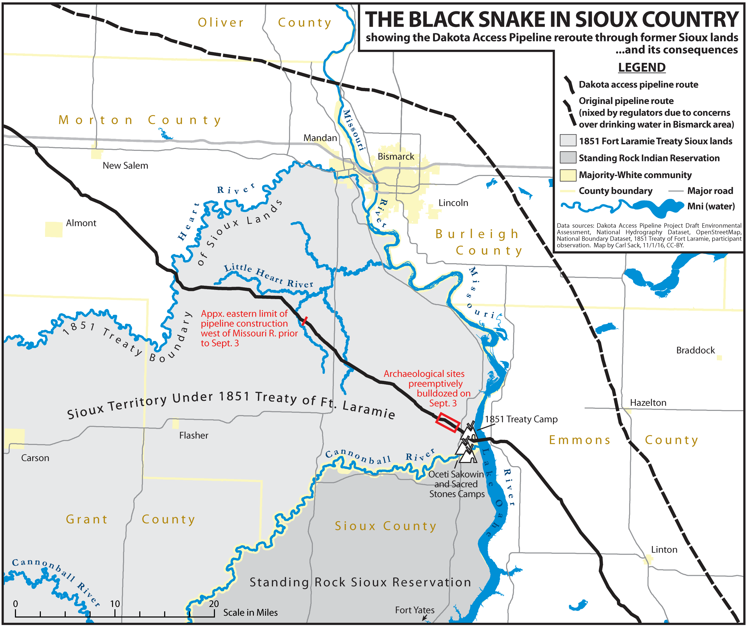