<< Image Pages >> Krapina Cave and Neanderthal Museum - Cave or Rock Shelter in Croatia
Submitted by durhamnature on Wednesday, 28 November 2012 Page Views: 6022
Natural PlacesSite Name: Krapina Cave and Neanderthal Museum Alternative Name: Husnjakova Hill CaveCountry: Croatia
NOTE: This site is 35.705 km away from the location you searched for.
Type: Cave or Rock Shelter
Nearest Town: Krapina
Latitude: 46.165506N Longitude: 15.864294E
Condition:
| 5 | Perfect |
| 4 | Almost Perfect |
| 3 | Reasonable but with some damage |
| 2 | Ruined but still recognisable as an ancient site |
| 1 | Pretty much destroyed, possibly visible as crop marks |
| 0 | No data. |
| -1 | Completely destroyed |
| 5 | Superb |
| 4 | Good |
| 3 | Ordinary |
| 2 | Not Good |
| 1 | Awful |
| 0 | No data. |
| 5 | Can be driven to, probably with disabled access |
| 4 | Short walk on a footpath |
| 3 | Requiring a bit more of a walk |
| 2 | A long walk |
| 1 | In the middle of nowhere, a nightmare to find |
| 0 | No data. |
| 5 | co-ordinates taken by GPS or official recorded co-ordinates |
| 4 | co-ordinates scaled from a detailed map |
| 3 | co-ordinates scaled from a bad map |
| 2 | co-ordinates of the nearest village |
| 1 | co-ordinates of the nearest town |
| 0 | no data |
Internal Links:
External Links:
")
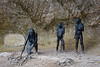
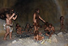
Important Neanderthal site in Croatia. There is parking at a prehistory museum which has exhibits from the cave and a garden with re-created Neanderthals and their prey animals. There is also a walk from here to the cave itself, which might not be an easy walk, as it is described as being closed in bad weather.
Possible, but unlikely evidence for cannibalism were discovered on Neanderthal bones from Krapina.
You may be viewing yesterday's version of this page. To see the most up to date information please register for a free account.
")
Do not use the above information on other web sites or publications without permission of the contributor.
Nearby Images from Flickr
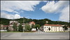
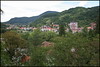
The above images may not be of the site on this page, but were taken nearby. They are loaded from Flickr so please click on them for image credits.
Click here to see more info for this site
Nearby sites
Click here to view sites on an interactive map of the areaKey: Red: member's photo, Blue: 3rd party photo, Yellow: other image, Green: no photo - please go there and take one, Grey: site destroyed
Download sites to:
KML (Google Earth)
GPX (GPS waypoints)
CSV (Garmin/Navman)
CSV (Excel)
To unlock full downloads you need to sign up as a Contributory Member. Otherwise downloads are limited to 50 sites.
Turn off the page maps and other distractions
Nearby sites listing. In the following links * = Image available
39.3km ENE 66° Varazdin Museum* Museum
40.4km SSE 167° Zagreb Archeological Museum* Museum
49.4km NNW 337° The Devil Stones (Maribor)* Natural Stone / Erratic / Other Natural Feature
72.1km NW 323° Lochstein Wuggitz Holed Stone
85.4km SSE 152° Sisak Ancient Village or Settlement
99.0km W 264° Čolnišče Prehistoric Trap* Ancient Village or Settlement
124.2km NNW 341° Römerweg Badl Ancient Trackway
124.6km NNW 342° Repolusthöhle Cave or Rock Shelter
130.3km N 3° Lochstein (Stambach) Holed Stone
131.0km N 2° Pongratzen Menhir Standing Stone (Menhir)
136.7km N 3° Lochstein Kleinschlag Holed Stone
137.8km NNE 19° Hat Rock (Kalapos-kő)* Rock Outcrop
140.2km N 358° Lochstein (Wenigzell) Holed Stone
148.9km WNW 289° Keltenwelt Froeg-Rosegg Museum
165.8km SW 226° Tramuntana Dolmen 1* Burial Chamber or Dolmen
165.9km SW 226° Beli wall petroglyph* Rock Art
166.2km SW 226° Tramuntana Dolmen 2* Burial Chamber or Dolmen
167.1km SW 226° Tramuntana Well* Holy Well or Sacred Spring
167.1km SW 226° Tramuntana Portal Tomb* Portal Tomb
167.8km NNE 13° Keltendorf Schwarzenbach Museum
168.1km NNE 13° Keltenwall Schwarzenbach Hillfort
168.5km WSW 257° Debela Griža Hillfort
179.1km SW 229° Kunci Hillfort* Hillfort
180.9km SW 229° Labin Museum* Museum
198.5km SW 228° Mutvoran Hillfort* Hillfort
View more nearby sites and additional images


 We would like to know more about this location. Please feel free to add a brief description and any relevant information in your own language.
 Wir möchten mehr über diese Stätte erfahren. Bitte zögern Sie nicht, eine kurze Beschreibung und relevante Informationen in Deutsch hinzuzufügen.
 Nous aimerions en savoir encore un peu sur les lieux. S'il vous plaît n'hesitez pas à ajouter une courte description et tous les renseignements pertinents dans votre propre langue.
 Quisieramos informarnos un poco más de las lugares. No dude en añadir una breve descripción y otros datos relevantes en su propio idioma.