<< Other Photo Pages >> Perch Lake mounds - Artificial Mound in United States in New England
Submitted by Andy B on Sunday, 30 July 2023 Page Views: 644
Pre-ColumbianSite Name: Perch Lake mounds Alternative Name: Hyde CreekCountry: United States
NOTE: This site is 79.276 km away from the location you searched for.
Region: New England Type: Artificial Mound
Latitude: 44.123820N Longitude: 75.89267W
Condition:
| 5 | Perfect |
| 4 | Almost Perfect |
| 3 | Reasonable but with some damage |
| 2 | Ruined but still recognisable as an ancient site |
| 1 | Pretty much destroyed, possibly visible as crop marks |
| 0 | No data. |
| -1 | Completely destroyed |
| 5 | Superb |
| 4 | Good |
| 3 | Ordinary |
| 2 | Not Good |
| 1 | Awful |
| 0 | No data. |
| 5 | Can be driven to, probably with disabled access |
| 4 | Short walk on a footpath |
| 3 | Requiring a bit more of a walk |
| 2 | A long walk |
| 1 | In the middle of nowhere, a nightmare to find |
| 0 | No data. |
| 5 | co-ordinates taken by GPS or official recorded co-ordinates |
| 4 | co-ordinates scaled from a detailed map |
| 3 | co-ordinates scaled from a bad map |
| 2 | co-ordinates of the nearest village |
| 1 | co-ordinates of the nearest town |
| 0 | no data |
Internal Links:
External Links:
")
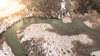
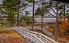
A large, unusual group of non-mortuary mounds at Perch Lake, east of Lake Ontario in northern New York State. The Perch Lake mounds are annular features that have long been objects of interest, but their purpose has remained enigmatic. An early estimate placed their number at 200, and upwards of 40 of them still remain in a well-preserved state.
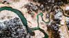
Typically the mounds are circular, symmetrical rings 10 m in diameter and 0.6 m high, with central depressions 2.5 m across. A recent pilot study of a mound built ca. 2,000 years ago showed that the ring portion is made of earth and stone and that the central depression contains much wood charcoal and fire-altered rock.
Over the years many of the mounds have been partially opened, but no human remains have ever been found. Very few artifacts have been reported and no food refuse. Indeed it is the lack of such materials that has made past attempts at interpretation open to question and relegated the mounds to obscurity.
At least 13 hypotheses regarding how the mounds were used have been proposed; these range widely from mounds serving primarily ritual functions, to lodges with perishable superstructures, to food processing facilities. Few of the hypotheses can be rejected conclusively on the basis of available information, and new field-based investigations are needed to address deficiencies in the current knowledge about the mounds.
Source: https://www.nsf.gov/awardsearch/showAward?AWD_ID=0741361
You may be viewing yesterday's version of this page. To see the most up to date information please register for a free account.
")
")
")
Do not use the above information on other web sites or publications without permission of the contributor.
Nearby Images from Flickr


The above images may not be of the site on this page, but were taken nearby. They are loaded from Flickr so please click on them for image credits.
Click here to see more info for this site
Nearby sites
Click here to view sites on an interactive map of the areaKey: Red: member's photo, Blue: 3rd party photo, Yellow: other image, Green: no photo - please go there and take one, Grey: site destroyed
Download sites to:
KML (Google Earth)
GPX (GPS waypoints)
CSV (Garmin/Navman)
CSV (Excel)
To unlock full downloads you need to sign up as a Contributory Member. Otherwise downloads are limited to 50 sites.
Turn off the page maps and other distractions
Nearby sites listing. In the following links * = Image available
61.0km NNE 21° Maitland Tower* Modern Stone Circle etc
145.9km N 6° Canadian Museum of History* Museum
167.0km ENE 61° Earthwood new stone circle Modern Stone Circle etc
178.5km WNW 288° Petroglyphs Provincial Park (Ontario)* Rock Art
180.6km W 274° Serpent Mound, Keene* Misc. Earthwork
196.4km ENE 67° Earthwood Modern Stone Circle Modern Stone Circle etc
209.0km WNW 282° Jacob's Island Mound Barrow Cemetery
240.9km NE 49° Charles De Gaulle Obelisk* Modern Stone Circle etc
242.7km SSW 193° Spanish Hill* Artificial Mound
269.9km E 79° Elmore Balancing Rock* Natural Stone / Erratic / Other Natural Feature
271.0km WNW 288° Lewiston Mound State Park* Artificial Mound
276.5km ESE 102° Calendar II* Artificial Mound
277.8km SE 129° Balance Stone Lanesborough Natural Stone / Erratic / Other Natural Feature
279.5km SE 131° EarthGate Circle Modern Stone Circle etc
282.5km ENE 72° Balancing Stone Westfield Natural Stone / Erratic / Other Natural Feature
285.6km SSE 147° The King Stones Stone Circle
291.2km E 98° Humming Stone Norwich (Summstein) Modern Stone Circle etc
297.7km ESE 122° Burnt Hill Heath* Stone Circle
298.8km ESE 110° Bellows Falls Petroglyphs* Rock Art
303.4km ESE 116° Brattleboro Petroglyphs Rock Art
305.5km ESE 117° Humming Stone Guilford (Summstein) Modern Stone Circle etc
311.3km SE 126° Balanced rock Goshen* Natural Stone / Erratic / Other Natural Feature
313.4km SE 139° Giant's Thumb and mound* Standing Stone (Menhir)
314.5km SW 223° Stone of Rock City Park Natural Stone / Erratic / Other Natural Feature
321.3km ESE 121° Turner's Falls Standing Stones
View more nearby sites and additional images


 We would like to know more about this location. Please feel free to add a brief description and any relevant information in your own language.
 Wir möchten mehr über diese Stätte erfahren. Bitte zögern Sie nicht, eine kurze Beschreibung und relevante Informationen in Deutsch hinzuzufügen.
 Nous aimerions en savoir encore un peu sur les lieux. S'il vous plaît n'hesitez pas à ajouter une courte description et tous les renseignements pertinents dans votre propre langue.
 Quisieramos informarnos un poco más de las lugares. No dude en añadir una breve descripción y otros datos relevantes en su propio idioma.