<< Text Pages >> Almerge - Castro or Chafurdão in Spain in Aragón
Submitted by TheCaptain on Wednesday, 08 September 2010 Page Views: 2017
Iron Age and Later PrehistorySite Name: AlmergeCountry: Spain
NOTE: This site is 6.656 km away from the location you searched for.
Region: Aragón Type: Castro or Chafurdão
Nearest Town: Huesca Nearest Village: Laluenga
Latitude: 42.004000N Longitude: 0.047W
Condition:
| 5 | Perfect |
| 4 | Almost Perfect |
| 3 | Reasonable but with some damage |
| 2 | Ruined but still recognisable as an ancient site |
| 1 | Pretty much destroyed, possibly visible as crop marks |
| 0 | No data. |
| -1 | Completely destroyed |
| 5 | Superb |
| 4 | Good |
| 3 | Ordinary |
| 2 | Not Good |
| 1 | Awful |
| 0 | No data. |
| 5 | Can be driven to, probably with disabled access |
| 4 | Short walk on a footpath |
| 3 | Requiring a bit more of a walk |
| 2 | A long walk |
| 1 | In the middle of nowhere, a nightmare to find |
| 0 | No data. |
| 5 | co-ordinates taken by GPS or official recorded co-ordinates |
| 4 | co-ordinates scaled from a detailed map |
| 3 | co-ordinates scaled from a bad map |
| 2 | co-ordinates of the nearest village |
| 1 | co-ordinates of the nearest town |
| 0 | no data |
Be the first person to rate this site - see the 'Contribute!' box in the right hand menu.
Internal Links:
External Links:
Castro in Aragon
Almerge is a Castro in the community of Laluenga, Province of Huesca, region of Aragon
You may be viewing yesterday's version of this page. To see the most up to date information please register for a free account.
Do not use the above information on other web sites or publications without permission of the contributor.
Nearby Images from Flickr

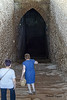
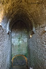

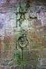

The above images may not be of the site on this page, but were taken nearby. They are loaded from Flickr so please click on them for image credits.
Click here to see more info for this site
Nearby sites
Click here to view sites on an interactive map of the areaKey: Red: member's photo, Blue: 3rd party photo, Yellow: other image, Green: no photo - please go there and take one, Grey: site destroyed
Download sites to:
KML (Google Earth)
GPX (GPS waypoints)
CSV (Garmin/Navman)
CSV (Excel)
To unlock full downloads you need to sign up as a Contributory Member. Otherwise downloads are limited to 50 sites.
Turn off the page maps and other distractions
Nearby sites listing. In the following links * = Image available
9.3km ESE 107° Fornillos Castro or Chafurdão
15.8km ESE 107° Castejon del Puente Castro or Chafurdão
21.9km NNE 13° Abrigo de Quizans Rock Art
22.9km NNE 14° Chimiachas* Cave or Rock Shelter
26.1km NNW 341° Cueva de Chaves Cave or Rock Shelter
28.8km NNW 332° Piedrafita Dolmen* Burial Chamber or Dolmen
29.1km NNW 332° Articasales Dolmen* Burial Chamber or Dolmen
29.7km ENE 79° Forau del Cocho Rock Art
29.9km ENE 67° Remosillo Pinturas Rupestres Rock Art
30.4km E 81° Coveta de l'Engardaixo Cave or Rock Shelter
32.3km NNE 16° Caseta de las Balanzas Dolmen* Burial Chamber or Dolmen
33.7km N 354° Losa Mora Dolmen* Burial Chamber or Dolmen
34.1km NNE 15° Pueyoril Dolmen* Burial Chamber or Dolmen
34.4km NNE 13° La Capilleta Dolmen* Burial Chamber or Dolmen
37.9km NNW 330° Palomar Dolmen Burial Chamber or Dolmen
41.5km NW 318° La Piatra Dolmen* Burial Chamber or Dolmen
41.7km ESE 111° Tamarite Castro or Chafurdão
41.8km ENE 74° Dolmen de Mas del Abad* Burial Chamber or Dolmen
41.8km ENE 74° Menhir Mas d'Abad Standing Stone (Menhir)
42.0km ENE 74° Mas de Abad* Burial Chamber or Dolmen
42.3km NNW 337° Ibirque Dolmen* Burial Chamber or Dolmen
42.4km ENE 75° San Salvador Dolmen* Burial Chamber or Dolmen
43.2km ENE 76° Dolmen del Mas de Balón Burial Chamber or Dolmen
44.2km NE 45° Dolmen de Perarrúa Burial Chamber or Dolmen
57.3km E 83° Dolmen d'Estall Sud Burial Chamber or Dolmen
View more nearby sites and additional images


 We would like to know more about this location. Please feel free to add a brief description and any relevant information in your own language.
 Wir möchten mehr über diese Stätte erfahren. Bitte zögern Sie nicht, eine kurze Beschreibung und relevante Informationen in Deutsch hinzuzufügen.
 Nous aimerions en savoir encore un peu sur les lieux. S'il vous plaît n'hesitez pas à ajouter une courte description et tous les renseignements pertinents dans votre propre langue.
 Quisieramos informarnos un poco más de las lugares. No dude en añadir una breve descripción y otros datos relevantes en su propio idioma.