<< Our Photo Pages >> Dio. - Ancient Village or Settlement in Greece in Northern Greece
Submitted by AlexHunger on Sunday, 12 November 2006 Page Views: 4319
Multi-periodSite Name: Dio. Alternative Name: DionCountry: Greece
NOTE: This site is 7.94 km away from the location you searched for.
Region: Northern Greece Type: Ancient Village or Settlement
Nearest Town: Katerini Nearest Village: Dion
Latitude: 40.176541N Longitude: 22.492320E
Condition:
| 5 | Perfect |
| 4 | Almost Perfect |
| 3 | Reasonable but with some damage |
| 2 | Ruined but still recognisable as an ancient site |
| 1 | Pretty much destroyed, possibly visible as crop marks |
| 0 | No data. |
| -1 | Completely destroyed |
| 5 | Superb |
| 4 | Good |
| 3 | Ordinary |
| 2 | Not Good |
| 1 | Awful |
| 0 | No data. |
| 5 | Can be driven to, probably with disabled access |
| 4 | Short walk on a footpath |
| 3 | Requiring a bit more of a walk |
| 2 | A long walk |
| 1 | In the middle of nowhere, a nightmare to find |
| 0 | No data. |
| 5 | co-ordinates taken by GPS or official recorded co-ordinates |
| 4 | co-ordinates scaled from a detailed map |
| 3 | co-ordinates scaled from a bad map |
| 2 | co-ordinates of the nearest village |
| 1 | co-ordinates of the nearest town |
| 0 | no data |
Internal Links:
External Links:
I have visited· I would like to visit
bat400 visited on 1st May 2011 - their rating: Cond: 2 Amb: 4 Access: 4 An understated site that takes some walking and contemplation to even hope to understand. Well signed, but be sure to visit the museum in the village in order to fully appreciate Dion.
davidmorgan have visited here
")
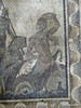
Ancient settlement, later used by the Romans with 2 theatres, among other ruins.
You may be viewing yesterday's version of this page. To see the most up to date information please register for a free account.
Do not use the above information on other web sites or publications without permission of the contributor.
Nearby Images from Flickr
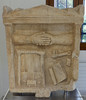
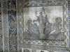
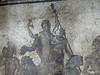
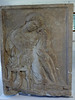

The above images may not be of the site on this page, but were taken nearby. They are loaded from Flickr so please click on them for image credits.
Click here to see more info for this site
Nearby sites
Click here to view sites on an interactive map of the areaKey: Red: member's photo, Blue: 3rd party photo, Yellow: other image, Green: no photo - please go there and take one, Grey: site destroyed
Download sites to:
KML (Google Earth)
GPX (GPS waypoints)
CSV (Garmin/Navman)
CSV (Excel)
To unlock full downloads you need to sign up as a Contributory Member. Otherwise downloads are limited to 50 sites.
Turn off the page maps and other distractions
Nearby sites listing. In the following links * = Image available
25.3km NNE 26° Pydna* Ancient Village or Settlement
36.5km NNW 337° Vergina* Ancient Village or Settlement
37.5km NNW 337° Tomb of Philip II* Chambered Cairn
59.0km NE 40° Karabournaki* Ancient Village or Settlement
60.0km S 186° Larissa (Thessaly)* Ancient Village or Settlement
60.5km NNW 327° School of Aristotle* NOT SET
60.6km NNW 327° Mieza* Ancient Village or Settlement
61.0km NNW 331° Fleurons Macedonian Tomb* Chambered Tomb
61.1km NNW 331° Krisis Macedonian Tomb* Chambered Tomb
61.1km NNW 330° Kinch's Macedonian Tomb* Chambered Tomb
61.3km NNW 330° Lyson and Kallicleus Macedonian Tomb* Chambered Tomb
64.4km N 2° Pella (Greece)* Ancient Village or Settlement
67.8km N 358° Giannitsa Archontikon* Ancient Village or Settlement
78.1km NNW 332° Edessa* Ancient Village or Settlement
79.2km ESE 107° Temple of Poseidon, Posseidi* Ancient Temple
81.6km E 97° Amon Temple of Zeus Ancient Temple
82.1km E 97° Aphitis Temple of Zeus Ammon Ancient Temple
88.6km SW 232° Theopetra Cave Cave or Rock Shelter
89.6km SW 235° Metéora* Natural Stone / Erratic / Other Natural Feature
90.1km SSE 166° Pherai* Ancient Temple
96.0km SSE 162° Sesklo* Ancient Village or Settlement
96.7km SSE 159° Dimini Mycenaean Tholos* Cairn
96.8km SSE 159° Dimini* Ancient Village or Settlement
100.1km SSE 158° Demetria Temple* Ancient Temple
107.7km S 189° Koutroulou Magoula* Ancient Village or Settlement
View more nearby sites and additional images

")
 We would like to know more about this location. Please feel free to add a brief description and any relevant information in your own language.
 Wir möchten mehr über diese Stätte erfahren. Bitte zögern Sie nicht, eine kurze Beschreibung und relevante Informationen in Deutsch hinzuzufügen.
 Nous aimerions en savoir encore un peu sur les lieux. S'il vous plaît n'hesitez pas à ajouter une courte description et tous les renseignements pertinents dans votre propre langue.
 Quisieramos informarnos un poco más de las lugares. No dude en añadir una breve descripción y otros datos relevantes en su propio idioma.