<< Our Photo Pages >> Truckhenge - Modern Stone Circle etc in United States in The Plains
Submitted by Andy B on Thursday, 01 October 2009 Page Views: 80068
Modern SitesSite Name: TruckhengeCountry: United States
NOTE: This site is 148.891 km away from the location you searched for.
Region: The Plains Type: Modern Stone Circle etc
Nearest Town: Topeka
Latitude: 39.076176N Longitude: 95.606192W
Condition:
| 5 | Perfect |
| 4 | Almost Perfect |
| 3 | Reasonable but with some damage |
| 2 | Ruined but still recognisable as an ancient site |
| 1 | Pretty much destroyed, possibly visible as crop marks |
| 0 | No data. |
| -1 | Completely destroyed |
| 5 | Superb |
| 4 | Good |
| 3 | Ordinary |
| 2 | Not Good |
| 1 | Awful |
| 0 | No data. |
| 5 | Can be driven to, probably with disabled access |
| 4 | Short walk on a footpath |
| 3 | Requiring a bit more of a walk |
| 2 | A long walk |
| 1 | In the middle of nowhere, a nightmare to find |
| 0 | No data. |
| 5 | co-ordinates taken by GPS or official recorded co-ordinates |
| 4 | co-ordinates scaled from a detailed map |
| 3 | co-ordinates scaled from a bad map |
| 2 | co-ordinates of the nearest village |
| 1 | co-ordinates of the nearest town |
| 0 | no data |
Internal Links:
External Links:
I have visited· I would like to visit
Andy B has visited here
")
Ron has been working on Truckhenge for about six years.
There are six trucks standing on end, buried four feet into the ground. Ron, who lives in a flood plane, must ensure the trucks won't float away.
"I put four, 3,000-pound blocks, two or four yards of concrete, two scoops of gravel, which was 4,000 pounds to a scoop of gravel. And then there was a ton of iron in each one of 'em."
The trucks date to the 1940s and '50s. Ron got them from a neighbor.
"I didn't see like throwing them away 'cause they're just too nice a specimens for trucks."
There is a colorful "Zoned to Speak Out" sign on the property and the trucks are painted with various quotes, "Rise up" and "Vote," among others.
Ron even has a Beer Bottle City, a sculptures made of thousands of bottles.
"There's 3,000 in the first one and 1,800 in the next two."
Ron received a plaque from Shawnee County Recycling and Preservation for his recycling mastery.
Ron has a sense of humor about his distinctive art.
"The bumpers, well, anybody has a question about me being a farmer. I got a bumper crop."
So why does Ron like doing this.
"Well, you gotta distinguish yourself," Ron said.
Additional info:
Truckhenge is open to the public. Ron Lessman's Truckhenge is located at 4124 N.E. Brier Road in Topeka. If you would like a tour, call Ron at (785) 234-3486.
"Truckhenge is an expression of loving this country," he said. "It's about expression of life."
Source: 49ABC News.
Note: Trucktoberfest Music festival, October 3rd, see latest comment
You may be viewing yesterday's version of this page. To see the most up to date information please register for a free account.
")
")
")
")
Do not use the above information on other web sites or publications without permission of the contributor.
Nearby Images from Flickr


The above images may not be of the site on this page, but were taken nearby. They are loaded from Flickr so please click on them for image credits.
Click here to see more info for this site
Nearby sites
Click here to view sites on an interactive map of the areaKey: Red: member's photo, Blue: 3rd party photo, Yellow: other image, Green: no photo - please go there and take one, Grey: site destroyed
Download sites to:
KML (Google Earth)
GPX (GPS waypoints)
CSV (Garmin/Navman)
CSV (Excel)
To unlock full downloads you need to sign up as a Contributory Member. Otherwise downloads are limited to 50 sites.
Turn off the page maps and other distractions
Nearby sites listing. In the following links * = Image available
203.1km E 84° Old Fort (Miami, MO)* Artificial Mound
217.3km SE 133° Big Eddy* Ancient Mine, Quarry or other Industry
259.6km SSW 209° Etzanoa* Ancient Village or Settlement
267.9km E 92° Big Moniteau Rock Art
269.4km SE 144° Horseshoe Fossil Spring Ancient Village or Settlement
280.0km E 95° BoatHenge, Missouri* Modern Stone Circle etc
282.5km ENE 63° Thousand Hills Petroglyphs* Rock Art
301.7km S 169° Spavinaw Creek Ancient Village or Settlement
327.3km NNE 31° The Palace Ancient Village or Settlement
329.4km NNE 33° Yellow Banks Park* Artificial Mound
348.9km E 92° Graham Cave* Cave or Rock Shelter
355.7km ESE 109° UMR Stonehenge* Modern Stone Circle etc
372.1km ENE 74° Indian Mounds Park* Artificial Mound
402.5km N 1° Pilot Rock (Cherokee)* Natural Stone / Erratic / Other Natural Feature
408.6km N 1° Sanford Museum* Museum
427.8km E 93° Schwendemann Farm Mound Artificial Mound
428.5km SSE 167° Spiro Mounds Archaeological Park* Ancient Village or Settlement
431.3km E 79° Elizabeth Mound Complex* Barrow Cemetery
431.5km SSE 165° Cavanaugh* Artificial Mound
435.6km E 81° Montezuma Mound Group* Artificial Mound
437.5km E 90° Pere Marquette State Park* Artificial Mound
439.7km E 94° Blake Mound Artificial Mound
442.0km ESE 103° Washington State Park Petroglyphs* Rock Art
445.9km SW 233° Badger Hole (Oklahoma)* Ancient Mine, Quarry or other Industry
450.8km ENE 58° Toolesboro Mound Group* Artificial Mound
View more nearby sites and additional images


 We would like to know more about this location. Please feel free to add a brief description and any relevant information in your own language.
 Wir möchten mehr über diese Stätte erfahren. Bitte zögern Sie nicht, eine kurze Beschreibung und relevante Informationen in Deutsch hinzuzufügen.
 Nous aimerions en savoir encore un peu sur les lieux. S'il vous plaît n'hesitez pas à ajouter une courte description et tous les renseignements pertinents dans votre propre langue.
 Quisieramos informarnos un poco más de las lugares. No dude en añadir una breve descripción y otros datos relevantes en su propio idioma.
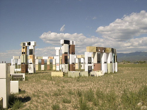