<< Our Photo Pages >> NamhanSanseong - Hillfort in South Korea
Submitted by Aska on Wednesday, 17 October 2018 Page Views: 1042
Iron Age and Later PrehistorySite Name: NamhanSanseong Alternative Name: 남한산성 南漢山城Country: South Korea
NOTE: This site is 0.405 km away from the location you searched for.
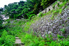
Type: Hillfort
Nearest Town: Gwangju-si (광주시) Nearest Village: Jungbu-myeon Sanseong-ri (중ዳ
Latitude: 37.481630N Longitude: 127.184850E
Condition:
| 5 | Perfect |
| 4 | Almost Perfect |
| 3 | Reasonable but with some damage |
| 2 | Ruined but still recognisable as an ancient site |
| 1 | Pretty much destroyed, possibly visible as crop marks |
| 0 | No data. |
| -1 | Completely destroyed |
| 5 | Superb |
| 4 | Good |
| 3 | Ordinary |
| 2 | Not Good |
| 1 | Awful |
| 0 | No data. |
| 5 | Can be driven to, probably with disabled access |
| 4 | Short walk on a footpath |
| 3 | Requiring a bit more of a walk |
| 2 | A long walk |
| 1 | In the middle of nowhere, a nightmare to find |
| 0 | No data. |
| 5 | co-ordinates taken by GPS or official recorded co-ordinates |
| 4 | co-ordinates scaled from a detailed map |
| 3 | co-ordinates scaled from a bad map |
| 2 | co-ordinates of the nearest village |
| 1 | co-ordinates of the nearest town |
| 0 | no data |
Internal Links:
External Links:
")
In the northern mountain of Seoul city, there lies another fortress called BukhanSanseong (북한산성), Buk=north Nam=south, which was built in 1711.
Get off at Seoul city subway no.8 line Sanseong (=mountain fortress) station then go out through the exit no.2 and take nos.9, 9-1 or 52 bus. The terminal of the bus is in the centre of the fortress where the information office (English brochure available) and Korean restaurants are waiting for you. Whole trip along the long wall with severe up-and-down will take 3.5-4 hours, but you will see so many Korean people dare to complete the trip. Designated as No. 57 of National Historic Site
You may be viewing yesterday's version of this page. To see the most up to date information please register for a free account.
")
")
Do not use the above information on other web sites or publications without permission of the contributor.
Nearby Images from Flickr


The above images may not be of the site on this page, but were taken nearby. They are loaded from Flickr so please click on them for image credits.
Click here to see more info for this site
Nearby sites
Click here to view sites on an interactive map of the areaKey: Red: member's photo, Blue: 3rd party photo, Yellow: other image, Green: no photo - please go there and take one, Grey: site destroyed
Download sites to:
KML (Google Earth)
GPX (GPS waypoints)
CSV (Garmin/Navman)
CSV (Excel)
To unlock full downloads you need to sign up as a Contributory Member. Otherwise downloads are limited to 50 sites.
Turn off the page maps and other distractions
Nearby sites listing. In the following links * = Image available
6.6km WNW 296° Bangi-dong gobungun* Round Barrow(s)
7.0km NW 304° MongchonToseong* Hillfort
7.7km WNW 289° Seokchon-dong gobungun* Chambered Cairn
8.5km NW 319° BungnapToseong* Hillfort
9.5km WSW 252° 수송리 Burial Chamber or Dolmen
10.1km NNW 333° Seoul Amsa-dong prehistoric Sites* Ancient Village or Settlement
10.9km NW 319° AchasanSeong* Hillfort
11.8km ESE 114° 상자포리 Burial Chamber or Dolmen
13.0km SSW 201° 양구리 Burial Chamber or Dolmen
18.7km WNW 285° National Museum of Korea* Museum
25.0km NNW 349° 가락동 Burial Chamber or Dolmen
26.6km ESE 108° 후남리 Burial Chamber or Dolmen
29.4km SW 215° 조부리 Burial Chamber or Dolmen
29.4km WSW 256° Gahakdong dolmens* Burial Chamber or Dolmen
37.6km NW 324° 역삼동 Burial Chamber or Dolmen
46.3km ESE 108° Seogu-ri Menhir* Standing Stone (Menhir)
48.7km SE 129° Cheo-ri Menhir* Standing Stone (Menhir)
59.2km WNW 295° GoJeong-ri dolmens* Burial Chamber or Dolmen
69.0km WNW 297° Daesan-ni goindol* Burial Chamber or Dolmen
71.1km N 9° 양수리 Burial Chamber or Dolmen
71.1km WSW 247° Dukun-ri Dolmens* Burial Chamber or Dolmen
72.8km WNW 294° Gocheon-ni goindolgun* Burial Chamber or Dolmen
73.0km WNW 297° Bugeun-ni goindolgun* Burial Chamber or Dolmen
73.4km WNW 296° Gang-hwa goindolgun* Burial Chamber or Dolmen
73.6km WNW 294° Samgeo-ri goindolgun* Burial Chamber or Dolmen
View more nearby sites and additional images


 We would like to know more about this location. Please feel free to add a brief description and any relevant information in your own language.
 Wir möchten mehr über diese Stätte erfahren. Bitte zögern Sie nicht, eine kurze Beschreibung und relevante Informationen in Deutsch hinzuzufügen.
 Nous aimerions en savoir encore un peu sur les lieux. S'il vous plaît n'hesitez pas à ajouter une courte description et tous les renseignements pertinents dans votre propre langue.
 Quisieramos informarnos un poco más de las lugares. No dude en añadir una breve descripción y otros datos relevantes en su propio idioma.