<< Text Pages >> Sepulcro Neolítico de Cabezo del Plomo - Barrow Cemetery in Spain in Murcia
Submitted by holger_rix on Thursday, 24 December 2015 Page Views: 1039
Neolithic and Bronze AgeSite Name: Sepulcro Neolítico de Cabezo del PlomoCountry: Spain Region: Murcia Type: Barrow Cemetery
Latitude: 37.576324N Longitude: 1.30252W
Condition:
| 5 | Perfect |
| 4 | Almost Perfect |
| 3 | Reasonable but with some damage |
| 2 | Ruined but still recognisable as an ancient site |
| 1 | Pretty much destroyed, possibly visible as crop marks |
| 0 | No data. |
| -1 | Completely destroyed |
| 5 | Superb |
| 4 | Good |
| 3 | Ordinary |
| 2 | Not Good |
| 1 | Awful |
| 0 | No data. |
| 5 | Can be driven to, probably with disabled access |
| 4 | Short walk on a footpath |
| 3 | Requiring a bit more of a walk |
| 2 | A long walk |
| 1 | In the middle of nowhere, a nightmare to find |
| 0 | No data. |
| 5 | co-ordinates taken by GPS or official recorded co-ordinates |
| 4 | co-ordinates scaled from a detailed map |
| 3 | co-ordinates scaled from a bad map |
| 2 | co-ordinates of the nearest village |
| 1 | co-ordinates of the nearest town |
| 0 | no data |
Internal Links:
External Links:
Barrow Cemetery in Murcia
You may be viewing yesterday's version of this page. To see the most up to date information please register for a free account.
Do not use the above information on other web sites or publications without permission of the contributor.
Nearby Images from Flickr


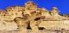
The above images may not be of the site on this page, but were taken nearby. They are loaded from Flickr so please click on them for image credits.
Click here to see more info for this site
Nearby sites
Click here to view sites on an interactive map of the areaKey: Red: member's photo, Blue: 3rd party photo, Yellow: other image, Green: no photo - please go there and take one, Grey: site destroyed
Download sites to:
KML (Google Earth)
GPX (GPS waypoints)
CSV (Garmin/Navman)
CSV (Excel)
To unlock full downloads you need to sign up as a Contributory Member. Otherwise downloads are limited to 50 sites.
Turn off the page maps and other distractions
Nearby sites listing. In the following links * = Image available
169m E 89° Cabezo del Plomo Chambered Cairn
28.9km NW 323° Totana* Ancient Village or Settlement
30.8km NW 312° Yacimiento Arqueológico La Bastida* Ancient Village or Settlement
36.5km WNW 292° Menhir La Tercia Standing Stone (Menhir)
45.6km NNW 337° Alto de Almoloya* Castro or Chafurdão
70.7km W 279° Cueva de los Letreros* Cave or Rock Shelter
72.3km NW 314° Cueva Negra* Natural Stone / Erratic / Other Natural Feature
75.3km WNW 292° La Cueva de Ambrosio* Cave or Rock Shelter
81.8km NE 44° La Fonteta* Ancient Village or Settlement
87.2km NNE 29° Els Pontets Aqueduct* Ancient Mine, Quarry or other Industry
87.9km NNE 28° Peña Negra* Ancient Village or Settlement
91.0km NE 36° L'Alcúdia* Ancient Village or Settlement
99.9km NW 318° Dolmen de Bagil* Burial Chamber or Dolmen
99.9km NW 318° Yacimiento Prehistórico de Bagil Ancient Village or Settlement
109.8km NNW 341° El Canajo Castro or Chafurdão
110.9km NNE 17° Cerro de los Moros Castro or Chafurdão
111.1km W 280° Necropolis de Tutugui* Ancient Village or Settlement
113.9km N 6° Abrigo del Canto de la Visera* Cave or Rock Shelter
116.6km N 8° Tobanilla Castro or Chafurdão
120.8km NNW 339° Minetada Caves* Cave or Rock Shelter
123.9km N 1° Petroglifos del Arabilejo Rock Art
124.0km N 1° Las Cazoletas del Arabilejo Ancient Village or Settlement
124.9km N 1° Cantos de la Visera Rock Art
125.1km N 1° La Cueva Horadada* Cave or Rock Shelter
126.3km W 267° Cerro Cepero Ancient Village or Settlement
View more nearby sites and additional images


 We would like to know more about this location. Please feel free to add a brief description and any relevant information in your own language.
 Wir möchten mehr über diese Stätte erfahren. Bitte zögern Sie nicht, eine kurze Beschreibung und relevante Informationen in Deutsch hinzuzufügen.
 Nous aimerions en savoir encore un peu sur les lieux. S'il vous plaît n'hesitez pas à ajouter une courte description et tous les renseignements pertinents dans votre propre langue.
 Quisieramos informarnos un poco más de las lugares. No dude en añadir una breve descripción y otros datos relevantes en su propio idioma.