<< Our Photo Pages >> Ebla Temple of Ishtar - Ancient Temple in Syria
Submitted by AlexHunger on Tuesday, 09 January 2007 Page Views: 9947
Neolithic and Bronze AgeSite Name: Ebla Temple of IshtarCountry: Syria
NOTE: This site is 6.675 km away from the location you searched for.
Type: Ancient Temple
Nearest Town: Aleppo Nearest Village: Tell Mardikh
Latitude: 35.798710N Longitude: 36.799140E
Condition:
| 5 | Perfect |
| 4 | Almost Perfect |
| 3 | Reasonable but with some damage |
| 2 | Ruined but still recognisable as an ancient site |
| 1 | Pretty much destroyed, possibly visible as crop marks |
| 0 | No data. |
| -1 | Completely destroyed |
| 5 | Superb |
| 4 | Good |
| 3 | Ordinary |
| 2 | Not Good |
| 1 | Awful |
| 0 | No data. |
| 5 | Can be driven to, probably with disabled access |
| 4 | Short walk on a footpath |
| 3 | Requiring a bit more of a walk |
| 2 | A long walk |
| 1 | In the middle of nowhere, a nightmare to find |
| 0 | No data. |
| 5 | co-ordinates taken by GPS or official recorded co-ordinates |
| 4 | co-ordinates scaled from a detailed map |
| 3 | co-ordinates scaled from a bad map |
| 2 | co-ordinates of the nearest village |
| 1 | co-ordinates of the nearest town |
| 0 | no data |
Internal Links:
External Links:
")
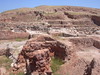
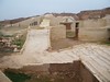
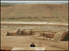
Besides the Sancturay of Ishtar amid the regular habitations, there is the proper Temple of Ishtar at the very top of the Tell.
You may be viewing yesterday's version of this page. To see the most up to date information please register for a free account.
")
Do not use the above information on other web sites or publications without permission of the contributor.
Nearby Images from Flickr
The above images may not be of the site on this page, but were taken nearby. They are loaded from Flickr so please click on them for image credits.
Click here to see more info for this site
Nearby sites
Click here to view sites on an interactive map of the areaKey: Red: member's photo, Blue: 3rd party photo, Yellow: other image, Green: no photo - please go there and take one, Grey: site destroyed
Download sites to:
KML (Google Earth)
GPX (GPS waypoints)
CSV (Garmin/Navman)
CSV (Excel)
To unlock full downloads you need to sign up as a Contributory Member. Otherwise downloads are limited to 50 sites.
Turn off the page maps and other distractions
Nearby sites listing. In the following links * = Image available
63m SW 232° Ebla.* Ancient Village or Settlement
162m WSW 241° Ebla Palace* Ancient Palace
11.3km N 0° Neirab* Ancient Village or Settlement
13.8km E 82° Ur-Schu Ancient Village or Settlement
38.6km WNW 294° Karkara Stone Fort or Dun
52.4km SW 218° Syrian tell* Ancient Village or Settlement
54.5km SW 221° Apamea* Ancient Village or Settlement
55.0km NE 35° Aleppo Museum* Museum
55.2km NE 36° Aleppo Tell* Ancient Village or Settlement
55.4km NE 36° Djade al-Mughara Ancient Village or Settlement
55.8km NE 34° Tel al-Abar 3 Ancient Village or Settlement
61.8km NW 323° Alalakh* Ancient Village or Settlement
62.7km NW 323° Tell Ta’yinat* Ancient Village or Settlement
66.7km N 5° Bit-Agusi Ancient Village or Settlement
72.3km NW 308° Antioch on the Orontes Ancient Village or Settlement
72.5km NW 310° Antakya Museum Museum
73.8km S 184° Hama.* Ancient Village or Settlement
74.1km S 183° Hama National Museum Museum
78.2km WNW 291° Al Mina Ancient Village or Settlement
78.8km N 5° Ain Dara* Ancient Temple
86.5km WNW 295° Seleukeia Temple of Zeus Ancient Temple
88.7km ENE 65° Tell Umm el-Marra Ancient Village or Settlement
92.9km ENE 62° Tal Om al-Mara Burial Chamber or Dolmen
94.0km WSW 257° Ugarit Temples* Ancient Temple
94.4km WSW 257° Ugarit Palace* Ancient Palace
View more nearby sites and additional images


 We would like to know more about this location. Please feel free to add a brief description and any relevant information in your own language.
 Wir möchten mehr über diese Stätte erfahren. Bitte zögern Sie nicht, eine kurze Beschreibung und relevante Informationen in Deutsch hinzuzufügen.
 Nous aimerions en savoir encore un peu sur les lieux. S'il vous plaît n'hesitez pas à ajouter une courte description et tous les renseignements pertinents dans votre propre langue.
 Quisieramos informarnos un poco más de las lugares. No dude en añadir una breve descripción y otros datos relevantes en su propio idioma.