<< Our Photo Pages >> Inscription Canyon - Rock Art in United States in The Southwest
Submitted by mfrincu on Sunday, 19 April 2015 Page Views: 3404
Rock ArtSite Name: Inscription Canyon Alternative Name: Black Mountain Rock ArtCountry: United States
NOTE: This site is 35.395 km away from the location you searched for.
Region: The Southwest Type: Rock Art
Nearest Town: Barstow Nearest Village: Hinkley
Latitude: 35.197869N Longitude: 117.193823W
Condition:
| 5 | Perfect |
| 4 | Almost Perfect |
| 3 | Reasonable but with some damage |
| 2 | Ruined but still recognisable as an ancient site |
| 1 | Pretty much destroyed, possibly visible as crop marks |
| 0 | No data. |
| -1 | Completely destroyed |
| 5 | Superb |
| 4 | Good |
| 3 | Ordinary |
| 2 | Not Good |
| 1 | Awful |
| 0 | No data. |
| 5 | Can be driven to, probably with disabled access |
| 4 | Short walk on a footpath |
| 3 | Requiring a bit more of a walk |
| 2 | A long walk |
| 1 | In the middle of nowhere, a nightmare to find |
| 0 | No data. |
| 5 | co-ordinates taken by GPS or official recorded co-ordinates |
| 4 | co-ordinates scaled from a detailed map |
| 3 | co-ordinates scaled from a bad map |
| 2 | co-ordinates of the nearest village |
| 1 | co-ordinates of the nearest town |
| 0 | no data |
Internal Links:
External Links:
I have visited· I would like to visit
mfrincu visited on 26th Mar 2014 - their rating: Cond: 3 Amb: 4 Access: 2 You can easily get lost in all the dirt roads but once you find it, the collection of petroglyphs is amazing!
")
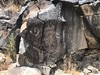
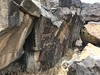
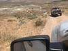
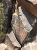
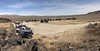
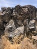
The site is located in the Black Mountains NW of the city of Barstow. Access requires 4WD and a map because of the numerous dirt roads in the area. Entry to the site is marked. There are hundreds of petroglyphs engraved in an ancient canyon made of volcanic rock. Most of them are abstract (circles, lines, squares, crosses, spirals) with some being anthropomorphic and depicting animals. Interestingly, there are few spirals engraved on rocks which may indicate a solar connection to solstices and equinoxes, however studies have not been performed on those dates to see whether or not we see sun daggers on them.
You may be viewing yesterday's version of this page. To see the most up to date information please register for a free account.
")
")
Do not use the above information on other web sites or publications without permission of the contributor.
Nearby Images from Flickr
The above images may not be of the site on this page, but were taken nearby. They are loaded from Flickr so please click on them for image credits.
Click here to see more info for this site
Nearby sites
Click here to view sites on an interactive map of the areaKey: Red: member's photo, Blue: 3rd party photo, Yellow: other image, Green: no photo - please go there and take one, Grey: site destroyed
Download sites to:
KML (Google Earth)
GPX (GPS waypoints)
CSV (Garmin/Navman)
CSV (Excel)
To unlock full downloads you need to sign up as a Contributory Member. Otherwise downloads are limited to 50 sites.
Turn off the page maps and other distractions
Nearby sites listing. In the following links * = Image available
96.3km NNW 337° Coso Petroglyphs* Rock Art
103.9km W 267° Tomo Kahni* Rock Art
120.1km E 89° 17 Mile Point* Rock Art
129.9km SW 232° Tataviam Pictograph Site* Rock Art
153.3km SE 137° Archaeology and Paleontology Curation Center Museum
157.9km S 175° Hemet Maze Stone* Rock Art
161.5km SE 144° Brunette Lady* Rock Art
161.5km SE 143° Barker Dam Trail* Rock Art
162.0km SE 143° Red lady* Rock Art
164.5km E 96° Hole-in-the-Wall* Rock Art
165.1km SW 221° Levitated Mass* Modern Stone Circle etc
165.9km NW 304° Painted Rock at Tule River Rock Art
168.4km NNW 338° Swansea petroglyph site* Rock Art
169.9km E 95° Tortoise Shell Mountain* Rock Art
182.6km W 263° Wind Wolves Preserve* Rock Art
183.2km SSW 206° Bolsa Chica Mesa* Ancient Village or Settlement
188.7km SSE 165° Anza Fertility Site* Natural Stone / Erratic / Other Natural Feature
190.6km ENE 56° Lost Creek* Rock Art
208.2km ENE 67° Sloan Petroglyph Site* Rock Art
227.8km E 88° Grapevine Canyon* Rock Art
235.3km S 175° San Diego Archaeological Centre* Museum
236.4km ENE 60° Gypsum Cave Cave or Rock Shelter
242.4km W 269° Painted Rock, Carrizo Plain* Rock Art
244.3km WSW 250° Burton Mound* Artificial Mound
244.8km SE 135° Corn Springs* Rock Art
View more nearby sites and additional images


 We would like to know more about this location. Please feel free to add a brief description and any relevant information in your own language.
 Wir möchten mehr über diese Stätte erfahren. Bitte zögern Sie nicht, eine kurze Beschreibung und relevante Informationen in Deutsch hinzuzufügen.
 Nous aimerions en savoir encore un peu sur les lieux. S'il vous plaît n'hesitez pas à ajouter une courte description et tous les renseignements pertinents dans votre propre langue.
 Quisieramos informarnos un poco más de las lugares. No dude en añadir una breve descripción y otros datos relevantes en su propio idioma.