<< Our Photo Pages >> Avicenna Mausoleum and Museum - Museum in Iran
Submitted by DrewParsons on Monday, 28 April 2014 Page Views: 3265
MuseumsSite Name: Avicenna Mausoleum and Museum Alternative Name: Buali Sina TombCountry: Iran
NOTE: This site is 134.564 km away from the location you searched for.
Type: Museum
Nearest Town: Hamadan
Latitude: 34.791510N Longitude: 48.513140E
Condition:
| 5 | Perfect |
| 4 | Almost Perfect |
| 3 | Reasonable but with some damage |
| 2 | Ruined but still recognisable as an ancient site |
| 1 | Pretty much destroyed, possibly visible as crop marks |
| 0 | No data. |
| -1 | Completely destroyed |
| 5 | Superb |
| 4 | Good |
| 3 | Ordinary |
| 2 | Not Good |
| 1 | Awful |
| 0 | No data. |
| 5 | Can be driven to, probably with disabled access |
| 4 | Short walk on a footpath |
| 3 | Requiring a bit more of a walk |
| 2 | A long walk |
| 1 | In the middle of nowhere, a nightmare to find |
| 0 | No data. |
| 5 | co-ordinates taken by GPS or official recorded co-ordinates |
| 4 | co-ordinates scaled from a detailed map |
| 3 | co-ordinates scaled from a bad map |
| 2 | co-ordinates of the nearest village |
| 1 | co-ordinates of the nearest town |
| 0 | no data |
Internal Links:
External Links:
I have visited· I would like to visit
DrewParsons has visited here
")
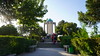
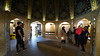
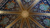
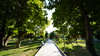
Avicenna was a Persian polymath (980 - 1037AD) most famous in the west for his writings on medical science. His mausoleum in Buali Sina Square, central Hamadan also has a small museum with displays of ancient artifacts from the region including the 3rd millennium tripod vase shown in the photo below.
You may be viewing yesterday's version of this page. To see the most up to date information please register for a free account.
")
")
Do not use the above information on other web sites or publications without permission of the contributor.
Nearby Images from Flickr

The above images may not be of the site on this page, but were taken nearby. They are loaded from Flickr so please click on them for image credits.
Click here to see more info for this site
Nearby sites
Click here to view sites on an interactive map of the areaKey: Red: member's photo, Blue: 3rd party photo, Yellow: other image, Green: no photo - please go there and take one, Grey: site destroyed
Download sites to:
KML (Google Earth)
GPX (GPS waypoints)
CSV (Garmin/Navman)
CSV (Excel)
To unlock full downloads you need to sign up as a Contributory Member. Otherwise downloads are limited to 50 sites.
Turn off the page maps and other distractions
Nearby sites listing. In the following links * = Image available
1.6km NNE 13° Ecbatana Ancient Village or Settlement
7.6km WSW 245° Ganjnameh* Carving
50.7km SW 233° Godin Tepe* Ancient Village or Settlement
60.1km WSW 238° Anahita Temple* Ancient Temple
81.9km WSW 246° Sahneh Rock Cut Tombs* Rock Cut Tomb
88.9km WSW 241° Charkhab Palace Ancient Palace
100.9km SSW 212° Bābā Jān Tepe* Ancient Village or Settlement
108.2km WSW 246° Bisitun* Ancient Village or Settlement
134.2km WSW 251° Taq-e Bostan Reliefs* Carving
146.2km S 186° Falak-ol-Aflak Fortress* Museum
148.7km WNW 282° Rabat Tepe Ancient Village or Settlement
221.0km N 356° Chehr-Abad Salt Mine Ancient Mine, Quarry or other Industry
245.3km ENE 66° Arastu Tepe Ancient Village or Settlement
278.7km ESE 109° Kashan National Museum* Museum
280.6km ESE 108° Tepe Sialk* Ancient Temple
282.4km ESE 104° Vigol Ancient Village or Settlement
285.3km S 179° Chogha Mish* Ancient Village or Settlement
290.0km S 185° Susa (Iran)* Ancient Palace
302.0km S 183° Haft Tepe* Ancient Temple
309.4km S 180° Chogha Zanbil* Ancient Temple
334.6km WSW 253° Eshnunna Ancient Village or Settlement
366.6km WNW 290° Satu Qala (Idu)* Ancient Village or Settlement
367.3km NW 313° Hajji Firuz Tepe Ancient Village or Settlement
369.1km NW 313° Hasanlu Tepe Ancient Village or Settlement
369.8km SE 129° Marabin Fire Temple* Ancient Temple
View more nearby sites and additional images


 We would like to know more about this location. Please feel free to add a brief description and any relevant information in your own language.
 Wir möchten mehr über diese Stätte erfahren. Bitte zögern Sie nicht, eine kurze Beschreibung und relevante Informationen in Deutsch hinzuzufügen.
 Nous aimerions en savoir encore un peu sur les lieux. S'il vous plaît n'hesitez pas à ajouter une courte description et tous les renseignements pertinents dans votre propre langue.
 Quisieramos informarnos un poco más de las lugares. No dude en añadir una breve descripción y otros datos relevantes en su propio idioma.