<< Other Photo Pages >> Etowah Mounds - Mound C - Artificial Mound in United States in The South
Submitted by woode on Monday, 25 July 2005 Page Views: 8526
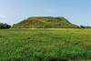
Pre-ColumbianSite Name: Etowah Mounds - Mound CCountry: United States
NOTE: This site is 55.473 km away from the location you searched for.
Region: The South Type: Artificial Mound
Nearest Town: Cartersville
Latitude: 34.124583N Longitude: 84.806528W
Condition:
| 5 | Perfect |
| 4 | Almost Perfect |
| 3 | Reasonable but with some damage |
| 2 | Ruined but still recognisable as an ancient site |
| 1 | Pretty much destroyed, possibly visible as crop marks |
| 0 | No data. |
| -1 | Completely destroyed |
| 5 | Superb |
| 4 | Good |
| 3 | Ordinary |
| 2 | Not Good |
| 1 | Awful |
| 0 | No data. |
| 5 | Can be driven to, probably with disabled access |
| 4 | Short walk on a footpath |
| 3 | Requiring a bit more of a walk |
| 2 | A long walk |
| 1 | In the middle of nowhere, a nightmare to find |
| 0 | No data. |
| 5 | co-ordinates taken by GPS or official recorded co-ordinates |
| 4 | co-ordinates scaled from a detailed map |
| 3 | co-ordinates scaled from a bad map |
| 2 | co-ordinates of the nearest village |
| 1 | co-ordinates of the nearest town |
| 0 | no data |
Internal Links:
External Links:
")
Mound C is a burial mound that contained about 350 burials, with grave goods including shell gorgets in an artistic style not unlike that of Central America and Mexico. The most notable find from Mound C is a pair of painted marble human effigy statues, a male and a female.
An image of a shell gorget can be seen at the University of Georgia Anthropology Photo Collection.
Photos of the effigy statues, and photos and drawings of other Etowah artefacts can be seen at Lost Worlds: Georgia: Etowah Mounds.
See the entry for Mound A for more information.
You may be viewing yesterday's version of this page. To see the most up to date information please register for a free account.
")
")
Do not use the above information on other web sites or publications without permission of the contributor.
Nearby Images from Flickr


The above images may not be of the site on this page, but were taken nearby. They are loaded from Flickr so please click on them for image credits.
Click here to see more info for this site
Nearby sites
Click here to view sites on an interactive map of the areaKey: Red: member's photo, Blue: 3rd party photo, Yellow: other image, Green: no photo - please go there and take one, Grey: site destroyed
Download sites to:
KML (Google Earth)
GPX (GPS waypoints)
CSV (Garmin/Navman)
CSV (Excel)
To unlock full downloads you need to sign up as a Contributory Member. Otherwise downloads are limited to 50 sites.
Turn off the page maps and other distractions
Nearby sites listing. In the following links * = Image available
101m WNW 297° Etowah Mounds - Mound A* Artificial Mound
139m SW 236° Etowah Mounds - Mound B* Artificial Mound
329m NNW 344° Etowah Mounds - Ditch and Palisade* Misc. Earthwork
380m N 354° Etowah Mounds Museum* Museum
2.5km NNW 332° Arborrigg* Modern Stone Circle etc
31.9km NE 47° Funk Heritage Center* Museum
71.4km N 8° Fort Mountain Stone Enclosure* Cairn
73.2km W 281° Coker Ford Site* Ancient Village or Settlement
91.2km WSW 247° Shelton Stone Mound Complex* Cairn
98.4km W 279° Collinsville Indian Mound* Artificial Mound
100.4km WSW 241° Choccolocco Stone Standing Stone (Menhir)
107.2km WSW 237° Oxford Stone Mound* Artificial Mound
107.9km WSW 238° Choccolocco Creek Mounds* Artificial Mound
110.5km SW 215° Rother L. Harris Reservoir Stone Standing Stone (Menhir)
111.0km SW 234° Talladega National Forest Stone 1Ta756 Standing Stone (Menhir)
115.1km NNW 339° Roxbury Indian Mound* Artificial Mound
115.4km NE 55° Hickorynut Track Rock* Rock Art
118.3km ENE 58° Nacoochee* Barrow Cemetery
120.0km NE 45° Track Rock* Rock Art
120.1km NE 45° Track Rock Gap Archaeological Area* Stone Row / Alignment
120.5km ENE 59° Kenimer* Artificial Mound
121.1km ENE 59° Sautee-Nacoochee earthwork Ancient Village or Settlement
122.0km N 356° Candies Creek Village Archaeological Preserve* Ancient Village or Settlement
132.1km E 94° Sandy Creek terrace complex* Ancient Village or Settlement
132.1km NW 316° Russell Cave Mound* Artificial Mound
View more nearby sites and additional images


 We would like to know more about this location. Please feel free to add a brief description and any relevant information in your own language.
 Wir möchten mehr über diese Stätte erfahren. Bitte zögern Sie nicht, eine kurze Beschreibung und relevante Informationen in Deutsch hinzuzufügen.
 Nous aimerions en savoir encore un peu sur les lieux. S'il vous plaît n'hesitez pas à ajouter une courte description et tous les renseignements pertinents dans votre propre langue.
 Quisieramos informarnos un poco más de las lugares. No dude en añadir una breve descripción y otros datos relevantes en su propio idioma.