<< Our Photo Pages >> QanaWat Nympheum - Holy Well or Sacred Spring in Syria
Submitted by AlexHunger on Wednesday, 10 January 2007 Page Views: 6131
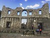
Springs and Holy WellsSite Name: QanaWat NympheumCountry: Syria
NOTE: This site is 20.187 km away from the location you searched for.
Type: Holy Well or Sacred Spring
Nearest Town: Damascus Nearest Village: Qanawat
Latitude: 32.754269N Longitude: 36.618262E
Condition:
| 5 | Perfect |
| 4 | Almost Perfect |
| 3 | Reasonable but with some damage |
| 2 | Ruined but still recognisable as an ancient site |
| 1 | Pretty much destroyed, possibly visible as crop marks |
| 0 | No data. |
| -1 | Completely destroyed |
| 5 | Superb |
| 4 | Good |
| 3 | Ordinary |
| 2 | Not Good |
| 1 | Awful |
| 0 | No data. |
| 5 | Can be driven to, probably with disabled access |
| 4 | Short walk on a footpath |
| 3 | Requiring a bit more of a walk |
| 2 | A long walk |
| 1 | In the middle of nowhere, a nightmare to find |
| 0 | No data. |
| 5 | co-ordinates taken by GPS or official recorded co-ordinates |
| 4 | co-ordinates scaled from a detailed map |
| 3 | co-ordinates scaled from a bad map |
| 2 | co-ordinates of the nearest village |
| 1 | co-ordinates of the nearest town |
| 0 | no data |
Internal Links:
External Links:
")
Ancient Holy well, built over by the Romans.
The path down from the road is quite treacherous, so a way around needs to be found. Also the water doesn't look clean. About 1170 Meters altitude.
You may be viewing yesterday's version of this page. To see the most up to date information please register for a free account.
Do not use the above information on other web sites or publications without permission of the contributor.
Nearby Images from Flickr


The above images may not be of the site on this page, but were taken nearby. They are loaded from Flickr so please click on them for image credits.
Click here to see more info for this site
Nearby sites
Click here to view sites on an interactive map of the areaKey: Red: member's photo, Blue: 3rd party photo, Yellow: other image, Green: no photo - please go there and take one, Grey: site destroyed
Download sites to:
KML (Google Earth)
GPX (GPS waypoints)
CSV (Garmin/Navman)
CSV (Excel)
To unlock full downloads you need to sign up as a Contributory Member. Otherwise downloads are limited to 50 sites.
Turn off the page maps and other distractions
Nearby sites listing. In the following links * = Image available
498m SSW 197° QanaWat Temple of Helios* Ancient Temple
29.3km SSW 206° Bosra* Ancient Village or Settlement
50.0km WSW 253° Tal al-Ashari Barrow Cemetery
53.0km SSW 206° Umm el-Jimal* Ancient Village or Settlement
56.5km SSE 159° Qasr Deir Al-Kahf* Stone Fort or Dun
58.2km NNW 341° El-Leja Desert Kite* Misc. Earthwork
58.9km SE 142° Jawa* Ancient Village or Settlement
72.6km N 355° Tell Aswad Ancient Village or Settlement
75.2km WSW 247° Jdeta* Burial Chamber or Dolmen
75.3km WSW 254° Irbid* Ancient Village or Settlement
76.9km WNW 294° Dubbah Breika Ancient Village or Settlement
77.6km W 281° Dolmen field near Natur on the Golan Heights* Barrow Cemetery
78.3km WNW 283° Rujm el-Hiri* Stone Circle
78.4km SSW 200° Qasr al-Hallabat* Stone Fort or Dun
78.8km SE 128° Khirbet al-Ja’bariya* Hillfort
79.5km WSW 255° Rasun (Jordan)* Burial Chamber or Dolmen
82.9km WNW 282° Gamla Dolmen field* Burial Chamber or Dolmen
83.1km WNW 282° The ancient city of Gamla* Ancient Village or Settlement
86.2km SW 232° Jerash* Ancient Village or Settlement
88.7km W 263° Gadara* Ancient Village or Settlement
89.4km W 272° Wadi Ein Gev Ancient Village or Settlement
89.4km W 272° NEG II Prehistoric Village* Ancient Village or Settlement
89.7km W 272° Sussita* Ancient Village or Settlement
89.7km NNW 340° Damascus National Museum* Museum
90.5km NNW 340° Tal al-Humira Ancient Village or Settlement
View more nearby sites and additional images


 We would like to know more about this location. Please feel free to add a brief description and any relevant information in your own language.
 Wir möchten mehr über diese Stätte erfahren. Bitte zögern Sie nicht, eine kurze Beschreibung und relevante Informationen in Deutsch hinzuzufügen.
 Nous aimerions en savoir encore un peu sur les lieux. S'il vous plaît n'hesitez pas à ajouter une courte description et tous les renseignements pertinents dans votre propre langue.
 Quisieramos informarnos un poco más de las lugares. No dude en añadir una breve descripción y otros datos relevantes en su propio idioma.