<< Other Photo Pages >> Graveline Mound Site - Artificial Mound in United States in The South
Submitted by AKFisher on Friday, 25 August 2023 Page Views: 2394
Pre-ColumbianSite Name: Graveline Mound Site Alternative Name: Graveline Mounds, 22Ja503Country: United States Region: The South Type: Artificial Mound
Nearest Town: Gautier, MS
Latitude: 30.363520N Longitude: 88.6596W
Condition:
| 5 | Perfect |
| 4 | Almost Perfect |
| 3 | Reasonable but with some damage |
| 2 | Ruined but still recognisable as an ancient site |
| 1 | Pretty much destroyed, possibly visible as crop marks |
| 0 | No data. |
| -1 | Completely destroyed |
| 5 | Superb |
| 4 | Good |
| 3 | Ordinary |
| 2 | Not Good |
| 1 | Awful |
| 0 | No data. |
| 5 | Can be driven to, probably with disabled access |
| 4 | Short walk on a footpath |
| 3 | Requiring a bit more of a walk |
| 2 | A long walk |
| 1 | In the middle of nowhere, a nightmare to find |
| 0 | No data. |
| 5 | co-ordinates taken by GPS or official recorded co-ordinates |
| 4 | co-ordinates scaled from a detailed map |
| 3 | co-ordinates scaled from a bad map |
| 2 | co-ordinates of the nearest village |
| 1 | co-ordinates of the nearest town |
| 0 | no data |
Internal Links:
External Links:

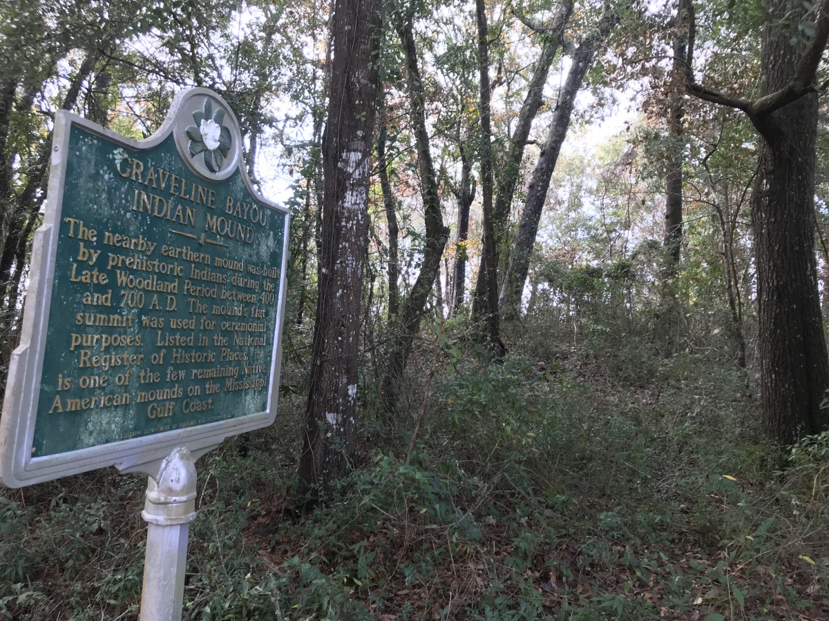
Threatened by destruction from encroaching development, the Graveline Mound site was acquired by The Archaeological Conservancy in 2000. The site is located in a residential subdivision of the City of Gautier on a small, undeveloped lot that is surrounded by both roadways and homes. Positioned approximately 150 m north of Mississippi Sound on the Gulf of Mexico, the mound rests on a flat terrace formation dating to the Pleistocene. Several small unnamed bayous enter the Gulf just to the east and to the west of the mound, with the mouth of the larger Graveline Bayou being located about 375 m to the west of the site. Thus, the site is readily accessible via watercraft and is located within close proximity to abundant aquatic resources.
Though the original contours of Graveline Mound have been affected by the processes of erosion over the years, it is clear that the initial earthen structure was rectangular in shape with a flat summit. The mound currently stands 1.65 m in height, with a large summit measuring approximately 20 m in length by 15 m in width. Roughly oriented along a northeast-southwest line, the long axis of the mound measures 30 m in length, while the shorter axis measures 25 m. An eroded, yet visible, ramp extending from the mound summit is located on the southern flank of the mound. The degree to which erosion has modified the original size of the mound currently is unknown, though it is almost certain that the overall height of the mound has been reduced since its initial construction. Unfortunately, looting also has contributed to the modification of the original shape and size of the mound, especially along the northern mound flank where eroded pits are as wide as five meters. Despite such damage, the mound remains in good condition and holds the potential to reveal extremely valuable data on the woodland period occupation along the Mississippi Gulf Coast.
Indeed, Graveline Mound is the only known example of a Woodland period platform mound in this portion of the region. Our knowledge of Woodland period occupation in the eastern portion of the Mississippi Sound region is extremely limited, due, in part, to a dearth of intact, non-disturbed deposits. Unfortunately, residential development, erosion, and storm and hurricane activity all have contributed to the substantial and ongoing destruction of many contemporaneous sites located on or near the coastline. Notably, however, at least five smaller, conical mounds are known within a 500 m radius of the Graveline Mound. Because these mounds are located on private property and have not yet been investigated archaeologically, little is known about their possible relationship, if any, with the Graveline Mound. If coeval with the Graveline site, such a grouping would represent the largest known concentration of prehistoric mounds along the Gulf Coast strand between northwestern Florida and Louisiana.
Source: Mississippi Archaeology Trails (.gov site - see link below).
Further reading and information:
MS Archaeology Trails
trails.mdah.ms.gov/ct/graveline.htm<2>
ResearchGate
http://www.researchgate.net/figure/Graveline-Mound-site-map-illustrating-test-units-1-2-m-Black-units-represent-the_fig2_268823493<4>
Directions:
From Gautier, MS via Graveline Rd., 4.1 mi.
You may be viewing yesterday's version of this page. To see the most up to date information please register for a free account.

Do not use the above information on other web sites or publications without permission of the contributor.
Nearby Images from Flickr


The above images may not be of the site on this page, but were taken nearby. They are loaded from Flickr so please click on them for image credits.
Click here to see more info for this site
Nearby sites
Click here to view sites on an interactive map of the areaKey: Red: member's photo, Blue: 3rd party photo, Yellow: other image, Green: no photo - please go there and take one, Grey: site destroyed
Download sites to:
KML (Google Earth)
GPX (GPS waypoints)
CSV (Garmin/Navman)
CSV (Excel)
To unlock full downloads you need to sign up as a Contributory Member. Otherwise downloads are limited to 50 sites.
Turn off the page maps and other distractions
Nearby sites listing. In the following links * = Image available
54.3km ESE 102° Dauphin Island Shell Mound Park* Ancient Mine, Quarry or other Industry
80.7km ENE 63° Fuller Shell Mound Site* Artificial Mound
82.7km ENE 59° Blakeley Indian Mounds* Artificial Mound
97.7km E 96° Gulf State Park Shell and Sand Mounds* Artificial Mound
99.5km NE 44° Bottle Creek* Ancient Village or Settlement
104.9km E 92° Bamahenge* Modern Stone Circle etc
142.2km SW 230° Bayou Grande Cheniere Mounds* Artificial Mound
151.8km NE 37° Mauvilla Ancient Village or Settlement
196.9km E 88° Fort Walton Mound* Artificial Mound
242.0km W 272° Louisiana State University Campus Mounds Artificial Mound
263.1km NE 34° Old Cahawba Archaeological Park* Misc. Earthwork
268.0km NNW 330° Boyd Mounds* Barrow Cemetery
279.7km NW 311° Mangum Mound* Artificial Mound
280.0km WNW 289° Lessley Mound* Artificial Mound
280.6km NNW 327° Pocahontas Mound A* Artificial Mound
284.3km WNW 301° Emerald Mound, Mississippi* Artificial Mound
285.7km N 355° Nanih Waiya Mound* Artificial Mound
286.3km WNW 288° Smith Creek Mounds* Artificial Mound
286.7km NW 309° Bayou Pierre Mounds* Artificial Mound
289.2km WNW 299° Foster Mounds* Artificial Mound
289.2km WNW 299° Fosters Ancient Village or Settlement
289.7km WNW 297° Grand Village of Natchez Indians* Ancient Village or Settlement
289.9km WNW 298° Natchez Trace* Ancient Trackway
293.4km NW 308° Windsor Mounds* Artificial Mound
296.0km WNW 301° Anna Mound Complex* Artificial Mound
View more nearby sites and additional images


 We would like to know more about this location. Please feel free to add a brief description and any relevant information in your own language.
 Wir möchten mehr über diese Stätte erfahren. Bitte zögern Sie nicht, eine kurze Beschreibung und relevante Informationen in Deutsch hinzuzufügen.
 Nous aimerions en savoir encore un peu sur les lieux. S'il vous plaît n'hesitez pas à ajouter une courte description et tous les renseignements pertinents dans votre propre langue.
 Quisieramos informarnos un poco más de las lugares. No dude en añadir una breve descripción y otros datos relevantes en su propio idioma.