<< Text Pages >> Xihuacan - Pyramid / Mastaba in Mexico in Mexico Other
Submitted by Godzilla1 on Friday, 26 October 2018 Page Views: 4276
Multi-periodSite Name: Xihuacan Alternative Name: Soledad de Maciel Archeological ZoneCountry: Mexico
NOTE: This site is 103.544 km away from the location you searched for.
Region: Mexico Other Type: Pyramid / Mastaba
Nearest Town: Patatlan Nearest Village: Soledad de Maciel
Latitude: 17.526389N Longitude: 101.333333W
Condition:
| 5 | Perfect |
| 4 | Almost Perfect |
| 3 | Reasonable but with some damage |
| 2 | Ruined but still recognisable as an ancient site |
| 1 | Pretty much destroyed, possibly visible as crop marks |
| 0 | No data. |
| -1 | Completely destroyed |
| 5 | Superb |
| 4 | Good |
| 3 | Ordinary |
| 2 | Not Good |
| 1 | Awful |
| 0 | No data. |
| 5 | Can be driven to, probably with disabled access |
| 4 | Short walk on a footpath |
| 3 | Requiring a bit more of a walk |
| 2 | A long walk |
| 1 | In the middle of nowhere, a nightmare to find |
| 0 | No data. |
| 5 | co-ordinates taken by GPS or official recorded co-ordinates |
| 4 | co-ordinates scaled from a detailed map |
| 3 | co-ordinates scaled from a bad map |
| 2 | co-ordinates of the nearest village |
| 1 | co-ordinates of the nearest town |
| 0 | no data |
Internal Links:
External Links:
Pyramid / Mastaba in Mexico Other
Pre-Olmec sacred site with mud brick pyramid within 27 km Zihuatanejo. Xihuacan is Nuhua for "place of Turquoise owners", or possibly "those who control the calendar". Site occupied from approx. 1500 BCE, peak at 450 - 1100 CE. Collapse approx. 1350 CE due to natural catastrophe or possible conflict.
Very nice museum, access to pyramid, stelae, ritual spaces and ball court.
Please see www.lachole.com for site information and artifact photos.
You may be viewing yesterday's version of this page. To see the most up to date information please register for a free account.
Do not use the above information on other web sites or publications without permission of the contributor.
Nearby Images from Flickr
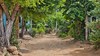
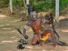

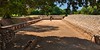

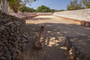
The above images may not be of the site on this page, but were taken nearby. They are loaded from Flickr so please click on them for image credits.
Click here to see more info for this site
Nearby sites
Click here to view sites on an interactive map of the areaKey: Red: member's photo, Blue: 3rd party photo, Yellow: other image, Green: no photo - please go there and take one, Grey: site destroyed
Download sites to:
KML (Google Earth)
GPX (GPS waypoints)
CSV (Garmin/Navman)
CSV (Excel)
To unlock full downloads you need to sign up as a Contributory Member. Otherwise downloads are limited to 50 sites.
Turn off the page maps and other distractions
Nearby sites listing. In the following links * = Image available
203.5km NNW 346° Tipitarillo Yacata Pyramid / Mastaba
225.0km ENE 65° Xihuatoxtla Cave or Rock Shelter
225.7km NNW 346° Tingambato* Ancient Village or Settlement
228.9km N 356° Sacapu Angamuco Ancient Village or Settlement
230.2km N 352° Ihuatzio* Ancient Village or Settlement
234.5km E 92° Grottos of Juxtlahuaca Cave or Rock Shelter
234.6km N 354° Tzintzuntzan* Ancient Village or Settlement
236.3km NNW 336° Purepecha Digs Ancient Village or Settlement
238.5km N 355° Purépecha Proto Urban Site Ancient Village or Settlement
241.9km NE 43° Nevado de Toluca Natural Stone / Erratic / Other Natural Feature
254.1km NE 46° Teotenango* Ancient Temple
257.9km ENE 56° Xochicalco* Ancient Village or Settlement
272.2km NE 55° Cuernavaca - Piramide de Teopanzolco* Pyramid / Mastaba
274.5km N 1° Huandacareo Ancient Village or Settlement
287.1km NE 55° Tepoztlan* Ancient Village or Settlement
299.6km ENE 64° Chalcatzingo* Rock Art
300.9km NE 49° Cuicuilco* Pyramid / Mastaba
301.0km NE 49° Tlalpan Ancient Village or Settlement
309.7km NE 47° Museo Nacional de Antropología* Museum
313.4km NNE 29° Huamango Ancient Village or Settlement
314.6km NE 47° Tenochtitlan - Templo Mayor* Ancient Temple
315.3km NE 47° Tlatelolco* Ancient Village or Settlement
316.1km NW 307° Colima - Eastern Shaft Tomb* Barrow Cemetery
319.1km NE 45° Tenayuca* Pyramid / Mastaba
320.3km NE 45° Acatitlan* Ancient Temple
View more nearby sites and additional images


 We would like to know more about this location. Please feel free to add a brief description and any relevant information in your own language.
 Wir möchten mehr über diese Stätte erfahren. Bitte zögern Sie nicht, eine kurze Beschreibung und relevante Informationen in Deutsch hinzuzufügen.
 Nous aimerions en savoir encore un peu sur les lieux. S'il vous plaît n'hesitez pas à ajouter une courte description et tous les renseignements pertinents dans votre propre langue.
 Quisieramos informarnos un poco más de las lugares. No dude en añadir una breve descripción y otros datos relevantes en su propio idioma.