<< Text Pages >> Pungo Andongo - Rock Art in Angola
Submitted by KaiHofmann on Tuesday, 29 January 2013 Page Views: 2031
Rock ArtSite Name: Pungo AndongoCountry: Angola
NOTE: This site is 83.328 km away from the location you searched for.
Type: Rock Art
Nearest Town: Malanje
Latitude: 9.667372S Longitude: 15.588566E
Condition:
| 5 | Perfect |
| 4 | Almost Perfect |
| 3 | Reasonable but with some damage |
| 2 | Ruined but still recognisable as an ancient site |
| 1 | Pretty much destroyed, possibly visible as crop marks |
| 0 | No data. |
| -1 | Completely destroyed |
| 5 | Superb |
| 4 | Good |
| 3 | Ordinary |
| 2 | Not Good |
| 1 | Awful |
| 0 | No data. |
| 5 | Can be driven to, probably with disabled access |
| 4 | Short walk on a footpath |
| 3 | Requiring a bit more of a walk |
| 2 | A long walk |
| 1 | In the middle of nowhere, a nightmare to find |
| 0 | No data. |
| 5 | co-ordinates taken by GPS or official recorded co-ordinates |
| 4 | co-ordinates scaled from a detailed map |
| 3 | co-ordinates scaled from a bad map |
| 2 | co-ordinates of the nearest village |
| 1 | co-ordinates of the nearest town |
| 0 | no data |
Be the first person to rate this site - see the 'Contribute!' box in the right hand menu.
Internal Links:
External Links:
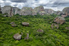
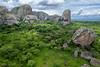
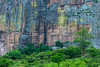
Strange rock formation called Pedras Negras. In between this large rocks close to a small river lies a site which shows ten human footprint petroglyphs.
You may be viewing yesterday's version of this page. To see the most up to date information please register for a free account.
Do not use the above information on other web sites or publications without permission of the contributor.
Nearby Images from Flickr


The above images may not be of the site on this page, but were taken nearby. They are loaded from Flickr so please click on them for image credits.
Click here to see more info for this site
Nearby sites
Click here to view sites on an interactive map of the areaKey: Red: member's photo, Blue: 3rd party photo, Yellow: other image, Green: no photo - please go there and take one, Grey: site destroyed
Download sites to:
KML (Google Earth)
GPX (GPS waypoints)
CSV (Garmin/Navman)
CSV (Excel)
To unlock full downloads you need to sign up as a Contributory Member. Otherwise downloads are limited to 50 sites.
Turn off the page maps and other distractions
Nearby sites listing. In the following links * = Image available
67.5km SW 233° Pedra Quissongo Rock Art
270.3km SSE 159° Moma Rock Art
493.5km N 351° Grottes de Dimba et Ngoyo Cave or Rock Shelter
520.0km SSW 198° Quilengues Gravures Rupestres Rock Art
557.6km SSW 207° Txipopilu Petroglyphs Rock Art
756.8km SSW 203° Tshitundo Hulo Rock Art
834.2km SSW 197° Pinturas Rupestres do Monte Negro Rock Art
1077.6km ESE 105° Nyambwezu Rock Shelter Rock Art
1191.7km S 181° Vingerklip* Natural Stone / Erratic / Other Natural Feature
1196.2km S 181° Omburo Ost* Rock Art
1208.7km SSE 147° Tsodilo Hills* Rock Art
1222.2km S 186° Twyfelfontein* Rock Art
1222.4km S 186° Twyfelfontein* Stone Circle
1276.3km S 184° The White Lady Group* Rock Art
1347.7km S 176° Oropoko* Rock Art
1348.0km S 178° Paula's Cave Rock Art
1349.1km S 180° Phillipp's Cave Rock Art
1352.6km S 182° Bushman Paradise* Rock Art
1395.8km SE 125° Sikaunda petroglyphs Rock Art
1502.6km S 178° Rooisand Rock Painting* Rock Art
1533.3km S 181° Mirabib* Natural Stone / Erratic / Other Natural Feature
1587.6km SE 141° Makgadikgadi* Ancient Village or Settlement
1715.4km E 93° Mwela rock paintings Rock Art
1827.1km SE 133° Bambata Cave* Cave or Rock Shelter
1835.2km SE 132° World's View Matobo National Park* Natural Stone / Erratic / Other Natural Feature
View more nearby sites and additional images


 We would like to know more about this location. Please feel free to add a brief description and any relevant information in your own language.
 Wir möchten mehr über diese Stätte erfahren. Bitte zögern Sie nicht, eine kurze Beschreibung und relevante Informationen in Deutsch hinzuzufügen.
 Nous aimerions en savoir encore un peu sur les lieux. S'il vous plaît n'hesitez pas à ajouter une courte description et tous les renseignements pertinents dans votre propre langue.
 Quisieramos informarnos un poco más de las lugares. No dude en añadir una breve descripción y otros datos relevantes en su propio idioma.