<< Our Photo Pages >> Calçoene Stone Circle - Stone Circle in Brazil
Submitted by Andy B on Wednesday, 03 February 2010 Page Views: 22511
Neolithic and Bronze AgeSite Name: Calçoene Stone Circle Alternative Name: 'Brazilian Stonehenge', 'Amazon Stonehenge', AP-CA-18Country: Brazil Type: Stone Circle
Nearest Town: Macapá Nearest Village: Calçoene
Latitude: 2.497778N Longitude: 50.948889W
Condition:
| 5 | Perfect |
| 4 | Almost Perfect |
| 3 | Reasonable but with some damage |
| 2 | Ruined but still recognisable as an ancient site |
| 1 | Pretty much destroyed, possibly visible as crop marks |
| 0 | No data. |
| -1 | Completely destroyed |
| 5 | Superb |
| 4 | Good |
| 3 | Ordinary |
| 2 | Not Good |
| 1 | Awful |
| 0 | No data. |
| 5 | Can be driven to, probably with disabled access |
| 4 | Short walk on a footpath |
| 3 | Requiring a bit more of a walk |
| 2 | A long walk |
| 1 | In the middle of nowhere, a nightmare to find |
| 0 | No data. |
| 5 | co-ordinates taken by GPS or official recorded co-ordinates |
| 4 | co-ordinates scaled from a detailed map |
| 3 | co-ordinates scaled from a bad map |
| 2 | co-ordinates of the nearest village |
| 1 | co-ordinates of the nearest town |
| 0 | no data |
Internal Links:
External Links:
I have visited· I would like to visit
Andy B has visited here
")
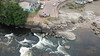
On the shortest day of the year — Dec. 21 — the shadow of one of the blocks disappears when the sun is directly above it.
"It is this block's alignment with the winter solstice that leads us to believe the site was once an astronomical observatory," said Mariana Petry Cabral, an archaeologist at the Amapa State Scientific and Technical Research Institute. "We may be also looking at the remnants of a sophisticated culture."
Anthropologists have long known that local indigenous populations were acute observers of the stars and sun. But the discovery of a physical structure that appears to incorporate this knowledge suggests pre-Columbian Indians in the Amazon rainforest may have been more sophisticated than previously suspected.
Read More at MSNBC and see also Mongabay for more information and photos.
IMPORTANT NOTE: Location is approximate
Note: A four year old story but one we missed at the time, an intriguing site
You may be viewing yesterday's version of this page. To see the most up to date information please register for a free account.
")
")
Do not use the above information on other web sites or publications without permission of the contributor.
Nearby Images from Flickr

The above images may not be of the site on this page, but were taken nearby. They are loaded from Flickr so please click on them for image credits.
Click here to see more info for this site
Nearby sites
Click here to view sites on an interactive map of the areaKey: Red: member's photo, Blue: 3rd party photo, Yellow: other image, Green: no photo - please go there and take one, Grey: site destroyed
Download sites to:
KML (Google Earth)
GPX (GPS waypoints)
CSV (Garmin/Navman)
CSV (Excel)
To unlock full downloads you need to sign up as a Contributory Member. Otherwise downloads are limited to 50 sites.
Turn off the page maps and other distractions
Nearby sites listing. In the following links * = Image available
217.7km NNW 340° Mont d'Argent rock art* Rock Art
689.9km SW 217° Santarém Settlements Ancient Village or Settlement
697.1km SW 223° Serra da Escama rock art* Rock Art
858.1km W 278° Corona Falls Petroglyphs Rock Art
1090.1km WNW 303° Wyva Creek Shell Mound Artificial Mound
1179.8km WSW 238° Area das Lajes Rock Art
1196.4km WSW 239° Acutuba Ancient Village or Settlement
1205.9km WSW 238° Hatahara* Ancient Village or Settlement
1206.6km WSW 238° Dona Stella Quarry Ancient Mine, Quarry or other Industry
1468.5km NW 309° Blanchisseuse Ancient Village or Settlement
1596.4km NW 313° Mt Rich Grenada (Caribbean)* Rock Art
1600.1km NW 313° Man-Face petroglyph (Union, Grenada)* Rock Art
1600.8km NW 313° Duquense Bay Petroglyphs, Grenada (Caribbean)* Rock Art
1602.2km NW 313° Rock Art near Waltham, Victoria, Grenada* Rock Art
1602.3km NW 313° Rock Art near Victoria, Grenada* Rock Art
1633.7km NW 317° St Vincent - Yambou Pass* Rock Art
1638.1km NW 317° St Vincent, Colonarie* Rock Art
1643.7km NW 317° St Vincent, Buccament* Rock Art
1647.3km NW 317° St Vincent - Borrouallie* Rock Art
1690.3km SE 124° Erere rock art* Rock Art
1766.6km SSE 164° Baixao-Tocantins rock art* Rock Art
1880.9km W 281° Orinoco Rock Art Rock Art
1901.2km NW 323° Trois Rivières Rock Carvings Rock Art
1998.9km NW 325° Indian Creek Ancient Village or Settlement
2018.8km ESE 123° Pedra do Ingá* Rock Art
View more nearby sites and additional images


 We would like to know more about this location. Please feel free to add a brief description and any relevant information in your own language.
 Wir möchten mehr über diese Stätte erfahren. Bitte zögern Sie nicht, eine kurze Beschreibung und relevante Informationen in Deutsch hinzuzufügen.
 Nous aimerions en savoir encore un peu sur les lieux. S'il vous plaît n'hesitez pas à ajouter une courte description et tous les renseignements pertinents dans votre propre langue.
 Quisieramos informarnos un poco más de las lugares. No dude en añadir una breve descripción y otros datos relevantes en su propio idioma.