Contributory members are able to log private notes and comments about each site
Sites theCaptain has logged. View this log as a table or view the most recent logs from everyone
Saint-Denec Alignement de Menhirs
Trip No.203 Entry No.508 Date Added: 27th May 2020
Site Type: Stone Row / Alignment
Country: France (Bretagne:Finistère (29))
Visited: Yes on 20th Jun 2005. My rating: Condition 3 Ambience 3 Access 5
Saint-Denec alignement de menhirs submitted by theCaptain on 31st Jan 2012. There is also a rather large menhir like stone laying at the foot of one of the menhirs, and there are other large stones laying in the fields nearby. I wonder if there was once a lot more here in the way of alignements?
On closer inspection of the fallen stone it can be seen that it has carvings on it. Two axes and a couple of the bishops crook shaped symbols (crosses). Not clearly seen in picture.
(View photo, vote or add a comment)
Log Text: The two St Dénec menhirs are standing in a field near to the farm of St Dénec. Both are about 3.5 to 4 metres high, but they are not nicely shaped and smoothed like most of the menhirs around here.
There is also a rather large menhir like stone laying at the foot of one of the menhirs, and there are other large stones laying in the fields nearby. I wonder if there was once a lot more here in the way of alignements?
On closer inspection of the fallen stone it can be seen that it has carvings on it. Two axes and a couple of the bishops crook shaped symbols (crosses). I was glad I went back for a second look after missing this first time round.
Saint Roch Menhir
Trip No.204 Entry No.185 Date Added: 24th Aug 2020
Site Type: Standing Stone (Menhir)
Country: France (Auvergne:Puy-de-Dôme (63))
Visited: Yes on 25th Jul 2005. My rating: Condition 3 Ambience 4 Access 3
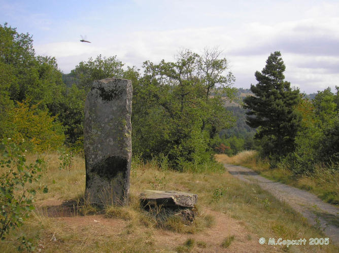
Saint Roch menhir submitted by thecaptain on 28th Jun 2006. This menhir can be found high up in the hills near St-Nectaire.
It's about 2 metres tall, and made from a hexagonal block of crystalline volcanic basalt.
(View photo, vote or add a comment)
Log Text: This menhir can be fairly easily found by following marked footpaths for a mile or so from St-Nectaire to Croix-St-Roche, high up on the hill, beside the track which passes from one valley to the next. It's about 2 metres tall, and made from a hexagonal block of crystalline volcanic basalt, the sort which they call orgues (organ pipes) round here. Very nice. If it weren't for all the trees, the views from here in many directions would be superb, with the Puy-de-Sancy mountain off to the west, across which are rolling lots of wet looking clouds ! Think I'd best get back.
Saint Fort Dolmen
Trip No.203 Entry No.237 Date Added: 22nd Apr 2020
Site Type: Burial Chamber or Dolmen
Country: France (Poitou:Charente (16))
Visited: Yes on 3rd Jun 2005. My rating: Condition 4 Ambience 3 Access 4

Saint Fort Dolmen submitted by Nick- on 24th Sep 2005. Strange dolmen, here's me 1m93 (6'4) for scale. I have a feeling that the capstone has been 'replaced'. I might be completely wrong of course. Easy access, Dolmen is signposted in the village of St.Fort.
(View photo, vote or add a comment)
Log Text: Signposted from the town of St Fort-sur-le-Ne, it is found about 1 kilometre to the east on top of a small hill amongst the Cognac vines. It is a real monster, looking like the skeletal remains of a dinosaur robot or something.
The chamber is 5 metres in length, by 2.5 metres wide, and the single, one metre thick capstone more than adequately covers that. It is held 2.5 metres high in the air by three large upright support stones, with the outline of the chamber having five more large stones in place.
Unfortunately, the poor thing suffers badly from graffitti, both written and carved, and it would seem to be used as a place for the local youth to come and drink, with empty bottles scattered all around. One of the side slabs has some strange carvings on it, perhaps a sort of window or entrance was once here, with the dolmen used as a house.
Sabatey Dolmen 2
Trip No.203 Entry No.226 Date Added: 22nd Apr 2020
Site Type: Burial Chamber or Dolmen
Country: France (Aquitaine:Gironde (33))
Visited: Yes on 3rd Jun 2005. My rating: Condition 2 Ambience 4 Access 4
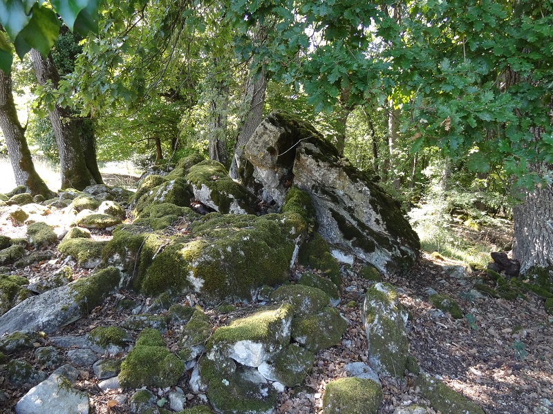
Sabatey Dolmen 2 submitted by johnstone on 18th Jan 2018. Sabatey-2 the sad remains on Sep 8, 2015
(View photo, vote or add a comment)
Log Text: Not the easiest dolmens to find, but they are signposted from the village of Bellefond to some degree, although a fair bit of guesswork is needed at certain junctions. Just to the left of Sabatey Farm, a gate opens into a field, from where you walk across to the woods, where the two dolmens can be seen on the right.
The first you find is Sabatey dolmen 2, which seems to mostly consist of a large pile of moss covered stones, with the remains of an allée-couverte sitting on top. A single remaining capstone has fallen, and the rest of the chamber is difficult to make out, but there are lots of large edge on stones present, possibly aligned on about 050°.
Sabatey Dolmen 1
Trip No.203 Entry No.227 Date Added: 22nd Apr 2020
Site Type: Burial Chamber or Dolmen
Country: France (Aquitaine:Gironde (33))
Visited: Yes on 3rd Jun 2005. My rating: Condition 3 Ambience 5 Access 4
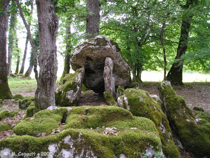
Sabatey Dolmen 1 submitted by thecaptain on 9th Jan 2006. Remains of two dolmens near to the village of Bellefond in Gironde.
Sabatey dolmen 1 is in the woods, and the remains of the allée-couverte on top are much more recogniseable tan its neighbour.
(View photo, vote or add a comment)
Log Text: Not the easiest dolmens to find, but they are signposted from the village of Bellefond to some degree, although a fair bit of guesswork is needed at certain junctions. Just to the left of Sabatey Farm, a gate opens into a field, from where you walk across to the woods, where the two dolmens can be seen on the right.
Sabatey dolmen 1 is about 25 metres into the woods, and although it at first appears to be a similar jumble of stones, the remains of the allée-couverte on top are much more recogniseable. It is about 6 metres long by 1.5 metres wide, with one capstone in place and a couple more fallen, with the chamber oriented eastwards at 094°. The end closing stone has some cupules carved into it.
Runesto Dolmen
Trip No.203 Entry No.393 Date Added: 14th May 2020
Site Type: Burial Chamber or Dolmen
Country: France (Bretagne:Morbihan (56))
Visited: Yes on 13th Jun 2005. My rating: Condition 4 Ambience 4 Access 4
Runesto dolmen submitted by TheCaptain on 14th Jun 2011. This dolmen is still mostly within it's mound, and in fact it has been cut down into with steps from the eastern side of the massive capstone.
(View photo, vote or add a comment)
Log Text: This is a pleasant dolmen still mostly within its mound, and in fact it has been cut down into with steps from the eastern side of the massive capstone. The chamber is about 3 metres by 3 metres, and the single capstone is held up on eight remaining side support stones, with plenty of room to stand up within. There are no longer any remains of its entry passageway which would have run off towards the east.
There are traces of engravings including a fairly good axe on the stone nearest to the entrance. Just outside to the east are two other large stones, which are perhaps related, but perhaps not. The wall of the nearby house has many large stones within it, no doubt being once part of the tumulus.
Rudston Monolith
Date Added: 7th Jun 2022
Site Type: Standing Stone (Menhir)
Country: England (Yorkshire (East))
Visited: Yes on 12th May 2022. My rating: Condition 4 Ambience 3 Access 5
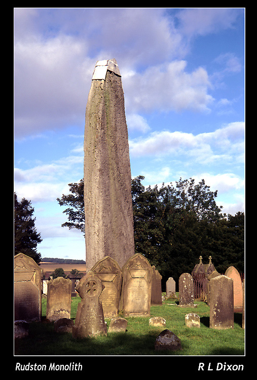
Rudston monolith submitted by rldixon on 25th Dec 2005. rudston monolith in colour
(View photo, vote or add a comment)
Log Text: A day to Scarborough from York, so made sure of a visit to this and Wetwang on the way. I was expecting to be slightly disappointed after all the French monster menhirs I have seen, but in actuality I was impressed. Its huge, and obviously well shaped. Only disappointment is the metal hat, and that its "caged" in the churchyard, rather than being wild and free. Also another small stone and cist grave in the corner of the churchyard. Lovely.
Royal Hill Cairns (SX621724)
Date Added: 29th Oct 2019
Site Type: Cairn
Country: England (Devon)
Visited: Yes on 2nd Aug 2006
Royal Hill Cairns (SX621724) submitted by thecaptain on 2nd Aug 2006. Royal Hill Cairn 5
Cairn 5 is easily found to the north of cairn 4, and about 100 metres distant from it.
This is a cute little thing with a complete stone ring around a central cist, but there is little remaining in the way of a cairn.
(View photo, vote or add a comment)
Log Text: None
Royal Hill Cairns (SX621723)
Date Added: 29th Oct 2019
Site Type: Cairn
Country: England (Devon)
Visited: Yes on 2nd Aug 2006
Royal Hill Cairns (SX621723) submitted by thecaptain on 2nd Aug 2006. Royal Hill Cairn 4
In the centre is a large cist, about 1 metre square, with its capstone displaced to the edge of the cairn.
(View photo, vote or add a comment)
Log Text: None
Royal Hill Cairns
Date Added: 18th Sep 2010
Site Type: Cairn
Country: England (Devon)
Visited: Yes on 2nd Aug 2006
Royal Hill Cairns (SX621723) submitted by thecaptain on 2nd Aug 2006. Royal Hill Cairn 4
In the centre is a large cist, about 1 metre square, with its capstone displaced to the edge of the cairn.
(View photo, vote or add a comment)
Log Text: None
Roundy Park settlement
Date Added: 5th Jun 2022
Site Type: Ancient Village or Settlement
Country: England (Devon)
Visited: Saw from a distance on 3rd May 2022

Roundy Park settlement submitted by TheCaptain on 5th Jun 2022. Roundy Park settlement seen clear on the other side of the East Dart valley from Hartland Tor.
(View photo, vote or add a comment)
Log Text: I now try to walk south from the Beehive Hut along the marked bridleway beside the Dart, but its hard going, very rough and largely overgrown, I find it to be much easier higher up on the moorland. South over the top of Hartland Tor with good views south towards Bellever Tor and Roundy Park settlement clear on the other side of the river. Onwards down to the Dart again, through the Hartyland estate to Postbridge, having a look at the old clapper bridge before getting a pint of Jail Ale in the welcoming East Dart Hotel bar.
Rougié Dolmen
Trip No.203 Entry No.137 Date Added: 10th Apr 2020
Site Type: Burial Chamber or Dolmen
Country: France (Midi:Lot (46))
Visited: Yes on 24th May 2005. My rating: Condition 3 Ambience 3 Access 3
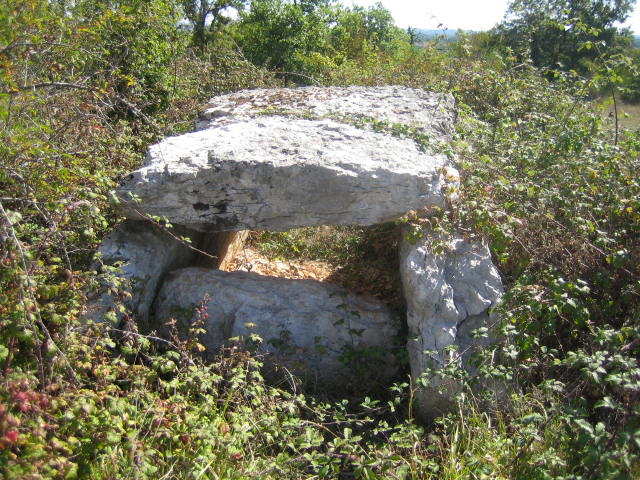
Rougié dolmen submitted by MichelDRN on 14th Oct 2005. The Rougié dolmen is located 2.750m NW from Livernon church, 250m NW from the 'Pierre Martine' dolmen, in open field.
(View photo, vote or add a comment)
Log Text: Just a hundred metres or two behind the Pierre Martine, beyond the fence and up the slope into the adjacent field, can be found this dolmen sitting in a field full of thistles, surrounded by brambles and scrub. Despite the many people who visit the Pierre Martine, hardly anybody knows of the existence of this dolmen. It is about 3 metres long with a capstone broken into two pieces, and faces 085°
Roughtor well
Date Added: 24th Jul 2022
Site Type: Holy Well or Sacred Spring
Country: England (Cornwall)
Visited: Yes on 13th Sep 2014. My rating: Condition 3 Ambience 4 Access 3
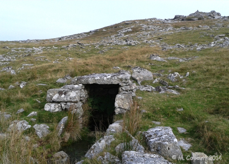
Roughtor well submitted by theCaptain on 11th Jan 2015. I am amazed that I never knew of its existence in the past (ah, I see, rediscovered and restored in 1994).
A nice stone trough and well front has been built over a fairly vigorous spring quite high up on the Roughtor Massif, approximately halfway between the main Roughtor top and the Showery Tor top on the north-western hillside.
(View photo, vote or add a comment)
Log Text: This was a nice find, and I am amazed that I never knew of its existance in the past. A nice stone trough and well front has been built over a fairly vigourous spring quite high up on the Roughtor Massif, approximately halfway between the main Roughtor top and the Showery Tor top on the northwestern hillside. It is fairly easy to find amongst all of the other natural clitter on a clear day, as the stream which runs out from it can be seen at is traces its way down the hillside. The well can be simply found at the top of this! There were a few little offerings strewn amongst the stones on the afternoon of my visit.
Roughtor Summit Cairns
Date Added: 15th Mar 2023
Site Type: Cairn
Country: England (Cornwall)
Visited: Yes on 13th Jun 2022. My rating: Condition 3 Ambience 4 Access 3
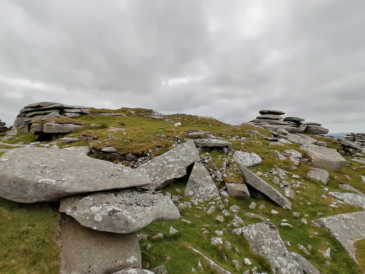
Roughtor Summit Cairns submitted by TheCaptain on 11th Jul 2022. Showing the cairn structure around the natural outcrops at the summit of Roughtor
(View photo, vote or add a comment)
Log Text: Remains of cairns created round some natural outcrops within the settlement on the top of Roughtor, near to the memorials.
Roughtor South
Date Added: 18th Sep 2010
Site Type: Ancient Village or Settlement
Country: England (Cornwall)
Visited: Yes on 11th Apr 2005

Roughtor South submitted by TheCaptain on 11th Apr 2005. One of the multitude of field walls at the western side of the Roughtor South village.
Brown Willy looking nice on the horizon to the south east.
(View photo, vote or add a comment)
Log Text: None
Roughtor South
Date Added: 24th Jul 2022
Site Type: Ancient Village or Settlement
Country: England (Cornwall)
Visited: Yes on 13th Jun 2022. My rating: Condition 3 Ambience 4 Access 2

Roughtor South submitted by TheCaptain on 11th Apr 2005. A hut circle at the Roughtor South village. Many of the buildings here seem to be complex double or treble roomed dwellings.
View looking north towards Roughtor itself.
(View photo, vote or add a comment)
Log Text: North of the stone circle, and south of the bulk of Roughtor are the remains of a large and complex settlement
Roughtor settlement
Date Added: 24th Jul 2022
Site Type: Ancient Village or Settlement
Country: England (Cornwall)
Visited: Yes on 13th Sep 2014. My rating: Condition 3 Ambience 4 Access 3
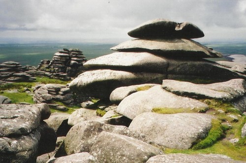
Roughtor settlement submitted by Bladup on 21st Apr 2013. Inside the amazing Roughtor Neolithic settlement.
(View photo, vote or add a comment)
Log Text: Around the top of the Roughtor hilltop, from Little Roughtor in the northeast to the main Roughtor summit in the southwest, can be seen the remains of a stone bank encircling the hilltop. In places this stone bank remains very significant, but in other places, particularly on the steeper slopes, it is less significant, probably due to stones falling off and rolling down the hillside amongst all of the other clitter. There are remains of a few cairns and hut circles within this enclosure.
Roughtor North cairn X
Date Added: 29th Oct 2019
Site Type: Round Cairn
Country: England (Cornwall)
Visited: Yes on 12th Jun 2015

Roughtor North cairn X submitted by TheCaptain on 12th Jun 2015. Remains of a round cairn near to the lower end of the Roughtor Long Cairn, not far from the way onto the open moor from the parking area.
(View photo, vote or add a comment)
Log Text: None
Roughtor north
Date Added: 29th Oct 2019
Site Type: Ancient Village or Settlement
Country: England (Cornwall)
Visited: Yes on 11th Jan 2015

Roughtor north submitted by theCaptain on 11th Jan 2015. My memory tells me that there are many round houses and enclosed farmsteads on the northern slopes of roughtor, many in a fine state of conservation, but until we were almost right down at the bottom there was little other than very damaged sites to be seen.
However, down low beside the river and many enclosed farmsteads with their round houses built into the walls can be seen.
I do believe I must have been spoiled by some of the much better preserved hut circles and farmsteads I hav...
(View photo, vote or add a comment)
Log Text: None
Roughtor north
Date Added: 24th Jul 2022
Site Type: Ancient Village or Settlement
Country: England (Cornwall)
Visited: Yes on 13th Jun 2022. My rating: Condition 3 Ambience 4 Access 3
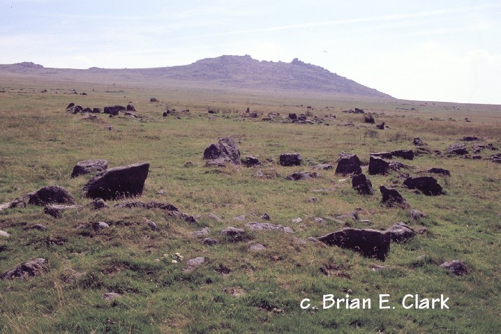
Roughtor north submitted by bec-zog on 26th Mar 2004. ROUGH TOR SX141815
Prehistoric Bronze Age landscape: well preserved group of hut circles, cairns, burial chambers & associated structures.
(View photo, vote or add a comment)
Log Text: To the northwest of the bulk of Roughtor is a very large and strung out settlement, and cairns.
