Contributory members are able to log private notes and comments about each site
Sites theCaptain has logged. View this log as a table or view the most recent logs from everyone
Tiergues Dolmen
Trip No.203 Entry No.180 Date Added: 19th Apr 2020
Site Type: Burial Chamber or Dolmen
Country: France (Midi:Aveyron (12))
Visited: Yes on 28th May 2005. My rating: Condition 4 Ambience 3 Access 5
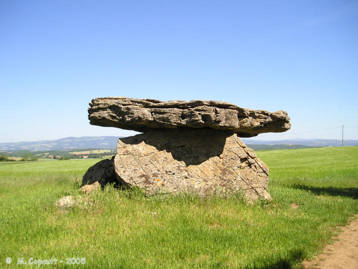
Tiergues Dolmen submitted by thecaptain on 18th Dec 2005. The lovely Dolmen de Tiergues, in its splendid Aveyron scenery.
This is the southern side view, with strange linear markings on the sideslab.
(View photo, vote or add a comment)
Log Text: Near to the village of Tiergues, in Aveyron, this is a lovely dolmen, as used in postcards and much Aveyron tourist publicity. It is not far from the D.250 road and signposted from the main D.992 road nearby.
The dolmen is 4 metres long, and 2 metres in both height and width, it has two good long side slabs, with a broken and falling back stone. On top of these there is a good capstone, which is very level, covering a chamber which opens to the northeast at 065°.
While posing for a picture here, the dolmen bit me, as I stood up and hit my head on the capstone, which overhangs the sidestones at the front quite considerably. There are meagre remains of a mound, and a few other large bits of stone surround it.
Thunder Stone (Shap)
Date Added: 9th Oct 2022
Site Type: Natural Stone / Erratic / Other Natural Feature
Country: England (Cumbria)
Visited: Yes on 19th Sep 2022. My rating: Condition 2 Ambience 2 Access 4
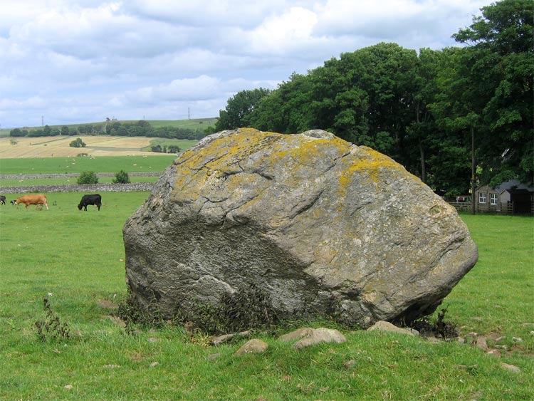
Thunder Stone submitted by LivingRocks on 7th Jul 2005. The enormous Thunder Stone, the largest stone of the Shap Avenue.
(View photo, vote or add a comment)
Log Text: At the northwest end of the avenue is the large Thunder Stone, a view of which can be had across the field near the farm.
Thunder Stone (Castlehowe Scar)
Date Added: 14th Oct 2022
Site Type: Natural Stone / Erratic / Other Natural Feature
Country: England (Cumbria)
Visited: Yes on 19th Sep 2022. My rating: Condition 3 Ambience 3 Access 5
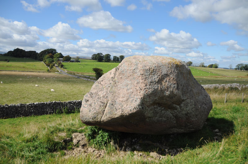
Thunder Stone (Castlehowe Scar) submitted by Anne T on 8th Sep 2014. Another face of this Thunder Stone. The red of the Shap Granite can be clearly seen in the strong sunlight.
(View photo, vote or add a comment)
Log Text: Head out to the east of Shap, and the first stop is another Thunder Stone, this one an erratic perched just above a small old quarry, looming large on the skyline when approaching from the west.
Three Hole Cross
Date Added: 29th Oct 2019
Site Type: Ancient Cross
Country: England (Cornwall)
Visited: Yes on 20th Oct 2014
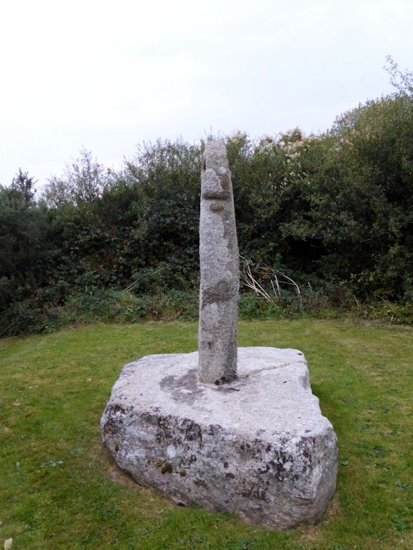
Three Hole Cross submitted by theCaptain on 20th Oct 2014. This lovely cross has been restored and remounted on a large granite base in a piece of land beside the busy junction.
(View photo, vote or add a comment)
Log Text: None
Three Boys
Date Added: 18th Sep 2010
Site Type: Standing Stone (Menhir)
Country: England (Devon)
Visited: Yes on 15th Oct 2004
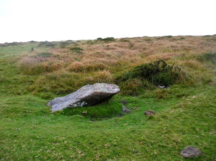
Three Boys submitted by thecaptain on 15th Oct 2004. Nearly 2 metres long, this fairly large, almost fallen stone was probably once a blocking stone at the southern end of Shovel Down row 6.
Viewed looking northwest with a row 6 stone under the gorsebush
(View photo, vote or add a comment)
Log Text: None
Thornwell Round Barrow
Date Added: 31st Mar 2022
Site Type: Round Barrow(s)
Country: Wales (Monmouthshire)
Visited: Yes on 11th Nov 2006. My rating: Condition 2 Ambience 2 Access 5
Thornwell Round Barrow submitted by thecaptain on 15th Nov 2006. About 100 metres to the east of the chambered tomb, the remains of a bronze age round barrow can be found in another green grassy area left between the houses.
The large oak tree growing in the chambered tomb can be seen above the rooftops to the left of centre.
(View photo, vote or add a comment)
Log Text: About 100 metres to the east of the chambered tomb, following a footpath up between the houses, the remains of a bronze age round barrow can be found in another green grassy area left between the houses. Its about 10 metres in diameter, and in a few places an occasional stone can be seen to be sticking through the grass.
Thornwell Farm
Date Added: 31st Mar 2022
Site Type: Chambered Tomb
Country: Wales (Monmouthshire)
Visited: Yes on 11th Nov 2006. My rating: Condition 2 Ambience 2 Access 5
Thornwell Round Barrow submitted by thecaptain on 15th Nov 2006. About 100 metres to the east of the chambered tomb, the remains of a bronze age round barrow can be found in another green grassy area left between the houses.
The large oak tree growing in the chambered tomb can be seen above the rooftops to the left of centre.
(View photo, vote or add a comment)
Log Text: On a housing estate to the south of Chepstow, right beside the Severn Bridge motorway junction from where it can be seen, are to be found the sad remains of a once major neolithic chambered tomb. It is to be found on a green space between the houses of Fountains Way and the back of a shopping area, and has a very large old oak tree growing on top of it. Under the tree can be seen remains of a large mound with various rocks sticking out, particularly on the northern side. Closer inspection of the high ground beside the tree reveals what looks to be the remains of a tomb chamber. Several edge set stones are to be seen sticking out of the ground, forming a rectangular structure about 3 metres by 2 metres, with a right angle incorporated – perhaps remains of an entrance and side chamber ? Below the tree the ground drops away quite steeply, and indeed may be the remains of the edge of the tomb, which has been shown to have once consisted of a large drystone wall surrounded structure. Within the rubble in this bank are several large stone slabs, which may once have been part of a side chamber. The stones are the local hard puddingstone type conglomerate of sandstone with gravel in it. When I was visiting, I was not sure whether this was the right place for this tomb, and so asked a local lady. She told me that although she did not know what was there, she had been told that her views would never be spoiled because no new building would ever be allowed on the green space because of some historical site. Excavations here in the past have revealed drystone walling, one main and two side chambers (one with a porthole) plus human bones, pottery, flints etc.
Thornwell Farm
Date Added: 31st Mar 2022
Site Type: Chambered Tomb
Country: Wales (Monmouthshire)
Visited: Yes on 26th Mar 2022. My rating: Condition 3 Ambience 3 Access 5
Thornwell Farm submitted by thecaptain on 15th Nov 2006. On a housing estate to the south of Chepstow, are to be found the sad remains of a once major neolithic chambered tomb.
It is on a green space between the houses of Fountains Way, and has a very large old oak tree growing on top of it.
Under the tree can be seen remains of a large mound with various rocks sticking out, particularly on the northern side.
(View photo, vote or add a comment)
Log Text: Walking the Welsh Coast Path from Chepstow to Caldicot. Remains of a chambered longbarrow on a green area in the housing estate of Thornwell, near to the motorway junction south of Chepstow. Remains of two slab sided chambers can still be seen when the undergrowth is low.
Thorncombe Hill Cairns
Date Added: 29th Oct 2019
Site Type: Barrow Cemetery
Country: England (Somerset)
Visited: Yes on 17th Nov 2017
Thorncombe Hill Cairns submitted by TheCaptain on 17th Nov 2017. Remains of several barrows on Thorncombe Hill, part of the Quantock Hills ridge
(View photo, vote or add a comment)
Log Text: None
Thorncombe Barrow
Date Added: 29th Oct 2019
Site Type: Cairn
Country: England (Somerset)
Visited: Yes on 17th Nov 2017
Thorncombe Barrow submitted by TheCaptain on 17th Nov 2017. Large 17m diameter bowl barrow on Thorncombe Hill high above the Trendle Ring at the top of the Quantock Hills ridge.
There was a freezing cold wind, and some heavy showers, so we did not delay our walk by detouring to look at this barrow.
(View photo, vote or add a comment)
Log Text: None
Thornborough S
Date Added: 3rd Feb 2023
Site Type: Henge
Country: England (Yorkshire (North))
Visited: Yes on 27th Sep 2022. My rating: Condition 3 Ambience 3 Access 4
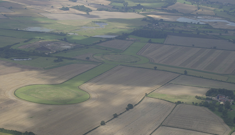
Thornborough S submitted by JJ on 23rd Aug 2004. Thornborough south henge
(View photo, vote or add a comment)
Log Text: Travelling home from Northumberland, and the weather forecast was good, so I decided to go the eastern route and break my journey to have a look at the Thornborough Henges. After a drive around several small roads, I found a place to park with access to the fields between the southern and central henges. I decided to go walk around the henges, and started with the southern one, a fair walk on a blowy day, but nice when the sun came out. The large henge is not so well formed as I had expected, no doubt worn down over the centuries, and not much to see other than the circular bank; the internal ditch is barely noticeable.
Thornborough N
Date Added: 3rd Feb 2023
Site Type: Henge
Country: England (Yorkshire (North))
Visited: Yes on 27th Sep 2022. My rating: Condition 5 Ambience 4 Access 4
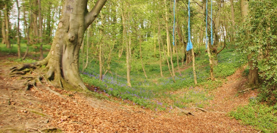
Thornborough N submitted by SumDoood on 24th Apr 2017. (Arriving only just in time, I had cut down the four Roman soldiers and told them to get their sorry European arses back to Boroughbridge, and not to bother my henge again. Meanwhile...) I was very impressed by this henge and the fact that it is still so complete, the ditch being on average 3.0m deep and the bank an average of 3.0m high.
(View photo, vote or add a comment)
Log Text: Back to the car for the small drive round to the woodland at the western side of the northern henge, and there was room to park, and then follow one of several paths into the woodland. This northern henge is much more like it, very well preserved, both the banks and internal ditch. The atmosphere in this woodland is much more pleasant than the open fields of the other two. Time to look for a pub and a pint.
Thornborough Central
Date Added: 3rd Feb 2023
Site Type: Henge
Country: England (Yorkshire (North))
Visited: Yes on 27th Sep 2022. My rating: Condition 3 Ambience 3 Access 4
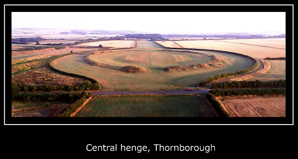
Thornborough Central submitted by Iain_P on 8th Sep 2016. This is an image taken from stitched together frames from a drone video, taken at sunrise a month ago (early August, 2016) For scale, you can just see our car in the bottom right.
(View photo, vote or add a comment)
Log Text: Crossing back across the roadway, I go in for a look and walk around the central henge. This banks of this one are more substantial, but in places are very damaged by badgers or rabbits. The internal ditch is again slight, but can be made out here. I walked north to try to get to the northern henge, but it was not possible to get across the northern road and in to see it.
Thiemblais menhir
Trip No.203 Entry No.597 Date Added: 10th Jun 2020
Site Type: Standing Stone (Menhir)
Country: France (Bretagne:Côtes-D'Armor (22))
Visited: Yes on 27th Jun 2005. My rating: Condition 5 Ambience 5 Access 4

Thiemblais menhir submitted by thecaptain on 16th May 2007. Thiemblais, or St-Samson, menhir, near to Dinan. The signpost.
From what I saw of the carvings on the south side of the menhir in reality, the drawings on the signboard do not do it justice.
(View photo, vote or add a comment)
Log Text: This is a truly wonderful 8 metre long granite menhir, which can be found signposted along a little track just to the east of the village of St Samson.
Although it leans at about 45°, it is beautifully shaped and has multitudes of carvings and engravings all over it. Apparently those on the flat western face are easy to see at mid day, but when I was here at 7:00pm, I could barely make anything out. I could, however, clearly see some of the carvings on the two sides, with the shadows being cast in just the right direction. All of the usual neolithic symbols are here, crosses, axes, squares, palettes and serpents.
A nice legend of the stone is that any young girl who wants to get married should climb to the top of the stone, and side down in their "birth knickers", and they will become wed within the year. It is also supposed to be one of the three menhirs that block the entrance to hell. A real fantastic find.
Thiemblais menhir
Trip No.208 Entry No.3 Date Added: 10th Jun 2020
Site Type: Standing Stone (Menhir)
Country: France (Bretagne:Côtes-D'Armor (22))
Visited: Yes on 20th Mar 2008. My rating: Condition 5 Ambience 5 Access 4
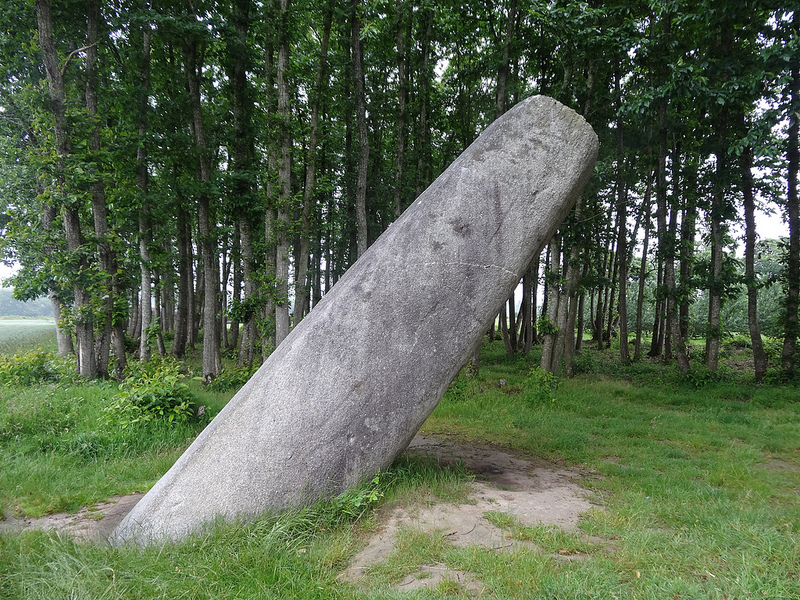
Thiemblais menhir submitted by neolithique02 on 21st Feb 2014. Le menhir de Saint-Samson sur Rance (Côtes d'Armor) Site in Bretagne:Côtes-D''Armor (22) France
Image copyright: Néolithique02, hosted on Flickr and displayed under the terms of their API.
(View photo, vote or add a comment)
Log Text: My second visit to this most wonderful menhir, about 1:30pm, late March 2008, in a hazy sun, and some of the carvings on the front face can be seen. An hour or two earlier would have been better, as would a stronger sun. After a while, you "get your eye in" and more and more wonderful carvings come into view. I can see on here (with the eye of the knowing, and the full def picture) the animal (mid left, just above the quartz vein) and a couple of crosses and other bits and pieces.
Having got hold of a new book about the megalithes around Dinan, I can report that a revised picture of the carvings has been published in the last year or so, after various techniques have been used to make the carvings more prominent. These seem to agree more with what I saw several years ago and have been recorded in my photographs. Mind you, it seems that the "animal" on the mid left of the stone may have turned around, and its legs almost doubled in length !!! Now it is perhaps running to the right, rather than grazing to the left....
But to be serious for a while, this really is one of the most magnificent megalithic sites I have visited, and it has the capability of bringing emotions to the surface. Here is plain evidence of the cross symbol being used at important places 2500 years or more BC. And the importance of the animals....
And the shaping of the stone - look how flat the main face is, and how straight the upright edges are, even after about 5000 years of erosion. And this surely couldn't have been a one off ? Surely many more of these wonderful menhirs would have been carved and patterned ? Damn all those girls and floozies who have climbed and slid down the stone in their birth knickers in the hope of getting wed. The front face is almost polished smooth, with the carvings almost rubbed smooth.
Thedes Menhir
Trip No.204 Entry No.192 Date Added: 24th Aug 2020
Site Type: Standing Stone (Menhir)
Country: France (Auvergne:Puy-de-Dôme (63))
Visited: Saw from a distance on 26th Jul 2005
Thedes menhir submitted by ocdolmen on 20th Sep 2009. Site in Auvergne: Puy-de-Dôme (63) France: Thedes menhir
(View photo, vote or add a comment)
Log Text: Approximately 2 metre tall menhir with an iron cross mounted on the top of it. It is to be found at the D.5 and D.90 road junction just to the west of the hamlet of Theddes, and is marked as a cross on the ign map. I must have driven right by it, perhaps twice.
The Toots (Oldbury)
Date Added: 18th Sep 2010
Site Type: Hillfort
Country: England (Gloucestershire)
Visited: Yes on 22nd Apr 2009

The Toots (King's Stanley) submitted by thecaptain on 22nd Apr 2009. The Toots - seen on the skyline of Selsley common above the church. Viewed here from Stroud
(View photo, vote or add a comment)
Log Text: None
The Toots (Oldbury)
Date Added: 9th Sep 2020
Site Type: Hillfort
Country: England (Gloucestershire)
Visited: Yes on 3rd Jun 2020. My rating: Condition 3 Ambience 3 Access 4
The Toots (Oldbury) submitted by 4clydesdale7 on 4th Jul 2011. The best evidence of the Fort - the NNE rampart looking SE
(View photo, vote or add a comment)
Log Text: At the end of a walk along the Severn estuary and all round the old Oldbury Nuclear Powerstation, I walked back to Oldbury-on-Severn right through the Toots camp. Nice roadsign leading to it, and some information boards have now been put up in the village.
The Toots (King's Stanley)
Date Added: 23rd Oct 2021
Site Type: Long Barrow
Country: England (Gloucestershire)
Visited: Yes on 14th Mar 2009. My rating: Condition 3 Ambience 4 Access 4

The Toots (King's Stanley) submitted by thecaptain on 22nd Apr 2009. The Toots - seen on the skyline of Selsley common above the church. Viewed here from Stroud
(View photo, vote or add a comment)
Log Text: Remains of a large unexcavated Long Barrow on the Cotswold escarpment slopes of Selsley Common, just to the south of Stroud in Gloucestershire. Possibly called 'The Toots' because of a hollow in the middle which makes it look as if it is composed of two mounds. The views on a good day from here are terrific, and the common is a favourite place for dogwalkers, kite flyers and model plane flying.
The Toots (King's Stanley)
Date Added: 23rd Oct 2021
Site Type: Long Barrow
Country: England (Gloucestershire)
Visited: Yes. My rating: Condition 3 Ambience 4 Access 4

The Toots (King's Stanley) submitted by AngieLake on 21st Oct 2015. Facing WSW on 22nd Sept with the glare of the setting sun at Equinox highlighting the dips and bumps on top of The Toots. The River Severn is glimpsed in the distance, top right. Views are spectacular up here!
(View photo, vote or add a comment)
Log Text: Walking "The Selsey Circuit" of the Cotswold Way with San, and passed over the Toots. Snow on the hilltops!
