Contributory members are able to log private notes and comments about each site
Sites theCaptain has logged. View this log as a table or view the most recent logs from everyone
Champ Dolent Menhir
Trip No.208 Entry No.6 Date Added: 13th Jun 2020
Site Type: Standing Stone (Menhir)
Country: France (Bretagne:Ille-et-Vilaine (35))
Visited: Yes on 20th Mar 2008. My rating: Condition 5 Ambience 4 Access 5
Champ Dolent menhir submitted by rw1 on 2nd Mar 2008. 09/2007
(View photo, vote or add a comment)
Log Text: None
La Roche Longue (St-Marcan)
Trip No.209 Entry No.13 Date Added: 13th Jun 2020
Site Type: Standing Stone (Menhir)
Country: France (Bretagne:Ille-et-Vilaine (35))
Visited: Yes on 12th Jun 2009. My rating: Condition 4 Ambience 3 Access 4
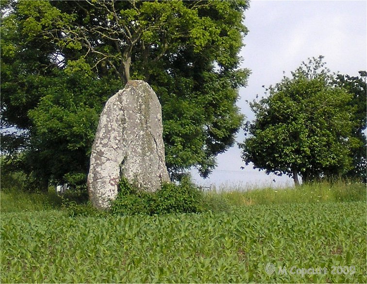
La Roche Longue (St-Marcan) submitted by thecaptain on 30th Jun 2009. View of La Roche Longue seen from the west.
(View photo, vote or add a comment)
Log Text: This well shaped menhir is just under 3 metres tall in a field to the east of the St Marcan cemetary. As with my previous visit, the field is planted with maize, and is today sodden wet, which prevents me from being abole to walk right up to the stone. However, this time I can walk up the western edge of the field by the cemetary, and photograph its other side in the afternoon sunshine.
Menhir du Perron (St-Marcan)
Trip No.209 Entry No.14 Date Added: 13th Jun 2020
Site Type: Standing Stone (Menhir)
Country: France (Bretagne:Ille-et-Vilaine (35))
Visited: Yes on 12th Jun 2009. My rating: Condition -1
Log Text: A 2 metre tall menhir similar to the Roche Longue of St Marcan, once stood in the fields of Perron, about 800 metres south of La Roche Longue. It somehow disappeared in the 1930's.
Four-És-Feins
Trip No.209 Entry No.10 Date Added: 13th Jun 2020
Site Type: Passage Grave
Country: France (Bretagne:Ille-et-Vilaine (35))
Visited: Yes on 12th Jun 2009. My rating: Condition 2 Ambience 4 Access 3
Four-És-Feins submitted by karolus on 12th Jan 2018. Site in Bretagne:Ille-et-Vilaine (35) France
(View photo, vote or add a comment)
Log Text: I went and had another look for this while in the area last weekend, now knowing to look nearby to the Beillac farm. I could see nothing obvious when driving slowly down the lane past the farm, but there was an old couple out tending their wonderful vegetable garden, so I stopped and asked them if they could tell me where the dolmen was. They were interested to know what an Englishman was doing looking for the remnants of the dolmen, but were happy to help.
Unfortunately, I struggled to understand fully all they were saying, a combination of strong accent and using some words I just could not figure out. But I thought I had got enough of a lead to find it easily. Park out of the way of the farm track by the corner of the farm. Cross the field to the south on the newly cut hay at the edge of the field for 200 metres until reaching the other side. Go straight on about another 100 metres (unknown words) until I get to the big trees, and it is on the left, (some more unknown words). Put boots on if you have them. Sounds simple.
Well, it was all very simple simple, until I tried to decide which of all the woodlands were the correct big trees. However, after a few false starts, I found a place in a woodland to the left of the track, with a mound in it, and what looked to be some lumps sticking up, but it was very overgrown. It has to be this, surely. Closer inspection amongst the ivy and brambles, and there were clearly a few side set slabs sticking up through the ground, and I was pretty sure I could determine two rows of slabs about 1.5 metres apart from each other, but with no stone more than 0.5 metres tall, and most substantially lower. I reckoned that what I had found on top of the mound was about 10 metres in length, and had to be the remains of a very ruined allée couverte.
However, walking back to the car, I thought that these poor remains were not really enough to be known by the name Four-es-Feins; the Fairies Oven. Surely something with a name like that must be a grander structure. I also thought it to be too ruined to be what the old couple were explaining to me, although they did say it was just the remains of an allée couverte. I would have thought they would have told me not to bother rather than gladly give me directions.....
Upon returning to the car, I remembered I had book with description in a box in the boot. "Rectangular chamber measuring 10m by 1.5m with 6 orthostats on the south side and 5 on the north. Their length is between 1 and 1.8 metres, height about half a metre and thickness 0.3 metres. Brilliant, this all fits to what I saw. But then, the description goes on. Three cover slabs about half a metre thick, and the backstone are still in place. Around the monument, a dozen or so other stones lie scattered.
Well, I can believe the stones are now more covered by undergrowth and soil than that description, and hence seem smaller. The size, orientation and almost everything seems right, with one major exception; the three cover stones. There was nothing at all which could have been them. Read the description again and realise it has been based upon a plan and writings from 1886 and 1928. Maybe it has become much more wrecked since then, but what of the old couples talk ?
So, was this Four-es-Feins or not? If it wasn't, what had I found ? I am not sure, but like to think I did find it. Certainly until anyone proves otherwise and can show me something better I'll count it.
Roche-aux-Fées (Essé)
Trip No.210 Entry No.2 Date Added: 16th Sep 2020
Site Type: Passage Grave
Country: France (Bretagne:Ille-et-Vilaine (35))
Visited: Yes on 3rd Jun 2010. My rating: Condition 5 Ambience 5 Access 5
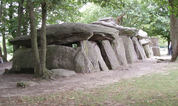
Roche-aux-Fées (Essé) submitted by AlexHunger on 21st Sep 2004. Roches Aux Fees viewed from North West
(View photo, vote or add a comment)
Log Text: June 2010 visit to France to see my sister, and as usual I had my Dad with me. I had decided on a long detour to visit La Roche-aux-Fées, but before we came here, I had told him nothing about it, except to say we were going to visit somewhere special. He is well used to me taking him to old stones all over the place, often on wild goose chases in woods and across fields finding nothing. But not this time.
This monument is now presented quite differently to when I previously visited in 2005, with a large new car park and visitor centre in what would have been fields to the south. Unfortunately, the visitor centre was closed, being open at weekends and holidays only this time of year until July and August when it becomes daily. I have read that this centre is very good, and with a decent book and gift shop.
From the visitor centre, a pathway leads through a nicely landscaped area towards the monument itself, which is hidden behind trees and hedges, until you round the end of a hedge (with a large fallen stone at the corner), and then there it is, in all its splendor, viewed towards the wonderful portal entrance. Even on my second visit here, it is awe inspiring, especially the work on the portico, which is over 4500 years old and still completely level.
My Dad was well impressed too, and couldn’t quite believe what he was seeing. “Oh My!, How can this be so big? What’s this for?” he asked. “It can’t be just to bury somebody in. All these separate room bits? Why? It’s a bit like the side chapels in a Cathedral”. Pretty much my thoughts exactly, and it is good to hear these things coming from somebody else with no prompting.
Somebody had made little piles of pebbles and other decorative bits and pieces placed at various places, which looked good. I am impressed by one of the massive capstones which seems to have been fitted exactly into a gap in the supporting side stones. This place is truly absolutely fantastic. I don’t have the words for it.
The new field around the monument has been splendidly done, and gives it the space it needs. Only two other people came to visit in the time we were here, a large improvement over my previous August Saturday visit. One downside are the various noticeboards now erected here, stating that cracks have been found in some of the stones, and people should be careful and not climb on the stones. I hope that there is no bad damage to the place. What would the Fairies think?
Ménec alignements
Trip No.203 Entry No.383 Date Added: 11th May 2020
Site Type: Multiple Stone Rows / Avenue
Country: France (Bretagne:Morbihan (56))
Visited: Yes on 12th Jun 2005. My rating: Condition 5 Ambience 5 Access 5

Ménec alignements submitted by thecaptain on 18th Oct 2004. Ménec alignements, north of Carnac, Brittany, France.
View of the Menec Alignements as they were in summer 1987, when you could walk amongst them.
I must go back for another visit sometime
(View photo, vote or add a comment)
Log Text: Fantastic in the evening light, and I have them almost all to myself.
Kermario Dolmen
Trip No.203 Entry No.377 Date Added: 11th May 2020
Site Type: Burial Chamber or Dolmen
Country: France (Bretagne:Morbihan (56))
Visited: Yes on 12th Jun 2005. My rating: Condition 4 Ambience 3 Access 5
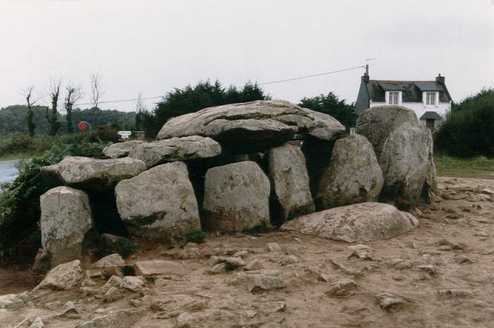
Kermario Dolmen submitted by thecaptain on 18th Oct 2004. Kermario Dolmen, north of Carnac, Brittany.
View of the Kermario Dolmen which is right at the southwest corner of the Kermario Alignements, and right in the corner of the road which skirts the site.
This picture was taken in 1987 when people were free to wander amongst the stones as they pleased. The terrible erosion caused by all the visitors is only too obvious.
(View photo, vote or add a comment)
Log Text: None
Kermario Alignements
Trip No.203 Entry No.378 Date Added: 11th May 2020
Site Type: Multiple Stone Rows / Avenue
Country: France (Bretagne:Morbihan (56))
Visited: Yes on 12th Jun 2005. My rating: Condition 5 Ambience 4 Access 5

Kermario Alignements submitted by thecaptain on 18th Oct 2004. Kermario Alignements, north of Carnac, Brittany.
View of some of the enormous stones which go to make up part of the Kermario Alignements. This picture was taken in 1987 when people were free to wander amongst the stones as they pleased. The terrible erosion caused by all the visitors is only to obvious.
(View photo, vote or add a comment)
Log Text: I am not going to say much about the major Carnac alignements, except to say that they are all absolutely mind blowing. Even though I saw them all those years ago, the first sight of all those stones lined up is incredible, especially in the strong evening sunshine.
I cannot possibly do justice to these stones with my writing or photographs. I will say that the fences surrounding the stones are not obtrusive, unlike the fences at stonehenge, and with the vegetation returning, they all look FAR, FAR better than they did in 1987 with all the soil erosion around them all. I must come back and do the full tour at some time.
Kerlescan Alignements
Trip No.203 Entry No.380 Date Added: 11th May 2020
Site Type: Multiple Stone Rows / Avenue
Country: France (Bretagne:Morbihan (56))
Visited: Yes on 12th Jun 2005. My rating: Condition 5 Ambience 5 Access 5

Kerlescan Alignements submitted by thecaptain on 18th Oct 2004. Kerlescan Alignements, northeast of Carnac, Brittany.
This picture was taken looking west in 1987, when wandering amongst the stones was OK. I think many of them have been fenced off to try and combat erosion these days. I must go back sometime.
(View photo, vote or add a comment)
Log Text: I am not going to say much about the major Carnac alignements, except to say that they are all absolutely mind blowing. Even though I saw them all those years ago, the first sight of all those stones lined up is incredible, especially in the strong evening sunshine.
I cannot possibly do justice to these stones with my writing or photographs. I will say that the fences surrounding the stones are not obtrusive, unlike the fences at stonehenge, and with the vegetation returning, they all look FAR, FAR better than they did in 1987 with all the soil erosion around them all. I must come back and do the full tour at some time.
Saint-Michel tumulus
Trip No.203 Entry No.411 Date Added: 21st May 2020
Site Type: Chambered Cairn
Country: France (Bretagne:Morbihan (56))
Visited: Yes on 14th Jun 2005. My rating: Condition 4 Ambience 2 Access 4

Saint-Michel tumulus submitted by thecaptain on 29th Oct 2004. Tumulus St Michel, just north of Carnac, Brittany.
This massive tumulus is 120m long and 12 metres high, with a chapel built on top of it. It is (or was when I was there in 1987) possible to visit inside the mound and see the two large chambers and many smaller stone lined cists.
Many artefacts were found during past excavations, lots of which can be found in the Carnac Museum.
(View photo, vote or add a comment)
Log Text: Very old and big. Visits inside no longer available like they were in the 1980s.
Mané Keriaval
Trip No.203 Entry No.391 Date Added: 14th May 2020
Site Type: Passage Grave
Country: France (Bretagne:Morbihan (56))
Visited: Yes on 13th Jun 2005. My rating: Condition 4 Ambience 4 Access 4

Mané Keriaval submitted by thecaptain on 27th Jan 2005. Mané Keriaval as it was back in 1987.
(View photo, vote or add a comment)
Log Text: Now this is a nice one, not only for the monument, but it is signposted and not being worn away by masses of visitors. Best of all, it has obviously been cleared within the last day or so of all the undergrowth which was here. About time I found one of these which was treated a bit better, and well looked after, although it must have been several years since the last time it was cleared judging by the size of some of the cuttings.
This must be the remains of a double transepted tomb with a main passageway about 8 metres in length, facing east at 115°. Off from this passageway are four side chambers, arranged in two pairs opposite each other, and each being about 2 metres square. The end of the chamber, and the two northern side chambers still have large capstones in place, and there are still substantial traces of a mound surrounding everything.
Babouin et Babouine
Trip No.204 Entry No.27 Date Added: 6th Jul 2020
Site Type: Standing Stones
Country: France (Bretagne:Morbihan (56))
Visited: Yes on 11th Jul 2005. My rating: Condition 4 Ambience 5 Access 3
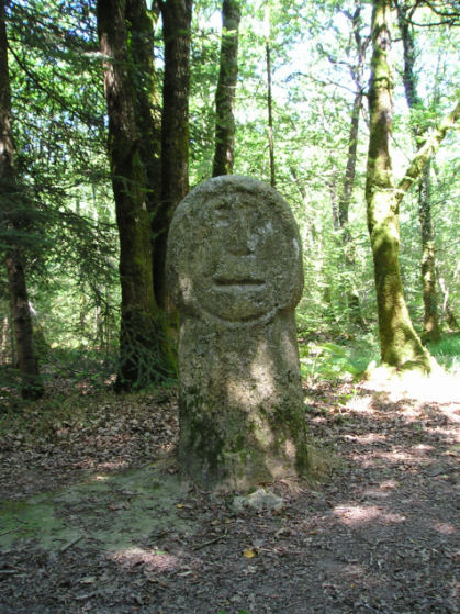
Babouin et Babouine submitted by thecaptain on 24th Aug 2005. Babouin menhir
It is not known whether the face is original, or more likely the stone was carved in more recent history.
(View photo, vote or add a comment)
Log Text: Deep in the forest to the east of Trédion can be found these two bizarre menhirs. Babouin, the baboon, is only about 1.4 metres tall, but has been resculpted at some point to have a flat front surface with a rounded shaft below a larger rounded head. On the flat face of this head has been carved a rough face within a circle, which is looking out into the forest to the south.
Babouine, the female stone, is 3.2 metres tall, slightly leaning, and has been carved into a strange three tiered cylinder shape, all the way up from ground to top. On the top section there is carved a very rough face, while on the protruding middle section a semicircular groove, perhaps a smile, or more likely the sort of necklace often seen below breasts in these ancient carvings.
It is not known how old either the original menhirs, or the recarvings are. Perhaps they are reworkings by the Gauls, or perhaps much more modern masons work. It's all a mystery, but one thing is sure, these two stones are well worth a look.
Pierres Droites (Monteneuf)
Trip No.204 Entry No.1 Date Added: 22nd Jun 2020
Site Type: Stone Row / Alignment
Country: France (Bretagne:Morbihan (56))
Visited: Yes on 9th Jul 2005. My rating: Condition 5 Ambience 5 Access 5
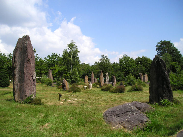
Pierres Droites (Monteneuf) submitted by thecaptain on 24th Aug 2005. A view of the wonderful Pierres Droites, in the forest near Monteneuf.
(View photo, vote or add a comment)
Log Text: The true extent of these stones was only discovered in the last 20 years or so after a forest fire, yet this set of aligned menhirs is probably one of the most important in France. A visitor centre has been set up with interactive displays which show erection of menhirs, building of neolithic homes, crop growing, archaeological excavations etc etc.
Several hundred megaliths have been found here, of which many have now been re-erected in their original socket holes. I found it quite difficult to make out any patterns to what is here, perhaps there are several lines converging, or perhaps there are circles? Many of the stones are quite big, one being over 5 metres tall and 30 tonnes in weight, yet others are little side set slabs. Most are the local schist, yet some are blocks of white quartz, moved here from a good distance away.
This place is most intriguing, and somewhere I need to find out more about.
Allée Couverte dite de Coguer Neguinan
Trip No.203 Entry No.342 Date Added: 10th May 2020
Site Type: Passage Grave
Country: France (Bretagne:Morbihan (56))
Visited: Yes on 11th Jun 2005. My rating: Condition 3 Ambience 3 Access 5
Allée couverte dite de Coguer Neguinan submitted by thecaptain on 10th May 2006. In an area on top of a hill overlooking a stream is the ancient hamlet of Le Palastre. I found quite a few stones here, but was not sure what the official dolmen is !
There are some significant looking stones built into the chapel yard wall.
(View photo, vote or add a comment)
Log Text: In an area on top of a hill overlooking a stream is the hamlet of Le Palastre, with its dolmen. I found quite a few stones here, but was not sure what the official dolmen is ! There is lots of big stones around, none of which looked too convincingly like a dolmen as opposed to natural. The best fit to the map is a series of three large boulders in a row, in the front of somebodies garden right in the centre of the hamlet. There are also some significant looking stones a bit down the hill beside the chapel yard wall. I have since learned that I dont think I found the dolmen, which is positioned somewhere behind the house.
Cohporh Menhir
Trip No.203 Entry No.341 Date Added: 10th May 2020
Site Type: Standing Stone (Menhir)
Country: France (Bretagne:Morbihan (56))
Visited: Yes on 11th Jun 2005. My rating: Condition 3 Ambience 2 Access 3
Cohporh menhir submitted by thecaptain on 11th May 2006. This poor menhir is totally enclosed by massive undergrowth, and just the top of the 3.5 metre tall stone can be seen poking its head out.
(View photo, vote or add a comment)
Log Text: This poor menhir is totally enclosed by massive undergrowth, and just the top of the 3.5 metre tall stone can be seen poking its head out. It looks to be a good one in there somewhere.
Kervengu Dolmen
Trip No.203 Entry No.343 Date Added: 10th May 2020
Site Type: Burial Chamber or Dolmen
Country: France (Bretagne:Morbihan (56))
Visited: Saw from a distance on 11th Jun 2005. My rating: Condition 3 Ambience 3
Kervengu dolmen submitted by thecaptain on 11th May 2006. This is a nice looking dolmen in the middle of a field of sweetcorn, with no obvious access to it.
(View photo, vote or add a comment)
Log Text: This is a nice looking dolmen in the middle of a field of sweetcorn, with no obvious access to it. From a distance, it looks like a single large capstone on top of three supports, but this is probably wrong. There is a tree growing beside it.
Allée couverte du Net dit Clos-et-Bé
Trip No.203 Entry No.340 Date Added: 4th May 2020
Site Type: Passage Grave
Country: France (Bretagne:Morbihan (56))
Visited: Yes on 10th Jun 2005. My rating: Condition 2 Ambience 3 Access 4
Allée couverte du Net dit Clos-et-Bé submitted by thecaptain on 13th May 2006. All that can clearly be seen is a long mound, which is completely overgrown in the middle of its field.
Closer inspection reveals there to be many stones in the mound, and at least two capstones still in position on top of an allée-couverte.
(View photo, vote or add a comment)
Log Text: Just 40 metres from the nearby menhir can be seen a long mound, but which is completely overgrown in the middle of its field, which was empty at the time of my visit. Closer inspection reveals there to be many stones in the mound, and at least two capstones still in position on top of what is a 21 metre long allée-couverte.
Menhir de Clos-et-Bé 1
Trip No.203 Entry No.339 Date Added: 4th May 2020
Site Type: Standing Stone (Menhir)
Country: France (Bretagne:Morbihan (56))
Visited: Yes on 10th Jun 2005. My rating: Condition 3 Ambience 3 Access 4
Menhir de Clos-et-Bé 1 submitted by thecaptain on 13th May 2006. This menhir which is about 3 metres tall, and just 40 metres from its neighbouring dolmen, is getting swamped by undergrowth in the middle of a field
(View photo, vote or add a comment)
Log Text: This menhir which is about 3 metres tall, and just 40 metres from its neighbouring dolmen, is getting swamped by undergrowth in the middle of a field, which was empty at the time of my visit. It has got some lovely lichens growing all over the the sparkly granite.
Saline est menhir
Trip No.203 Entry No.338 Date Added: 4th May 2020
Site Type: Standing Stone (Menhir)
Country: France (Bretagne:Morbihan (56))
Visited: Yes on 10th Jun 2005. My rating: Condition 2 Ambience 2 Access 5
Saline est menhir submitted by thecaptain on 13th May 2006. This little menhir is probably broken, and not much more than a metre in height.
It can be seen just inside somebodies front garden, but easily visible from the road.
(View photo, vote or add a comment)
Log Text: This is a little menhir, probably broken, and not much more than a metre in height, just inside somebodies front garden, but easily visible from the road.
Conguel Menhir
Trip No.203 Entry No.428 Date Added: 21st May 2020
Site Type: Standing Stone (Menhir)
Country: France (Bretagne:Morbihan (56))
Visited: Yes on 14th Jun 2005. My rating: Condition 3 Ambience 2 Access 5
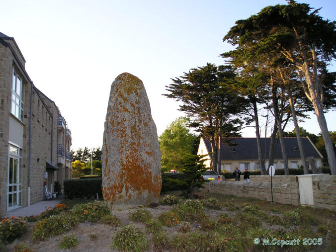
Conguel menhir submitted by thecaptain on 5th Jun 2006. This menhir, more than 4 metres tall, has been moved to its current position just outside the SNCF holiday complex from a position nearby when building work was being undertaken.
(View photo, vote or add a comment)
Log Text: This menhir, about 3 metres tall, has been moved to its current position just outside the SNCF holiday complex from a position nearby when building work was being undertaken. It now serves as a sort of garden feature, and is easily seen from the road.
