Contributory members are able to log private notes and comments about each site
Sites theCAptain has logged. View this log as a table or view the most recent logs from everyone
Roche d'Arthur
Trip No.204 Entry No.219 Date Added: 4th Sep 2020
Site Type: Standing Stone (Menhir)
Country: France (Bourgogne:Côte-d'Or (21))
Visited: Couldn't find on 4th Aug 2005
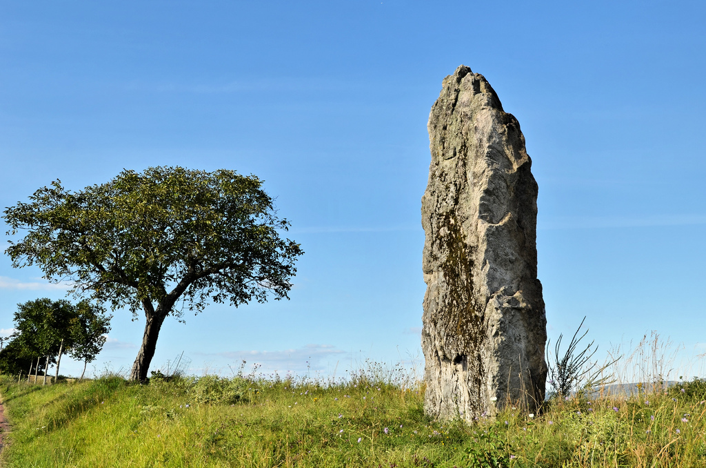
Roche D'arthur submitted by AlexHunger on 11th Jul 2010. Unusual Stone in Bourgogne. I have classed it as a Menhir, but it is probably a natural stone that has been arranged near the top of a hill in what is now a hiking area. A local web site believes it was and probably is still being used in fertility rites. A woman sliding down the stone was assured of hightened fertility.
(View photo, vote or add a comment)
Log Text: The village of Roche-en-Brenil is supposed to have two menhirs, but I could find no sign of either of them. It's a shame that these places do not have village maps with things marked, or any signposts like they do elsewhere. The area is covered with forests, and looks to be lots of natural granite outcrops.
Grottes d'Arcy-sur-Cure
Trip No.204 Entry No.220 Date Added: 4th Sep 2020
Site Type: Cave or Rock Shelter
Country: France (Bourgogne:Yonne (89))
Visited: Saw from a distance on 4th Aug 2005

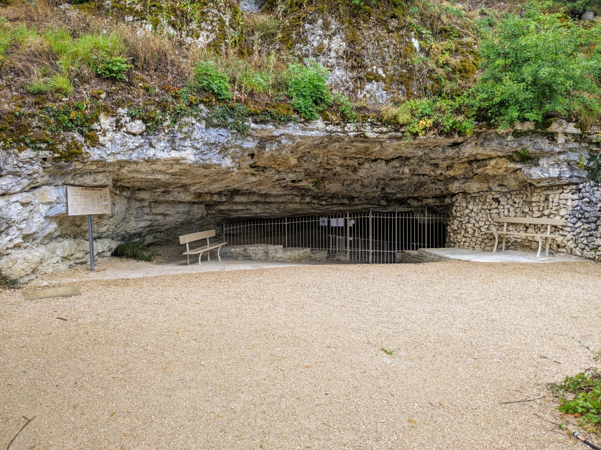
Grottes d'Arcy-sur-Cure submitted by aolson on 24th Jul 2020. The entrance to the Great Cave, the only one open to the public.
(View photo, vote or add a comment)
Log Text: I drove past these caves, without realising what significance they have. If I had realised, I would have visited.
Pierre-Fritte (Villeneuve-sur-Yonne)
Trip No.204 Entry No.221 Date Added: 4th Sep 2020
Site Type: Standing Stone (Menhir)
Country: France (Bourgogne:Yonne (89))
Visited: Couldn't find on 4th Aug 2005
Log Text: I could find nowhere to stop and look for this menhir, which is somewhere between the busy N.6 road and the river Yonne.
Dolmen de la Bourde à la Gousse
Trip No.204 Entry No.224 Date Added: 4th Sep 2020
Site Type: Burial Chamber or Dolmen
Country: France (Bourgogne:Yonne (89))
Visited: Couldn't find on 4th Aug 2005
Log Text: There is a dolmen marked on my ign map near to the village of La Bourde a la Gousse, so I went to have a look. I walked a fair distance down a forest track, but I could find nothing. The forest was either very dense and impenetrable, or fenced off. There was at one point lots of rocks on the forest floor, in about the right position, but these were in a fenced off enclosure.
Pierre Guénachère
Trip No.204 Entry No.203 Date Added: 27th Aug 2020
Site Type: Sculptured Stone
Country: France (Bourgogne:Saône-et-Loire (71))
Visited: Yes on 3rd Aug 2005. My rating: Condition 3 Ambience 4 Access 4
Pierre Guénachère submitted by thecaptain on 5th Sep 2006. Pierre Guénachère is a large granite block deep in the forest, which has got several strange carvings in it, and it is thought that they are prehistoric.
On the north side there are three circles, between 70 cm and 1 metre in diameter.
(View photo, vote or add a comment)
Log Text: This is a large granite blockdeep in the forest near a little stream, about one kilometres walk from the farm of La Madeleine, just to the west of St Emiland. Take the track beside the farm, keeping left, and after some distance it is signposted.
The stone is a granite block, 4m by 3m by 2m high, which has got several strange carvings in it, particularly large circles. On the north side there are three circles, between 70 cm and 1 metre in diameter, while on the south side there is a straight line and a large, deeply cut circle, more than one metre in diameter. These symbols seem to have been very roughly hewn with stone tools, and it is thought that they are prehistoric. There are many legends associated with this stone, of which I don't know any.
Dolmen dit la Pierre-Brûlée
Trip No.204 Entry No.212 Date Added: 27th Aug 2020
Site Type: Burial Chamber or Dolmen
Country: France (Bourgogne:Côte-d'Or (21))
Visited: Yes on 3rd Aug 2005. My rating: Condition 3 Ambience 3 Access 3
Dolmen dit la Pierre-Brûlée submitted by thecaptain on 16th Sep 2006. La Pierre-Brûlée, Volnay.
Just to the south of the D.17 between Meloisey and Pommard, the remains of a mound can be seen, with a capstone sitting on the top.
(View photo, vote or add a comment)
Log Text: Just to the south of the D.17 between Meloisey and Pommard, near to the crossroads with the D.23, this dolmen is to be found within a field which when I visited was well fenced off with electric fencing and full of sheep, so I didn’t go in. The remains of a mound can be seen, with a capstone sitting on the top.
La Pierre qui Vire (Rochepot)
Trip No.204 Entry No.208 Date Added: 27th Aug 2020
Site Type: Burial Chamber or Dolmen
Country: France (Bourgogne:Côte-d'Or (21))
Visited: Yes on 3rd Aug 2005. My rating: Condition 2 Ambience 3 Access 4
La Pierre qui Vire (Rochepot) submitted by thecaptain on 16th Sep 2006. There's not much left to see, except the big capstone which is sort of triangular shaped.
There are traces of a mound, and a chamber underneath, but nothing really substantial remains.
(View photo, vote or add a comment)
Log Text: High up on the ridge to the south of the village of Rochepot, with its fantastic chateau and well known wines, can be found this stone which turns. There's not much left to see, except the big capstone which is sort of triangular shaped, 4 metres by 3 metres. There are traces of a mound, and a chamber underneath, but nothing really substantial remains.
There are supposedly several dolmens and an allee couverte in the Rochepot community, but if this is the only one on the maps, I doubt I will find any of the others, so decide to give up now on looking for more.
Menhirs d'Epoigny
Trip No.204 Entry No.204 Date Added: 27th Aug 2020
Site Type: Standing Stones
Country: France (Bourgogne:Saône-et-Loire (71))
Visited: Yes on 3rd Aug 2005. My rating: Condition 5 Ambience 5 Access 5
Menhirs d'Epoigny submitted by thecaptain on 27th Oct 2006. Just outside the main field of stones, beside the road junction, is a sixth menhir, this one only about 2 metres tall and broken, and which does not align with any of the others. Another stone is nearby.
This is the first view you get of the stones as you approach.
(View photo, vote or add a comment)
Log Text: Just to the south of the D.978 road, a few kilometres north west of Couches, is a sign to menhirs, which I of course followed. About a kilometre from the main road is a little road junction, and several menhirs can be seen in the fields. It's hard to make out exactly what the menhirs represent, and how accurate they are is open to question, as they have all been re-erected in concrete bases fairly recently.
Near the side of the lane is a row of three superbly sculpted menhirs, the southern one being 5.5 metres tall, with several carved lines and cupmarks. The central menhir is about 4.5 metres tall, but has lost its top, while the northern menhir is fallen and broken (in actual fact it looks to have been cut up) and would perhaps have been bigger than its neighbours. The three menhirs are evenly spaced about 7 metres apart, and are aligned NW to SE at about 125°. Forty or fifty metres away to the north, are another pair of menhirs, both about 4.5 metres in height, and again they are superbly shaped and dressed. These are spaced at about 10 metres from each other, and align NE to SW at 025°, and any intersection passes through the row of three but not at any stone. Of this pair of menhirs, the southern one has a few cupules carved into it, while the northern one is decorated with lines, cupules and at least one axe, and a few more serpent like lines. Just outside this field, beside the road junction, is a sixth menhir, this one only about 2 metres tall and broken, and which does not align with any of the others.
It is thought that there was once more menhirs here. This feels like a very powerful place, up on this hill. I feel all trembly here, and in awe of the stones, and find it hard to leave.
Mont-de-Sène dolmen 1
Trip No.204 Entry No.207 Date Added: 27th Aug 2020
Site Type: Burial Chamber or Dolmen
Country: France (Bourgogne:Saône-et-Loire (71))
Visited: Couldn't find on 3rd Aug 2005
Log Text: Remains of at least three dolmens and their mounds are to be found on the slopes of Mont-de-Sène, high up above the village of Dezize-les-Maranges.
Allée Couverte de la Chaume
Trip No.204 Entry No.209 Date Added: 27th Aug 2020
Site Type: Passage Grave
Country: France (Bourgogne:Côte-d'Or (21))
Visited: Couldn't find on 3rd Aug 2005
Log Text: There are supposedly several dolmens and an allee couverte in the Rochepot community, but not marked on my maps, I doubt I will find any of the others, so soon decided to give up now on looking for more.
Chateillon
Trip No.204 Entry No.210 Date Added: 27th Aug 2020
Site Type: Passage Grave
Country: France (Bourgogne:Côte-d'Or (21))
Visited: Couldn't find on 3rd Aug 2005
Log Text: Remains of an Allée Couverte and its mound are to be found on a west facing slope near to the village of La Rochepot. I could find nothing obvious on maps to find.
La Garenne (La Rochepot)
Trip No.204 Entry No.211 Date Added: 27th Aug 2020
Site Type: Burial Chamber or Dolmen
Country: France (Bourgogne:Côte-d'Or (21))
Visited: Couldn't find on 3rd Aug 2005
Log Text: Dolmen to be found in the commune of La Rochepot, Côte-d'Or, but I could find nothing on maps to find it
Dolmen de Pierrefitte (Volnay)
Trip No.204 Entry No.213 Date Added: 27th Aug 2020
Site Type: Burial Chamber or Dolmen
Country: France (Bourgogne:Côte-d'Or (21))
Visited: Couldn't find on 3rd Aug 2005
Log Text: Dolmen in tumulus to be found in the commune of Volnay. This dolmen was excavated in 1914, yielding several bones. I could find nothing obvious to lead me here.
Croconnet Tumulus
Trip No.204 Entry No.214 Date Added: 27th Aug 2020
Site Type: Chambered Cairn
Country: France (Bourgogne:Côte-d'Or (21))
Visited: Couldn't find on 3rd Aug 2005
Log Text: I had a need to fill up with diesel, and so couldn’t spend long looking for this, having spent about an hour driving round every lane in the area trying to find it. I am wondering if there is a local law around here prohibiting any roadsigns for anything other than wine sellers. The tumulus wasn't to be obviously found up the trackway I walked up.
Tombeaux du Single
Trip No.204 Entry No.215 Date Added: 27th Aug 2020
Site Type: Burial Chamber or Dolmen
Country: France (Bourgogne:Côte-d'Or (21))
Visited: Couldn't find on 3rd Aug 2005
Log Text: As with so many of the megalithic sites in the area, I could find nothing to help me find it. Remains of two burial chambers made with large slabs were excavated here in 1867. Many human bones, flint tools and a round holed stone were found.
Pierre-aux-Fées (St-Micaud)
Trip No.204 Entry No.202 Date Added: 26th Aug 2020
Site Type: Standing Stone (Menhir)
Country: France (Bourgogne:Saône-et-Loire (71))
Visited: Yes on 2nd Aug 2005. My rating: Condition 4 Ambience 3 Access 5
Pierre-aux-Fées (St-Micaud) submitted by thecaptain on 5th Sep 2006. The Pierre-aux-Fées is about 7 metres tall, and has perhaps got some carvings on it.
(View photo, vote or add a comment)
Log Text: This is a very large menhir right beside the D.28 road in front of a large house in the village of St-Micaud. I would estimate it to be about 7 metres tall, but its not easy to tell as it is in the private garden and surrounded by a hedge. The menhir is of rectangular shape, nd has very uneven surfaces, and has perhaps got some carvings on it.
Pierre-Levée du champ de la Fa
Trip No.204 Entry No.200 Date Added: 26th Aug 2020
Site Type: Standing Stone (Menhir)
Country: France (Bourgogne:Saône-et-Loire (71))
Visited: Yes on 2nd Aug 2005. My rating: Condition 4 Ambience 4 Access 4
Pierre-Levée du champ de la Fa submitted by thecaptain on 5th Sep 2006. Near to the medieval village of Brancion, can be found this 4 metres tall menhir with a cross on the top.
(View photo, vote or add a comment)
Log Text: Near to the medieval village of Brancion, beside the D.14 road, can be found this nice menhir, which has a fine view to the west. It stands about 4 metres tall with a cross on the top in a field close to the turn off to Pierre-Levée farm, on a bad corner. It was raining horribly while I visited.
Menhir d'Uxelles
Trip No.204 Entry No.201 Date Added: 26th Aug 2020
Site Type: Standing Stone (Menhir)
Country: France (Bourgogne:Saône-et-Loire (71))
Visited: Couldn't find on 2nd Aug 2005

Menhir d'Uxelles submitted by TheCaptain on 12th Apr 2016. Menhir d'Uxelles - Saône et Loire Image copyright: Vaxjo, hosted on Flickr and displayed under the terms of their API.
(View photo, vote or add a comment)
Log Text: I see in my notes that there is a menhir to be found in the commune of Uxelles, but there is nothing to be found on any of my maps, and I could find no signposts to it or reference to it on any of the village signs.
Dolmen de Saint-Michel d'Aiguilhe
Trip No.204 Entry No.197 Date Added: 24th Aug 2020
Site Type: Burial Chamber or Dolmen
Country: France (Auvergne:Haute-Loire (43))
Visited: Yes on 28th Jul 2005. My rating: Condition -1 Ambience 5 Access 3
Dolmen de Saint-Michel d'Aiguilhe submitted by TheCaptain on 27th Aug 2020. The 11th century Chapel Saint-Michel d'Aiguilhe is built on the top of the volcanic Aighuille. But it is built on top of the site of a previous chapel, which was said to have been built on top of a dolmen. Three stones from this dolmen are said to be incorporated into the chapel.
(View photo, vote or add a comment)
Log Text: The 11th century Chapel St Michel is built on the ridiculously pointed site of the volcanic Aighuille. But it is built on top of the site of a previous chapel, which was said to have been built on top of a dolmen, or some other megalithic structure.
La Pierre-des-Fievres
Trip No.204 Entry No.198 Date Added: 24th Aug 2020
Site Type: Burial Chamber or Dolmen
Country: France (Auvergne:Haute-Loire (43))
Visited: Yes on 28th Jul 2005. My rating: Condition 1 Access 4

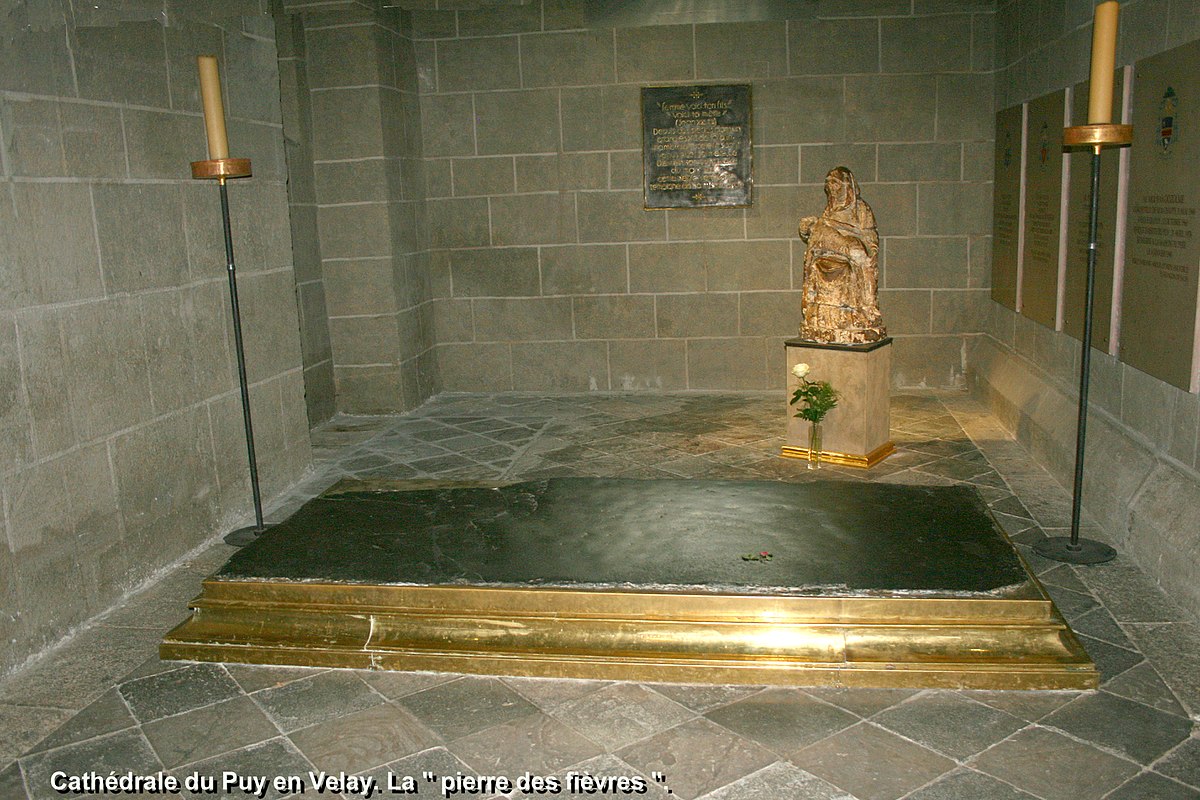
La Pierre-des-Fievres submitted by TheCaptain on 26th Aug 2020. La Pierre-des-Fievres in the Cathedral of Puy-en-Velay
Pic from wikimedia commons
(View photo, vote or add a comment)
Log Text: The Cathedral of Puy-en-Velay is said to be built on the site of an ancient dolmen, part of which is still in existance as La Pierre des Fievres which is kept and presented near to one of the entrances. It is said that this stone is a part of the coverstone for the dolmen which stood in this sacred place for thousands of years before the coming of Christianity. It is believed that the dolmen was complete until the 9th century, when it was broken by a bolt of lightning, but that the Pilgrims to this place ensured that a part of it was kept here. The stone is highly venerated, and many miracles are attributed to it, including many which involve curing fever, after which it is named. For many years the stone was kept within the Cathedral, but then was put in a place outside so that ill people could have easier access to touch it. To this day, the Cathedral and a dolmen are a symbol of this town of Pilgrimmage, which is an important stopping place on the way of St James.
