Contributory members are able to log private notes and comments about each site
Sites theCAptain has logged. View this log as a table or view the most recent logs from everyone
Trémarche menhir
Trip No.193 Entry No.19 Date Added: 13th Jul 2020
Site Type: Standing Stone (Menhir)
Country: France (Bretagne:Côtes-D'Armor (22))
Visited: Yes on 30th May 1993
Trémarche menhir submitted by thecaptain on 27th Feb 2007. 3 m tall menhir set into a little gravel area at the side of the D.11 road beside the junction at Trémarche, a few kilometres to the south of Trégastel.
(View photo, vote or add a comment)
Log Text: Cycling camping trip of north Brittany, day 2. Tregastel, Ile Grande, Tel Star Satellite place. Snake! Lots of ancient stones. All getting tired now, but it should be mostly downhill back to the campsite.
Toul an Lann menhir
Trip No.193 Entry No.21 Date Added: 13th Jul 2020
Site Type: Standing Stone (Menhir)
Country: France (Bretagne:Côtes-D'Armor (22))
Visited: Saw from a distance on 31st May 1993

Toul an Lann menhir submitted by Martin_L on 31st Jan 2009. Toul-al-Lann Menhir.
Situated in a field right North of the Lannion Saint-Michel-en-Grève road (D 786). This fine Menhir is appr. 4m tall, an has a slender shape.
(May 2001)
(View photo, vote or add a comment)
Log Text: Cycling camping trip of north Brittany, day 3. Breton Corniche, Treburden, Lannion, Corniche Armorique to Primel Tregastel. Ace dinner at Diben.
Oratoire de St Guirec
Trip No.214 Entry No.19 Date Added: 23rd Jul 2020
Site Type: Ancient Temple
Country: France (Bretagne:Côtes-D'Armor (22))
Visited: Yes on 17th Apr 2014. My rating: Condition 3 Ambience 4 Access 4
Oratoire de St Guirec submitted by TheCaptain on 21st Jul 2020. Site in Bretagne:Côtes-D'Armor (22) France
The Oratoire de St Guirec on the beach named after St Guirec, the Welsh monk who allegedly landed here on his voyage from Britain in the 6th century, arriving in a stone trough pulled by angels.
(View photo, vote or add a comment)
Log Text: Morning in Ploumenach with Dad, and take the time to walk all around the pink granite coast. It is superb in the morning sun. The Oratoire de St Guirec is situated on the beach named after St Guirec, the Welsh monk who landed here on his voyage from Britain in the 6th century, allegedly arriving in a stone trough pulled by angels. The original wooden statue has been replaced by one of stone, after becoming damaged by the local tradition for girls to stick a pin in its nose when they wanted to marry.
Trémarche menhir
Trip No.214 Entry No.17 Date Added: 23rd Jul 2020
Site Type: Standing Stone (Menhir)
Country: France (Bretagne:Côtes-D'Armor (22))
Visited: Yes on 16th Apr 2014. My rating: Access 5
Trémarche menhir submitted by thecaptain on 27th Feb 2007. 3 m tall menhir set into a little gravel area at the side of the D.11 road beside the junction at Trémarche, a few kilometres to the south of Trégastel.
(View photo, vote or add a comment)
Log Text: Passed by in a front garden on the way to Ploumanach
Toul an Lann menhir
Trip No.214 Entry No.15 Date Added: 23rd Jul 2020
Site Type: Standing Stone (Menhir)
Country: France (Bretagne:Côtes-D'Armor (22))
Visited: Yes on 16th Apr 2014. My rating: Condition 4 Ambience 3 Access 5

Toul an Lann menhir submitted by Martin_L on 31st Jan 2009. Toul-al-Lann Menhir.
Situated in a field right North of the Lannion Saint-Michel-en-Grève road (D 786). This fine Menhir is appr. 4m tall, an has a slender shape.
(May 2001)
(View photo, vote or add a comment)
Log Text: A nice slender four metre tall menhir in a field just to the north of the busy D.786 just north of Lannion.
Lann Ar Peulven menhir
Trip No.214 Entry No.16 Date Added: 23rd Jul 2020
Site Type: Standing Stone (Menhir)
Country: France (Bretagne:Côtes-D'Armor (22))
Visited: Couldn't find on 16th Apr 2014

Lann Ar Peulven menhir submitted by FelixBerger on 28th Aug 2017. Well hidden in the woods - this site is not easily accessible, there are thorny shrubs and ticks around, and no path. It is an enchanted place, make sure to not disturb it.
(View photo, vote or add a comment)
Log Text: A five metre tall menhir which should be found in the forest to the west of the D.88 to the north of Lannion, however I could not find a way to get to it.
Rochers de Ploumanac'h
Trip No.214 Entry No.18 Date Added: 23rd Jul 2020
Site Type: Natural Stone / Erratic / Other Natural Feature
Country: France (Bretagne:Côtes-D'Armor (22))
Visited: Yes on 17th Apr 2014. My rating: Ambience 4 Access 4

Rochers de Ploumanac'h submitted by TheCaptain on 29th Jun 2020. Whale or pouring bottle?
(View photo, vote or add a comment)
Log Text: Morning in Ploumenach with Dad, and take the time to walk all around the pink granite coast. It is superb in the morning sun. The headland north of Ploumanac'h is now a municipal park, and has the most spectacular coastline where the pink granite rocks tumble into the emerald blue sea. This headland abounds in strangely shaped rocks, many with names such as the tortoise, the witch, the Egyptian and a bottle. There is a beautiful signed footpath which runs all around this headland from the beach where the Oratoire de St Guirec is positioned, marking the place where the Welsh monk landed after his voyage from Britain in the 6th century, allegedly arriving in a stone trough pulled by angels.
Barnenez Cairn
Trip No.203 Entry No.539 Date Added: 29th May 2020
Site Type: Chambered Cairn
Country: France (Bretagne:Finistère (29))
Visited: Yes on 22nd Jun 2005. My rating: Condition 5 Ambience 3 Access 4
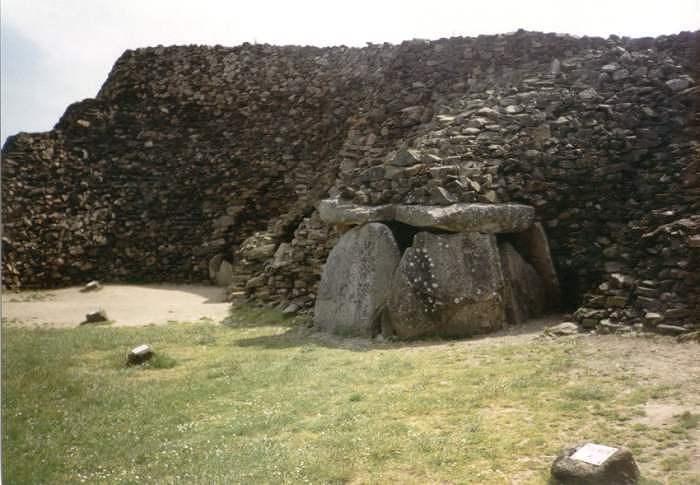
Barnenez Cairn submitted by thecaptain on 17th Oct 2004. Barnenez Cairn.
View of the quarried away bit of the northwestern side, showing the remains of one of the central chambers.
When the workmen found these internal structures in 1955, the thankfully stopped taking the stone away to make roads, and we are thankfully left with the majority of this wonderful tomb still here after 6500 years.
(View photo, vote or add a comment)
Log Text: This magnificent large cairn, is now signposted from miles around as Le Grand Cairn (de Barnenez). It costs €4.60 to get in, and there is a little visitor centre and shop, with replicas of some of the carved stones on display. Unlike 12 years ago, or whenever, you cannot go into many of the chambers, which are now walled off fairly crudely and unimaginatively, which I think really spoils the place. Its not just that you cant get in, but the way its been done really detracts from the view of the cairn and all its many entrances.
Only two chambers and passages are now open, these being the two beehive construction open chambers, but these seem to be cracking and breaking up. I was told by the man in the centre that they are not, and that they have been like that since their discovery. Perhaps its my memory, but I wonder if the 1960s restoration work is not lasting anywhere near so long as the original 6,000 year old work!
It's still a mighty impressive and imposing tomb sitting on top of its headland, and I think that more land has been cleared around it, allowing much better views over the Bay of Morlaix on one side, and Anse de Terenez on the other, which during this visit were full with a high tide, making the whole place seem truly wonderful.
I got talking to the men in the shop, and they were interested to hear about what I was doing, and one of the guys suggested a couple of places that I shouldn't miss. Commana allee couverte near Roche Trevezel, and Chapelle des Sept Saints near Lannion - a chapel built on top of a dolmen, which can still be seen.
Lagatjar alignements
Trip No.203 Entry No.498 Date Added: 27th May 2020
Site Type: Stone Row / Alignment
Country: France (Bretagne:Finistère (29))
Visited: Yes on 19th Jun 2005. My rating: Condition 4 Ambience 4 Access 5
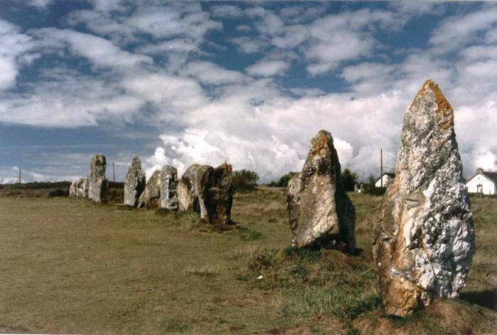
Lagatjar Alignements submitted by thecaptain on 18th Oct 2004. Lagatjar Alignements.
West of the fishing town of Camaret, in the far west of the Crozon Peninsula, Finisterre Brittany.
If memory serves me right, these stones form part of a sort of large stone square.
(View photo, vote or add a comment)
Log Text: The Lagatjar alignements are an intriguing arrangement of stones, mostly consisting of large white quartz blocks on open common land, just to the east of the fishing town of Camaret. There are probably over a hundred stones, mostly aligned into three lines, but there are some outliers as well.
The longest line is over 200 metres in length and has an orientation of 037°. From this line are two rows of larger blocks, heading off at right angles on bearing 317° for the northern row, which is approximately straight and 60 metres in length. The southern row is about 50 metres away, and heads off at 315°, but curves towards the west away from the baseline. Perhaps these two rows once joined up to form a horseshoe ?
South of the main line are three large grey stones, a single one at the west and a pair to the east. These three stones are aligned with each other. There are lots of orchids flowering here, which seems a bit late in the year.
St-Guinec menhir
Trip No.203 Entry No.548 Date Added: 2nd Jun 2020
Site Type: Standing Stone (Menhir)
Country: France (Bretagne:Finistère (29))
Visited: Yes on 23rd Jun 2005. My rating: Condition 5 Ambience 3 Access 4
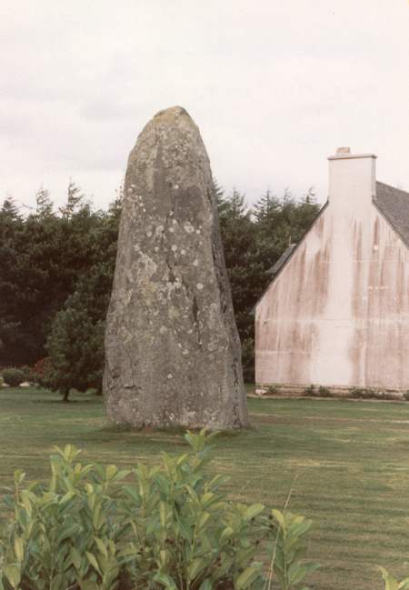
St-Guinec menhir submitted by thecaptain on 29th Oct 2004. Menhir Saint-Guinec.
A massive menhir standing in the garden of a house a couple of kilometres west of the village of Huelgoat in Brittany
(View photo, vote or add a comment)
Log Text: Despite being nearly 6 metres tall, this beautiful menhir is becoming obscured from view by a large thick hedge around the garden within which it stands. This is a shame, as it really is a rather nice stone. It can be found just off the Huelgoat to Brennilis road, by the bridge over the busy north / south D.764 highway.
Ty ar Boudiquet Dolmen
Trip No.203 Entry No.545 Date Added: 2nd Jun 2020
Site Type: Burial Chamber or Dolmen
Country: France (Bretagne:Finistère (29))
Visited: Yes on 23rd Jun 2005. My rating: Condition 5 Ambience 4 Access 5
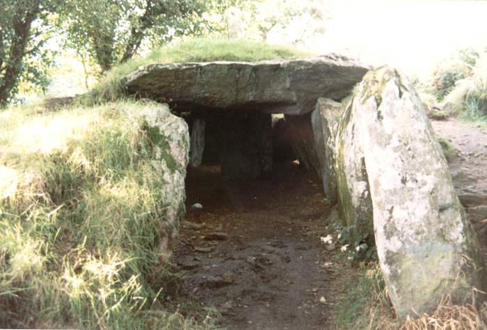
Ty ar Boudiquet dolmen submitted by thecaptain on 29th Oct 2004. Brennilis Dolmen, an Allee Couvert still partially buried under its mound.
Found just outside the small village of Brennilis, about halfway between Brasparts and Huelgoat in western Brittany
(View photo, vote or add a comment)
Log Text: What a lovely monument this is! It's one of my favourites. It is easy to find, just at the northern edge of Brennilis village and clearly signposted, it has a little car park, a picnic area and it lives in a lovely large green and shady area, all very nicely looked after and with birdies tweeting away.
It is a rare dolmen in V form, which is thought to be a transitional stage between dolmens with entry passages (dolmen a couloir) and allée couvertes. It has been dated to about 3000BC.
It is almost complete, and has most of its earthern mound still with it, only a part of the back end has been destroyed by having a wall built through it. The chamber is about 14 metres long and varies in width from about 1 metre wide at the entrance, to nearly 3 metres at full width. The height also varies from about a metre to stand up height. The chamber opens at 125°. The main part of the is covered with three massive capstones, and has within it a standing stone which does not quite reach the roof. Perhaps a stele, but not smoothed and sculpted, or perhaps the remains of an internal wall.
Outside the chamber, the mound is almost complete, and even comes with most of its surrounding peristalith of stones. It is of an oval shape, approximately 17 metres long by 6 metres wide, and still up to 3 metres in height. Unfortunately the back end is cut by a wall and field boundary. The fairies house really is just that. A beautiful place for the little people to live.
Croazou chapel
Trip No.203 Entry No.524 Date Added: 28th May 2020
Site Type: Ancient Cross
Country: France (Bretagne:Finistère (29))
Visited: Yes on 21st Jun 2005. My rating: Condition 3 Ambience 3 Access 5
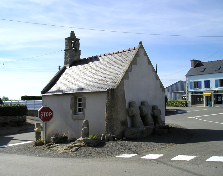
Croazou chapel submitted by thecaptain on 3rd Jul 2005. The little chapel at Croazou in its modern road junction.
The cornerstone is an Iron Age Stele, and the three medieval crosses by the back wall are sitting on a fallen menhir.
How much more continuity of somewhere being a sacred place can you get.
(View photo, vote or add a comment)
Log Text: This is an odd little place where many thousands of years of ritual and worship can all be seen together. In the middle of a fairly busy road junction is built a little chapel which is said to be the smallest in Finistère. This chapel has been built onto a stèle with it still standing there at one of the back corners about 2 metres tall.
Outside the back wall are three medieval crosses positioned on top of a fallen menhir supposedly in all being in their original positions. Around the outside of the chapel is also a fairly recent collection of other crosses from the region which includes one intriguing cross which has been mounted on the top portion of what was obviously once a lovely iron age stele with wonderful shaping and patterns carved into it.
Trouble is while I was there it must have been going home time and the junction was very busy and stopping and getting pictures was very difficult having enough time to stand in the road and get a photo without getting run down.
Men-Marz
Trip No.203 Entry No.527 Date Added: 28th May 2020
Site Type: Standing Stone (Menhir)
Country: France (Bretagne:Finistère (29))
Visited: Yes on 21st Jun 2005. My rating: Condition 5 Ambience 4 Access 5
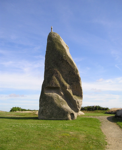
Men-Marz submitted by thecaptain on 3rd Jul 2005. Men-Marz (the Miracle Stone) seen from the north side in all its 8.5 metre glory.
(View photo, vote or add a comment)
Log Text: What a wonderful and fantastic menhir this is easily found to the north of Brignogan-Plage village by following plentiful signs. Men-Marz (the Miracle Stone in Breton) or Men-Bras (Grand Stone) is now set in a nice little area a previously close built house having been bought and demolished by the state and has a good information centre across the road with lots of informative boards.
At between 8.2 and 8.5 metres high depending upon where it is measured on the sloping ground it is said to be the fourth largest menhir still standing in France. It is a strange shaped beast as are the natural rocks around here and looks to be a thin and straight beast when seen from front and back but is a sort of triangular shape when seen from the sides with multiple cavities and ledges in the sides.
The stone has suffered from Christianising vandalism on at least two occasions as it not only has a granite cross mounted on the top but there is also an engraved cross on the south-eastern corner about 1.5 metres from the ground.
This stone has many legends attached to it which seem to get a bit mixed up and confused. There is a fairly flat ledge high up on the south side with several loose stones sitting on it. There seems to be two stories attached to this and the habit of throwing up pebbles onto it. One of the stories has it that young girls wanting to get married go to the stone and throw up a pebble. If the stone lands on the ledge and doesn’t fall down then she will be married within the year. This story is also told in a slightly different form in that young newly wed couples go to the stone and throw up a pebble and if the pebble lands and stays on the ledge then they will have an heir before the year is out. One throw only obviously. To this day newly wed couples come to this stone straight after the service.
While there I took my chances and threw a stone up and it did indeed stay up on the ledge. I do not know what this now has in store for me !
Guinivrit
Trip No.203 Entry No.529 Date Added: 28th May 2020
Site Type: Passage Grave
Country: France (Bretagne:Finistère (29))
Visited: Yes on 21st Jun 2005. My rating: Condition 3 Ambience 4 Access 4
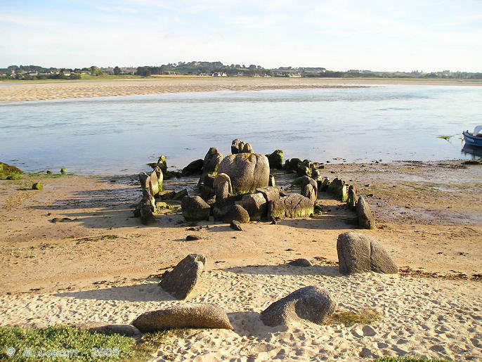
Guinivrit submitted by thecaptain on 25th Mar 2006. Guinivrit allée couverte.
The remains of this allée couverte clearly show the rise in sea level over the past 4000 odd years. Twice a day it gets a wash.
(View photo, vote or add a comment)
Log Text: This really is a nice place to visit, certainly when its quiet and the sun is out. I had hoped to see it with the tide well in tonight, but one thing and another and its now gone 8:00, and the tide is already gone out for two hours, and the water has gone from around it. However, there is still a lot of water flooding out of the bay, and I certainly wouldn't want to try and get a boat in here, as its going at running speed.
The allée couverte is easily found down beside the little harbour, and nowadays is signposted. Its not far at all from the little campsite where I stayed. Despite the fact that it has no capstones, and that some of the large side stones have been broken so it could act as a mole in the water for mooring and protecting boats in the past, it really is surprisingly complete. Most of the stones are still in place, not only of the main chamber, but also the peristalith, which is suitably boat shaped. In fact the whole thing looks rather like a boat pulled up onto the shoreline.
The main chamber is about eleven metres long and 1.5 metres in width, but with the outer stones the full size of the monument is more than double that, perhaps 30 metres by 6 metres. There is both a forward and aft extension to the compartmentalised chamber. Fantastic.
While here, I met a chap out for a bike ride, and we got talking about why I was here and ancient stones. He said he has always lived in the area, and as a boy used to play in the Goazvenn dolmen. He went on to tell me about a large fallen menhir that is almost forgotten, and that nobody ever talks about, and which seems to be in no historical records. He told me how to find it by walking around the coast path, and showed me where it was on my map, fallen onto the rocky shore. I decided that this was one place I had to visit, finding these forgotten stones has much more of a thrill than seeing the well known ones.
Grand menhir de Saint-Eden
Trip No.203 Entry No.532 Date Added: 28th May 2020
Site Type: Standing Stone (Menhir)
Country: France (Bretagne:Finistère (29))
Visited: Yes on 22nd Jun 2005. My rating: Condition 2 Ambience 3 Access 3

Grand menhir de Saint-Eden submitted by thecaptain on 20th May 2006. Laying fallen at the edge of the sea is the almost forgotten St Eden grand menhir.
(View photo, vote or add a comment)
Log Text: This is the menhir that the chap I met last night was telling me about, right at the edge of the Grève (rocky shore), and unfortunately the sea has claimed it. It is now fallen and laying top down into the sea when the tide is in. Perhaps its one of those menhirs that came down to the sea to drink at midnight, had too much and didnt make it back. Or perhaps came down one night when the tide was not a big one, and fell over while trying to quench its thirst. Whatever, its a great pleasure to find this almost forgotten stone which is not marked on any map.
The stone is a lovely top heavy shape, some would say phallic, and about 8 metres in length. Its a pity it cant be re-erected somewhere, although obviously not in its original cliff edge position. There was an old farmer chap working in some fields nearby who told me that he could remember it standing, but he had no idea when it fell, but it was a long time ago. Fantastic.
Île Carn cairn
Trip No.203 Entry No.514 Date Added: 27th May 2020
Site Type: Chambered Cairn
Country: France (Bretagne:Finistère (29))
Visited: Saw from a distance on 20th Jun 2005. My rating: Access 2
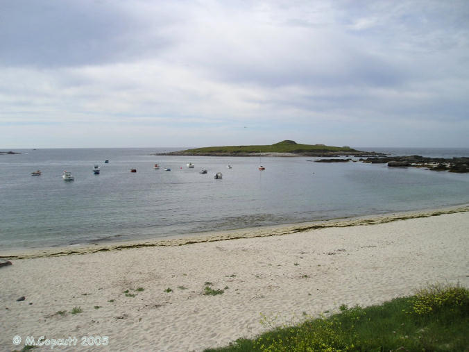
Île Carn cairn submitted by thecaptain on 15th Jun 2006. Île Carn, just off the northwestern coast of Brittany.
Unfortunately, when I was passing here the tide was not fully out, and rising, so I could not get out onto the little island with its massive and spectacular cairn.
I tried stopping nearby for the night, which would have let me get out onto the island next morning, but the local campsite was closed and deserted, and I had worldly needs, so had to move on elsewhere, still hoping to come back the next morning.......
(View photo, vote or add a comment)
Log Text: Just offshore is this little island which can be reached a low tide, with a massive cairn containing three dolmenic chambers. There are also some WW2 gun emplacements and lookouts which spoil it a bit. The cairn is massive, and looks like its been quarried into, and from the shore the entry to one of the chambers can be seen. Its a pity I cannot get out to have a look. Should I borrow a boat ?
Île Tariec cairn
Trip No.203 Entry No.518 Date Added: 28th May 2020
Site Type: Cairn
Country: France (Bretagne:Finistère (29))
Visited: Yes on 21st Jun 2005. My rating: Condition 2 Ambience 5 Access 2
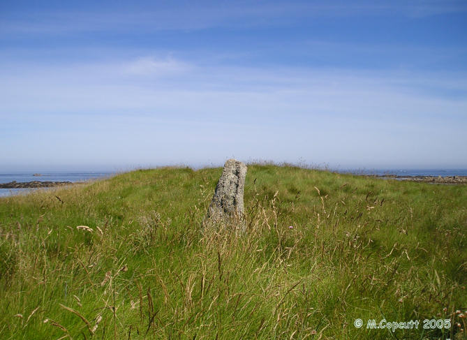
Île Tariec cairn submitted by thecaptain on 20th Jun 2006. On the seaward part of the island are the remains of a chambered cairn and a small menhir.
(View photo, vote or add a comment)
Log Text: Just to the north of the menhir on this little island which can be reached at low tide, is the slight mound of a cairn. Its about 15 metres in diameter and 2 metres in height. I could see nothing in the way of structure under all the grass and stuff.
Ile Guénioc
Trip No.203 Entry No.519 Date Added: 28th May 2020
Site Type: Chambered Tomb
Country: France (Bretagne:Finistère (29))
Visited: Saw from a distance on 21st Jun 2005. My rating: Condition 5 Ambience 5 Access 1

Ile Guénioc submitted by thecaptain on 17th Jun 2006. This island, which is difficult to get to, has on it three massive cairns with their multitude of chambers and dolmens within them.
This is the best picture I could get on my little camera, taken on full zoom from Ile Tariec, which can be walked to at very low tide.
(View photo, vote or add a comment)
Log Text: Just offshore from Presqu'ile Ste-Marguerite near the town of Landéda, and due west of Ile Tariec, can be seen Ile Guénioc (Ile Gaignog). This island, which is difficult to get to, has on it three massive cairns with their multitude of chambers and dolmens within them. In order to get here a boat is needed, and I think that landing on the island is controlled, so I am not going to manage it now, as there is nobody about with a boat who I can try and persuade!
Through my binoculars from where I am sat on Ile Tariec it looks superb. The southernmost cairn seems to have about half a dozen entrances in the eastern side and facing towards me, but it isn't a very high cairn. The middle cairn is even larger, but it is slightly obscured by a rise in the land in front of it. Several large dolmenic structures can be seen, with slabs of rock in places. The northern cairn is even higher, and looks to have about 4 entrances.
I feel that I really need to get out onto the island to have a proper look. I must come back one day with a small boat. Oh well, the tide has turned half an hour ago, I'd better start making my way back, I don't want to be stuck out on this little island for the next ten hours !
Ilot Roc'h-Avel
Trip No.203 Entry No.515 Date Added: 28th May 2020
Site Type: Chambered Cairn
Country: France (Bretagne:Finistère (29))
Visited: Yes on 21st Jun 2005. My rating: Condition 2 Ambience 4 Access 3
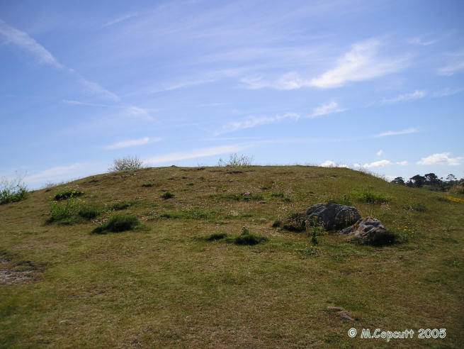
Ilot Roc'h-Avel submitted by thecaptain on 18th Jun 2006. Ilot Roc'h-Avel is a small island just offshore from Presqu'ile Ste-Marguerite, which can be easily walked to from the beach at Kerennoc when not high tide.
Just inland and up a bit from the cairn cut in half by the sea is another cairn, again of which certain edge set stones suggest remains of a chamber.
(View photo, vote or add a comment)
Log Text: Just offshore from Presqu'ile Ste-Marguerite near the town of Landéda are a few small islands which can be reached at low tide, upon which there are stone monuments. Ilot Roc'h-Avel is one of these, which can be easily walked to from the beach at Kerennoc when not high tide tide.
Towards the western tip of the islet is the fascinating remains of a cairn which is now half on the island with the other half now taken by the sea. At the seaward edge can be seen a drystone walled chamber - only the northern half of which remains. A few large stones lie dotted about on the shoreline, which with a bit of imagination can be placed into position for some sort of chamber.
Just inland and up a bit from the cairn cut in half by the sea is another cairn, again of which certain edge set stones suggest remains of a chamber.
There are lots of children out on the beach below, obviously a school visit. All sorts of fun and games are going on, girls shreiking when their feet touch weed or shells! Brilliant. AAaaaaaaarggghhhh - its a crab !!!!!!
Île Tariec menhir
Trip No.203 Entry No.517 Date Added: 28th May 2020
Site Type: Standing Stone (Menhir)
Country: France (Bretagne:Finistère (29))
Visited: Yes on 21st Jun 2005. My rating: Condition 2 Ambience 5 Access 2
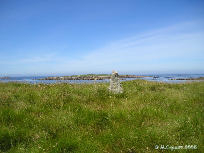
Île Tariec menhir submitted by thecaptain on 20th Jun 2006. On the seaward part of the island are the remains of a chambered cairn and a small menhir. The menhir is only about a metre high, a rock tapered towards the top, but in its position near the top of the island it can be clearly seen from all around.
This is the view to the west, with the reknowned island of Ile Guénioc and its cairns seen in the background.
(View photo, vote or add a comment)
Log Text: Just offshore from Presqu'ile Ste-Marguerite near the town of Landéda are a few small islands which can be reached at low tide, upon which there are stone monuments.
Ile Tariec is one of these, which can only be walked to for a short while each side of low tide, and the island became split into two parts in about 1876. The part of the island nearest to the mainland has the remains of a twelfth century hermitage on it, and the island was used to house dead and ill people in the past when suffering from plague, cholera etc.
On the outward part of the island are the remains of a dolmen and a small menhir. The menhir is only about a metre high, a rock tapered towards the top, but in its position near the top of the island it can be clearly seen from all around.
I was told by the camp site man that the midsummer solstice sun rise, when seen from here with your chin resting on the top of the menhir, supposedly rises between the legs of a dolmen on the main headland, but which has now unfortunately fallen in the dunes. Its a pity I wasn't here 4 or 5 hours ago, as I could have checked the theory. However, from a quick bit of reckoning and I don't think so, the mainland doesn't seem to stretch far enough to the north, but who am I to question the story? The northernmost tip of the mainland is at a bearing of about 075° from here.
